The Indians

Last updated

The Indians
The Indians, BVI.JPG
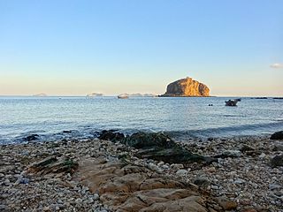
The Indians, with Tortola in the background
British Virgin Islands location map.svg
Red pog.svg
The Indians
The location of The Indians within the British Virgin Islands
Relief Map of Caribbean.png
Red pog.svg
The Indians
The Indians (Caribbean)
Geography
Location Caribbean Sea
Coordinates 18°19′54″N64°37′44″W / 18.3318°N 64.6288°W / 18.3318; -64.6288 Coordinates: 18°19′54″N64°37′44″W / 18.3318°N 64.6288°W / 18.3318; -64.6288
Archipelago Virgin Islands
Administration
United Kingdom
British Overseas Territory British Virgin Islands
Additional information
Time zone
ISO code VG

The Indians are an uninhabited small archipelago of islets in the British Virgin Islands in the Caribbean. They are west of the small British Pelican Island and east of the small US Flanagan Island.

Archipelago A group of islands

An archipelago, sometimes called an island group or island chain, is a chain, cluster or collection of islands, or sometimes a sea containing a small number of scattered islands.

Islet A very small island

An islet is a very small island.

British Virgin Islands British overseas territory in the Caribbean

The British Virgin Islands (BVI), officially simply the Virgin Islands, are a British Overseas Territory in the Caribbean, to the east of Puerto Rico. The islands are geographically part of the Virgin Islands archipelago and are located in the Leeward Islands of the Lesser Antilles.

They are located south of larger British Tortola Island and east of the large US Saint John Island.

Tortola island

Tortola is the largest and most populated of the British Virgin Islands, a group of islands that form part of the archipelago of the Virgin Islands. It has a surface area of 55.7 square kilometres with a total population of 23,908, with 9,400 residents in Road Town. Mount Sage is its highest point at 530 metres above sea level.

Saint John, U.S. Virgin Islands one of the main islands of the United States Virgin Islands

Saint John is one of the Virgin Islands in the Caribbean Sea and a constituent district of the United States Virgin Islands (USVI), an unincorporated territory of the United States.

They were so named because from a distance they were thought to resemble a Native American's head dress.

Bustle (regalia) traditional part of a Native American mans regalia worn during a dance exhibition

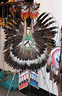
The Native American bustle is a traditional part of a man's regalia worn during a dance exhibition or wachipi and originates from the Plains region of the United States. In its modern form, the men's bustle is typically made of a string of eagle or hawk feathers attached to a backboard. Eagle and hawk feathers are sacred religious objects to Native American people and the possession of eagle and hawk feathers are protected by the eagle feather law.

The waters around the Indians contain much marine life, [1] and are also the second most popular dive site in the British Virgin Islands after the wreck of the RMS Rhone . The shallower areas of the Indians are also a popular snorkelling site and the area has several mooring balls for day use.

Scuba diving Using bottled air to swim underwater

Scuba diving is a mode of underwater diving where the diver uses a self-contained underwater breathing apparatus (scuba), which is completely independent of surface supply, to breathe underwater. Scuba divers carry their own source of breathing gas, usually compressed air, allowing them greater independence and freedom of movement than surface-supplied divers, and longer underwater endurance than breath-hold divers. Although the use of compressed air is common, a new mixture called enriched air (Nitrox) has been gaining popularity due to its benefit of reduced nitrogen intake during repetitive dives. Open circuit scuba systems discharge the breathing gas into the environment as it is exhaled, and consist of one or more diving cylinders containing breathing gas at high pressure which is supplied to the diver through a regulator. They may include additional cylinders for range extension, decompression gas or emergency breathing gas. Closed-circuit or semi-closed circuit rebreather scuba systems allow recycling of exhaled gases. The volume of gas used is reduced compared to that of open circuit, so a smaller cylinder or cylinders may be used for an equivalent dive duration. Rebreathers extend the time spent underwater compared to open circuit for the same gas consumption; they produce fewer bubbles and less noise than open circuit scuba which makes them attractive to covert military divers to avoid detection, scientific divers to avoid disturbing marine animals, and media divers to avoid bubble interference.

RMS <i>Rhone</i> Royal Mail Ship wrecked off Salt Island in the British Virgin Islands in a hurricane

RMS Rhone was a UK Royal Mail Ship owned by the Royal Mail Steam Packet Company (RMSP). She was wrecked off the coast of Salt Island in the British Virgin Islands on 29 October 1867 in a hurricane, killing 123 people. She is now a popular Caribbean wreck dive site.

Related Research Articles

Diego Garcia British atoll in the Indian Ocean

Diego Garcia is an atoll just south of the equator in the central Indian Ocean, and the largest of 60 small islands comprising the Chagos Archipelago. It was first discovered by Europeans and named by the Portuguese, settled by the French in the 1790s and transferred to British rule after the Napoleonic Wars. It was one of the "Dependencies" of the British Colony of Mauritius until it was detached for inclusion in the newly created British Indian Ocean Territory (BIOT) in 1965.

Eastern Caribbean dollar currency of eight of the nine members of the Organisation of Eastern Caribbean States

The Eastern Caribbean dollar is the currency of all seven full members and one associate member of the Organisation of Eastern Caribbean States (OECS). The successor to the British West Indies dollar, it has existed since 1965, and it is normally abbreviated with the dollar sign $ or, alternatively, EC$ to distinguish it from other dollar-denominated currencies. The EC$ is subdivided into 100 cents. It has been pegged to the United States dollar since 7 July 1976, and the exchange rate is US$1 = EC$2.70.

United States Virgin Islands group of islands in the Caribbean

The United States Virgin Islands, officially the Virgin Islands of the United States, is a group of islands in the Caribbean and an unincorporated and organized territory of the United States. The islands are geographically part of the Virgin Islands archipelago and are located in the Leeward Islands of the Lesser Antilles.

Vieques, Puerto Rico Island-municipality of Puerto Rico (U.S.)

Vieques, in full Isla de Vieques, is an island–municipality of Puerto Rico, United States in the northeastern Caribbean, part of an island grouping sometimes known as the Spanish Virgin Islands. Vieques is part of the Commonwealth of Puerto Rico, and retains strong influences from 400 years of Spanish presence in the island.

British Overseas Territories territories under the jurisdiction and sovereignty of the United Kingdom but not part of it

The British Overseas Territories (BOTs) or United Kingdom Overseas Territories (UKOTs) are 14 territories under the jurisdiction and sovereignty of the United Kingdom. They are remnants of the British Empire that have not been granted independence or have voted to remain British territories. These territories do not form part of the United Kingdom and, with the exception of Gibraltar, are not part of the European Union. Most of the permanently inhabited territories are internally self-governing, with the UK retaining responsibility for defence and foreign relations. Three are inhabited only by a transitory population of military or scientific personnel. They all share the British monarch as head of state.

West Indies Federation former federation of british colonies

The West Indies Federation, also known as the West Indies, the Federation of the West Indies or the West Indian Federation, was a short-lived political union that existed from 3 January 1958 to 31 May 1962. Various islands in the Caribbean that were colonies of the United Kingdom, including Trinidad and Tobago, Barbados, Jamaica, and those on the Leeward and Windward Islands, came together to form the Federation, with its capital in Port of Spain, Trinidad and Tobago. The expressed intention of the Federation was to create a political unit that would become independent from Britain as a single state—possibly similar to the Canadian Confederation, Australian Commonwealth, or Central African Federation; however, before that could happen, the Federation collapsed due to internal political conflicts over how the Federation itself would be governed or how it would viably function. The territories that would have become part of the Federation eventually became the nine contemporary sovereign states of Antigua and Barbuda, Barbados, Dominica, Grenada, Jamaica, Saint Kitts and Nevis, Saint Lucia, Saint Vincent and the Grenadines, and Trinidad and Tobago; with Anguilla, Montserrat, the Cayman Islands, and Turks and Caicos Islands becoming British overseas territories. British Guiana (Guyana) and British Honduras (Belize) held observer status within the West Indies Federation.

Saint Croix one of the main islands of the United States Virgin Islands

Saint Croix is an island in the Caribbean Sea, and a county and constituent district of the United States Virgin Islands (USVI), an unincorporated territory of the United States.

Saint Thomas, U.S. Virgin Islands One of the main islands of the United States Virgin Islands

Saint Thomas is one of the Virgin Islands in the Caribbean Sea and, together with Saint John, Water Island, Hassel Island and Saint Croix, a former Danish colony, form a county and constituent district of the United States Virgin Islands (USVI), an unincorporated territory of the United States. Located on the island is the territorial capital and port of Charlotte Amalie. As of the 2010 census, the population of Saint Thomas was 51,634 about 48.5% of the US Virgin Islands total. The district has a land area of 32 square miles (83 km2).

Anegada island

Anegada is the northernmost of the British Virgin Islands (BVI), a group of islands that form part of the archipelago of the Virgin Islands. It lies approximately 15 miles (24 km) north of Virgin Gorda. Anegada is the only inhabited British Virgin Island formed from coral and limestone, rather than being of volcanic origin. While the other islands are mountainous, Anegada is flat and low. Its highest point is only about 28 feet (8.5 m) above sea level, earning it its name, which is the Spanish term for the flooded land, "tierra anegada".

Road Town Town in British Virgin Islands, United Kingdom

Road Town, located on Tortola, is the capital of the British Virgin Islands. It is situated on the horseshoe-shaped Road Harbour in the centre of the island's south coast. The population was about 9,400 in 2004.

Necker Island (British Virgin Islands) island in the British Virgin Islands

Necker Island is a 30-hectare (74-acre) island in the British Virgin Islands just north of Virgin Gorda. The island's land is entirely owned by Sir Richard Branson, chairman of the Virgin Group, and is part of the Virgin Limited Edition portfolio of luxury properties. The whole island operates as a resort and can accommodate up to 34 guests, with additional room for six children.

The Islets of Mauritius includes nearly a hundred tiny islets and rocks scattered around the coast of Mauritius as well as Rodrigues.

Dog Islands island group

Dog Islands are a small group of islets among the British Virgin Islands in the Caribbean.

Pelican Island (British Virgin Islands) island in the British Virgin Islands

Pelican Island is an uninhabited island in the southwestern corner of the British Virgin Islands in the Caribbean. It is located immediately north of Norman Island, southwest of Peter Island. It is east of Flanagan Island in the southeastern corner of the US Virgin Islands.

Virgin Islander culture reflects the various peoples that have inhabited the present-day British Virgin Islands and U.S. Virgin Islands throughout history. Although the territories are politically separate, they maintain close cultural ties.

British Indian Ocean Territory Overseas territory of the United Kingdom

The British Indian Ocean Territory (BIOT) is an overseas territory of the United Kingdom situated in the Indian Ocean halfway between Tanzania and Indonesia, and directly south of the Maldives. The territory comprises the seven atolls of the Chagos Archipelago with over 1,000 individual islands – many very small – amounting to a total land area of 60 square kilometres (23 sq mi). The largest and most southerly island is Diego Garcia, 27 km2 (10 sq mi), the site of a joint military facility of the United Kingdom and the United States.

The Indian community in the United States Virgin Islands is made up of Indo-Caribbeans, Indian Americans and other persons of Indian origin. The first Indians in the United States Virgin Islands (USVI) arrived in the Danish colony of Saint Croix in June 1863 as indentured workers. However, all of the nearly 325 Indians who came to Saint Croix left the island by the 1870s. Nearly two-thirds returned to India, while the others emigrated to Trinidad. Some settled in that country, while others returned to India from Trinidad.

References

  1. "British Virgin Islands - Landmarks and Points of Interest". Smithsonian.com. 6 November 2007. Retrieved 8 January 2019.