History
The site was originally an earthen fort that was probably built by the Dutch privateer Joost van Dyk in 1620, when the truce, which had existed between the Dutch and the Spanish in Puerto Rico, ended.
Somewhere between 1623 and 1630, Fort Recovery may have been used as a barracks for wounded and ill soldiers; this is probably the source of the name "Fort Recovery". [1]
The Fort was later abandoned when the Territory fell into decline after the British seized control of the islands in 1672. However, during the turbulent colonial era commencing with the American Revolutionary War and extending to the Napoleonic wars the fort was rebuilt in its current form. When the British rebuilt the fort, the Martello Tower was clearly added to try to compensate for the lack of elevation of the cannon at the Fort.
The fort fell into disrepair again in the early 19th century when the main theater of conflict moved from the colonies to mainland Europe, and the economies of the islands were insufficient for its upkeep. It may also have been that, if the fort was designed to protect a source of freshwater, when the source dried up (there is no freshwater pond there today) the necessity for the fort disappeared.
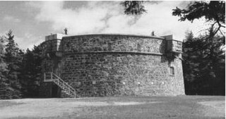
Design and location
The fort itself is of a tower structure. The fort is a very early example of a Martello Tower, a type of fortification used extensively along the British south-east coastline during the Napoleonic wars.
The location of the fort is somewhat unusual in that it is built close to the sea, on level ground (instead on in an elevated position on the hills rising behind it) and not close to either a port or population source. It has been suggested that the fort was built to protect a freshwater pond that was located near the area. [2] This is plausible; Tortola has no rivers, so wells and freshwater ponds were precious resources. The other possibility is that the fort was built to secure the trail that linked Soper's Hole to Pockwood Pond and Road Town as previous Spanish attacks had landed in Soper's Hole and then proceeded overland to Pockwood Pond and Road Town. It would have been difficult to fortify effectively Soper's Hole against Spanish cannon, but a fort on the soldiers' overland route could delay an attack and prevent another massacre of the type that occurred in 1646. The difficulty with this theory is that it still cannot explain why the fort was not elevated. Also, although it is not clear whether the fort was erected before or after the attacks of 1646 and 1647, it seems more likely that it was actually built before.

The British Virgin Islands, officially simply the Virgin Islands, are a British Overseas Territory in the Caribbean, to the east of Puerto Rico and the US Virgin Islands and north-west of Anguilla. The islands are geographically part of the Virgin Islands archipelago and are located in the Leeward Islands of the Lesser Antilles and part of the West Indies.

The History of the British Virgin Islands is usually, for convenience, broken up into five separate periods:
Martello towers, sometimes known simply as Martellos, are small defensive forts that were built across the British Empire during the 19th century, from the time of the French Revolutionary Wars onwards. Most were coastal forts.

Road Town, located on Tortola, is the capital of the British Virgin Islands. It is situated on the horseshoe-shaped Road Harbour in the centre of the island's south coast. The population was about 9,400 in 2004.
Tortola is the largest and most populated of the British Virgin Islands, a group of islands that form part of the archipelago of the Virgin Islands. It has a surface area of 55.7 square kilometres with a total population of 23,908, with 9,400 residents in Road Town. Mount Sage is its highest point at 530 metres above sea level.

Jost Van Dyke is the smallest of the four main islands of the British Virgin Islands, measuring roughly 8 square kilometres. It rests in the northern portion of the archipelago of the Virgin Islands, located in the Atlantic Ocean and Caribbean Sea. Jost Van Dyke lies about 8 km (5 mi) to the northwest of Tortola and 8 km (5 mi) to the north of Saint John. Little Jost Van Dyke lies off its eastern end.

Peter Island is a 720 hectare private island located in the British Virgin Islands (BVI). It is about 5 miles south-west from Road Town, Tortola. The island was named after Pieter Adriensen who was the brother of Abraham Adriensen, Patron of Tortola under the Dutch West India Company in the early 17th century. Pieter Adriensen and Joost van Dyk built a fort and slave pens at Great Harbour on Peter Island to facilitate privateering and the nascent trade in slaves from Angola.

Terrance B. Lettsome International Airport, previously known as Beef Island Airport, is the main airport serving the British Virgin Islands, a British overseas territory in the Caribbean. The airport serves as the gateway to just about all of the islands within the BVI. The airport is also a gateway for inter-Caribbean travelers headed to the nearby U.S. Virgin Islands. Many travellers fly into Beef Island, with the intention of taking a ferry to the other smaller British Virgin Islands. The airport is located on Beef Island, a small island off the main island of Tortola, to which it is connected by the Queen Elizabeth II Bridge.
Fort Purcell is a ruined fort near Pockwood Pond on the island of Tortola in the British Virgin Islands.
Joost van Dyk was a Dutch privateer who was one of the earliest European settlers in the British Virgin Islands in the seventeenth century, and established the first permanent settlements within the Territory. The islands of Jost Van Dyke and its smaller neighbor Little Jost Van Dyke, as well as Little Dix Bay on Virgin Gorda island, are named after him.
Fort Charlotte is a fort built on Harrigan's Hill, Tortola, British Virgin Islands. The fort was named after Charlotte of Mecklenburg-Strelitz, who was the wife of King George III.

Fort Burt is a colonial fort that was erected on the southwest edge of Road Town, Tortola in the British Virgin Islands above Road Reef Marina. The site is now a hotel and restaurant of the same name, and relatively little of the original structure remains. However, one of the original cannons has survived and stands on the veranda of the hotel, vigilantly looking over the harbour.

Fort George is a colonial fort which was erected on the northeast edge of Road Town, Tortola in the British Virgin Islands above Baugher's Bay. The site is now a ruin.

Road Town Fort is a colonial fort which was erected on Russell Hill in Road Town, Tortola in the British Virgin Islands above the town's main wharf. In historical records it is sometimes referred to as Fort Road Town. The fort subsequently fell into ruin, and in the 1960s the Bougainvillea clinic was built on top of the old structure. The strong room of the original fort, which was once the Territory's treasury, still survives today, and is now used as a storeroom by the clinic.

Scrub Island of the British Virgin Islands in the Caribbean is a part of the Lesser Antilles, a group of islands that are young volcanic or coral islands. It is home to the Scrub Island Resort Marina and Spa.

Willem Hunthum was a Dutch merchant and the last legally recognised Dutch owner of Tortola in what later became the British Virgin Islands. Hunthum was regarded as either Patron or "Governor" of the Territory from 1663 to 1672 when control of the islands passed to the British in the Third Anglo-Dutch War. Hunthum died at some point between 1672 and 1678.

The Whelk Point Fort was a colonial fort erected on the southeast part of Tortola in the British Virgin Islands. The fort fell into disrepair and ruin, and relatively little of the original structure remains. In 1992 a house was built over the original foundations of the fort, but the remains of the barracks can still be seen on the land behind the house. The ruins are on private property and are not generally accessible to the public.

The Dutch Virgin Islands is the collective name for the enclaves that the Dutch West India Company had in the Virgin Islands. The area was ruled by a director, whose seat was not permanent. The main reason for starting a colony here was that it lay strategically between the Dutch colonies in the south and New Netherland. The Dutch West India Company was mainly affected by the competition from Denmark, England and Spain. In 1680 the remaining islands became a British colony.
Events from the year 2018 in the British Virgin Islands.

The effects of Hurricane Irma in the British Virgin Islands were significant in terms of both human and socio-economic impact on the Territory. Hurricane Irma struck the British Virgin Islands as a Category 5 hurricane during the daylight hours of Wednesday, 6 September 2017. It caused widespread destruction, and killed a total of four people. The eye of the hurricane traveled over the three major islands in the group: Virgin Gorda, Tortola and Jost Van Dyke.
