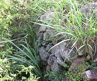
Fort Burt today. None of what is visible is part of the original fort, although one of the original cannon is visible poking out from the balcony.
Fort Burt is a colonial fort that was erected on the southwest edge of Road Town, Tortola in the British Virgin Islands above Road Reef Marina. The site is now a hotel and restaurant of the same name, and relatively little of the original structure remains. However, one of the original cannons has survived and stands on the veranda of the hotel, vigilantly looking over the harbour.
The original structure is believed by some[who?] to have been built at an unascertained date by the original Dutch settlers of the islands, although this is not certain as Spanish documents from this time refer to other forts on Tortola (which they attacked) and they make no mention of a defensive fortification at Fort Burt although the route of their attack (from Soper's hole, through Fort Purcell and on to Fort George would have taken them directly by the site of Fort Burt. In his book, Vernon Pickering suggests that the British erected the Fort on a site that they "erroneously believed" to have been the site of an earlier Dutch fort.[1] However, the main fortification was built (or rebuilt) by the British in 1776 at the outbreak of the American war of independence.
The fort was named after William Mathew Burt, Governor of the Leeward Islands from 1776 to 1781 (but not to be confused with Colonel William Burt, his great grandfather, who took the Territory for the British from the Dutch with a token force at the outbreak of the Third Anglo-Dutch War in 1672). Descendants of this family now live in Western Australia.
Fort Burt formed part of a formidable defensive network of forts around Road Town at this time, including Fort Road Town (under what is now the site of the Boungainvillea clinic), Fort George on Fort Hill on the north east side of the harbour, and Fort Charlotte set high above on Harrigan's Hill.
Fort Burt never actually fired a shot in anger under British command. The combination of the formidable martial defences of Road Town, and relatively small strategic and economic importance of Tortola persuaded both foreign colonial powers and privateers and pirates alike to focus on other targets within the region.
The fort later fell again into disrepair, and it was acquired in 1953 by Commander Christopher Hammersley and his socialite wife, who built what was then the only hotel on Tortola. The hotel has changed hands several times since, and is now in the ownership of the Pusser's chain.
The History of the British Virgin Islands is usually, for convenience, broken up into five separate periods:
Jamestown is a town in Newport County, Rhode Island in the United States. The population was 5,559 at the 2020 census. Jamestown is situated almost entirely on Conanicut Island, the second largest island in Narragansett Bay. It also includes the uninhabited Dutch Island and Gould Island.
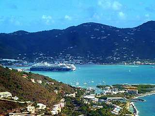
Road Town, located on Tortola, is the capital of the British Virgin Islands. It is situated on the horseshoe-shaped Road Harbour in the centre of the island's south coast. The population was about 15,000 in 2018.
Road Harbour, located in Road Town, Tortola, is the commercial seaport of the British Virgin Islands. There are a number of smaller marinas around the harbour, such as the Road Reef Marina and the Fort Burt Marina, an overnight small boat anchorage, customs and immigration offices. Inter island ferries stop at the ferry dock on the NW edge of Road Harbour next to Customs. Road Harbour is deep and large enough to handle many of the cruise ships that make Tortola a port of call.
St. Phillip's Anglican Church, also known as the African Church, in the Kingstown area of Tortola in British Virgin Islands, was built in 1840 by a community of Africans who had been liberated from illegal slave ships.
Fort Purcell is a ruined fort near Pockwood Pond on the island of Tortola in the British Virgin Islands.
Joost van Dyk was a Dutch privateer who was one of the earliest European settlers in the British Virgin Islands in the seventeenth century, and established the first permanent settlements within the Territory. The islands of Jost Van Dyke and its smaller neighbor Little Jost Van Dyke, as well as Little Dix Bay on Virgin Gorda island, are named after him.
Fort Charlotte is a fort built on Harrigan's Hill, Tortola, British Virgin Islands. The fort was named after Charlotte of Mecklenburg-Strelitz, who was the wife of King George III.
Fort George is a colonial fort which was erected on the northeast edge of Road Town, Tortola in the British Virgin Islands above Baugher's Bay. The site is now a ruin.
In common with most Caribbean countries, slavery in the British Virgin Islands forms a major part of the history of the Territory. One commentator has gone so far as to say: "One of the most important aspects of the History of the British Virgin Islands is slavery."
Fort Recovery is a fort on the West End of Tortola in the British Virgin Islands. In historical records, the fort is often referred to as Tower Fort, and the area around the fort is still referred to as "Towers" today. A hotel is now built around the Tower.
Road Town Fort is a colonial fort which was erected on Russell Hill in Road Town, Tortola in the British Virgin Islands above the town's main wharf. In historical records it is sometimes referred to as Fort Road Town. The fort subsequently fell into ruin, and in the 1960s the Bougainvillea clinic was built on top of the old structure. The strong room of the original fort, which was once the Territory's treasury, still survives today, and is now used as a storeroom by the clinic.
Wickams Cay and Little Wickam's Cay were former islands of the British Virgin Islands in the Caribbean. They were both located in Road Harbour, but due to reclamation of land projects in Tortola, Wickhams Cay now makes up part of Road Town, the capital of the British Virgin Islands. The areas are known as Wickhams Cay and Wickhams Cay II. Also included in the same reclamation projects were former islands known as Bird Cay and Dead Horse Cay.
The Cooten Bay ruin is a ruin in Cooten Bay, on the north side of Tortola in the British Virgin Islands. The ruin probably dates from the sugar plantation era, although the fortification of the property with cannon may suggest an earlier date. It was presumed abandoned during the economic collapse of the British Virgin Islands during the mid-19th century, when many plantations were abandoned.
The Whelk Point Fort was a colonial fort erected on the southeast part of Tortola in the British Virgin Islands. The fort fell into disrepair and ruin, and relatively little of the original structure remains. In 1992 a house was built over the original foundations of the fort, but the remains of the barracks can still be seen on the land behind the house. The ruins are on private property and are not generally accessible to the public.
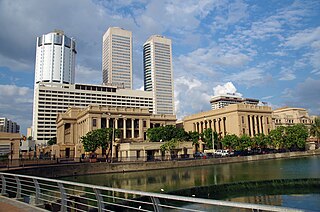
Fort (Colombo) is the central business district of Colombo in Sri Lanka. It is the financial district of Colombo and the location of the Colombo Stock Exchange (CSE) and the World Trade Centre of Colombo from which the CSE operates. It is also the location of the Bank of Ceylon headquarters. Along the foreshore of the Fort area is the Galle Face Green Promenade, built in 1859 under the governance of Sir Henry George Ward, the Governor of Ceylon during British colonial era. Fort is also home to the General Post Office, hotels, government departments and offices.
The Dutch Virgin Islands is the collective name for the enclaves that the Dutch West India Company had in the Virgin Islands. The area was ruled by a director, whose seat was not permanent. The main reason for starting a colony here was that it lay strategically between the Dutch colonies in the south and New Netherland. The Dutch West India Company was mainly affected by the competition from Denmark, England and Spain. In 1680 the remaining islands became a British colony.
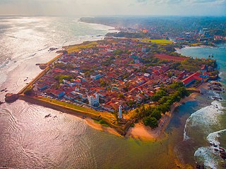
Galle Fort, in the Bay of Galle on the southwest coast of Sri Lanka, was built first in 1588 by the Portuguese, then extensively fortified by the Dutch during the 17th century from 1649 onwards. It is a historical, archaeological and architectural heritage monument, which even after more than 432 years maintains a polished appearance, due to extensive reconstruction work done by Archaeological Department of Sri Lanka.
Fort William was a fort in St. John's built in 1698 to protect English interests on Newfoundland, primarily against French opposition. It was the original headquarters of the British garrison in Newfoundland. A second fort, known as Fort George was situated at the east end of the harbour connected by a subterranean passage with Fort William. On the south side of the Narrows, there was a third fortification called the Castle. Garrison headquarters were later moved to Fort Townshend, which was built between 1775-1779.
This page is based on this Wikipedia article Text is available under the CC BY-SA 4.0 license; additional terms may apply. Images, videos and audio are available under their respective licenses.