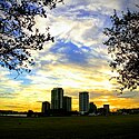
Jacksonville is a city located on the Atlantic coast of northeastern Florida, the most populous city proper in the state and the largest city by area in the contiguous United States as of 2020. It is the seat of Duval County, with which the city government consolidated in 1968. Consolidation greatly increased its population relative to its extended size which placed most of its metropolitan population within the city limits. As of July 2022, Jacksonville's population is 971,319, making it the most populous city in the Southeastern United States and the largest in the South outside the state of Texas. With a population of 1,733,937, the Jacksonville metropolitan area ranks as Florida's fourth-largest metropolitan region.
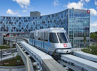
The Jacksonville Skyway is an automated people mover in Jacksonville, Florida. It opened in 1989 and is operated by the Jacksonville Transportation Authority (JTA). The skyway has three stations in Downtown Jacksonville and was extended in 1996 following a conversion from its original technology to Bombardier Transportation equipment. It was expanded again in 1998 and 2000. The currently fare-free system comprises two routes across 2.5 miles (4.0 km) of track, serving eight stations, and crosses the St. Johns River on the Acosta Bridge. In 2022, the system had a ridership of 276,600, or about 1,000 per day as of the first quarter of 2023.

The St. Elmo W. Acosta Bridge spans the St. Johns River in Jacksonville, Florida on a fixed span. It is named for City Councilman St. Elmo W. Acosta, who convinced voters to approve a $950,000 bond issue for the original bridge at the site. It carries a total of six lanes of SR 13 with the two-track Jacksonville Skyway in the median and sidewalks on the outside.
Riverplace or River Place may refer to:
Central station is a Jacksonville Skyway monorail station in Jacksonville, Florida. It is the transfer point for the system's Northbank and Southbank lines. It is located on Bay Street between Pearl and Julia Streets in Downtown Jacksonville.

San Marco station is a Jacksonville Skyway people mover station in Jacksonville, Florida. It is located at the corner of San Marco Boulevard and Mary Street in the Southbank area of Downtown Jacksonville. Nearby points of interest include the Museum of Science and History and Friendship Fountain Park.

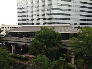
Riverplace station is a station of the Jacksonville Skyway in Jacksonville, Florida. It is located at the corner of Mary Street and Flagler Avenue in the Southbank area of Downtown Jacksonville. It is near Riverplace Tower.

Kings Avenue station is a Jacksonville Skyway station in Jacksonville, Florida. It is located on Onyx Street between Prudential Drive and Louisa Street in the Southbank area of Downtown Jacksonville.
Downtown Jacksonville is the historic core and central business district (CBD) of Jacksonville, Florida. It comprises the earliest area of the city to be developed and is located in its geographic center along the narrowing point of the St. Johns River.

There are more than 500 neighborhoods within the area of Jacksonville, Florida, the largest city in the contiguous United States by area. These include Downtown Jacksonville and surrounding neighborhoods. Additionally, greater Jacksonville is traditionally divided into several major sections with amorphous boundaries: Northside, Westside, Southside, and Arlington, as well as the Jacksonville Beaches.

The Jacksonville Landing was a festival marketplace in Downtown Jacksonville, Florida, at the intersection of Independent Drive and Laura Street, along the Jacksonville Riverwalk. It was built by the Rouse Company for $37.5 million, opened in 1987, and officially closed after the 4th of July festivities in 2019. Demolition began about October 8, 2019. The 126,000 square feet (11,706 m2) center was comparable to New York City's South Street Seaport, Boston's Faneuil Hall, and Miami's Bayside Marketplace, all developed by Rouse.

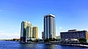
The Riverplace Tower is a 28-floor office building on the south bank of the St. Johns River in Jacksonville, Florida. At the time of its construction, it was the tallest building in the state of Florida and was the defining landmark in Jacksonville's skyline. On April 18, 2012, the American Institute of Architects's Florida Chapter placed the building on its list of Florida Architecture: 100 Years. 100 Places as the Riverplace Tower / Formerly Gulf Life Tower.

The Jacksonville Riverwalks are a network of multi-use trails and open space developments along both the north and south banks of the St. Johns River in Jacksonville, Florida. The roughly 2-mile (3.2 km) Downtown Northbank portion travels alongside the Hyatt Regency Jacksonville, Jacksonville Landing, Times-Union Center for the Performing Arts, CSX Transportation Building, and extends into the Brooklyn district. The 1.25-mile (2.01 km) Southbank portion of the trail connects local landmarks such as Friendship Fountain, Museum of Science and History and Riverplace Tower.

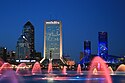
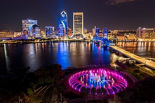
Friendship Fountain is a large fountain in Jacksonville, Florida. It is in St. Johns River Park at the west end of Downtown Jacksonville's Southbank Riverwalk attraction. The world's largest and tallest fountain when it opened, it has been one of Jacksonville's most recognizable and popular attractions.

Eight Forty One is a 309 feet, 22-floor office building on the south bank of St. Johns River in Jacksonville, Florida. Completed in 1955, it was the tallest building in the city for 13 years until surpassed by the Riverplace Tower. It was "The Tallest Office Building in the South" and the tallest in Florida until NASA's Vehicle Assembly Building was completed in 1965. The building's former names include the Aetna Building, Prudential Plaza I or One Prudential Plaza, and the Prudential Building.

The Jacksonville transportation network includes ground, air, and sea options for passenger and freight transit. The Jacksonville Port Authority (Jaxport) operates the Port of Jacksonville, which includes container shipping facilities at Blount Island Marine Terminal, the Talleyrand Marine Terminal and the Dames Point Marine Terminal. Jacksonville Aviation Authority managers Jacksonville International Airport in Northside, as well as several smaller airports. The Jacksonville Transportation Authority (JTA) operates bus, people mover, and park-n-ride services throughout the city and region. A major bus terminal at the intermodal Rosa Parks Transit Station serves as JTA's main transit hub. Various intercity bus companies terminate near Central Station. Amtrak operates passenger rail service to and from major cities throughout North America. The city is bisected by major highways, I-95 and I-10, I-295 creates a full beltway around the city.
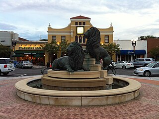
San Marco is a neighborhood of Jacksonville, Florida, south of Downtown across the St. Johns River. The neighborhood was formerly the independent city of South Jacksonville until it was annexed by Jacksonville in 1932. The neighborhood is primarily residential, with an integrated commercial sector known as San Marco Square.

The architecture of Jacksonville is a combination of historic and modern styles reflecting the city's early position as a regional center of business. According to the National Trust for Historic Preservation, there are more buildings built before 1967 in Jacksonville than any other city in Florida, though few structures in the city center predate the Great Fire of 1901. Numerous buildings in the city have held state height records, dating as far back as 1902, and last holding a record in 1981.

The First Coast Flyer is a bus rapid transit (BRT) system in Jacksonville, Florida, owned and operated by the Jacksonville Transportation Authority (JTA). It currently consists of four radial routes running north, southwest, southeast, and east from the Jacksonville Regional Transportation Center in Downtown Jacksonville, where it connects to the Jacksonville Skyway. The first phase, including stations in Downtown Jacksonville and the northbound Green Line, opened in December 2015, with the southbound Blue Line opening in 2016. Additional phases, including the eastbound Red Line and southwestern Orange Line opened in 2018 and 2021, respectively.

Laura Street is a north–south street in Jacksonville, Florida, United States, named for the daughter of the city's founder, Isaiah D. Hart. Historically, the downtown portion of Laura Street has been considered the financial district of Jacksonville.