Spring Lake, Isanti County, Minnesota

Last updated
Spring Lake
USA Minnesota location map.svg
Red pog.svg
Spring Lake
Usa edcp location map.svg
Red pog.svg
Spring Lake
Coordinates: 45°32′32″N93°03′57″W / 45.54222°N 93.06583°W / 45.54222; -93.06583 Coordinates: 45°32′32″N93°03′57″W / 45.54222°N 93.06583°W / 45.54222; -93.06583
Country United States
State Minnesota
County Isanti
Township North Branch Township
Elevation
948 ft (289 m)
Population
  Total70
Time zone UTC-6 (Central (CST))
  Summer (DST) UTC-5 (CDT)
Area code(s) 651
GNIS feature ID652476 [1]

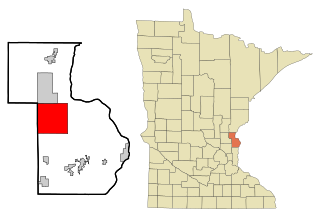
Spring Lake is an unincorporated community in North Branch Township, Isanti County, Minnesota, United States.

Unincorporated area Region of land not governed by own local government

In law, an unincorporated area is a region of land that is not governed by a local municipal corporation; similarly an unincorporated community is a settlement that is not governed by its own local municipal corporation, but rather is administered as part of larger administrative divisions, such as a township, parish, borough, county, city, canton, state, province or country. Occasionally, municipalities dissolve or disincorporate, which may happen if they become fiscally insolvent, and services become the responsibility of a higher administration. Widespread unincorporated communities and areas are a distinguishing feature of the United States and Canada. In most other countries of the world, there are either no unincorporated areas at all, or these are very rare; typically remote, outlying, sparsely populated or uninhabited areas.

North Branch Township, Isanti County, Minnesota Township in Minnesota, United States

North Branch Township is a township in Isanti County, Minnesota, United States. The population was 1,654 at the 2000 census.

Isanti County, Minnesota County in the United States

Isanti County is a county in the U.S. state of Minnesota. As of the 2010 United States Census, the population was 37,816. Its county seat is Cambridge.

The community is located 4.5 miles (7.2 km) northwest of the city of North Branch at the junction of State Highway 95 (MN 95) and Isanti County Road 21 (Cedar Crest Trail). Spring Lake Road NE also serves the community.

North Branch, Minnesota City in Minnesota, United States

North Branch is a city in Chisago County, Minnesota, United States, located at the junction of Interstate 35 and Minnesota State Highway 95. The population was 10,125 at the 2010 census. It is named for the north branch of the Sunrise River, which flows through the city.

Junction (traffic) location where traffic can change between different routes, directions, or sometimes modes, of travel

A junction, when discussed in the context of transport, is a location where traffic can change between different routes, directions, or sometimes modes, of travel.

Minnesota State Highway 95 is a highway in east-central Minnesota, which runs from its intersection with State Highway 23 near St. Cloud and continues east and south to its southern terminus at its intersection with U.S. Highways 61 / 10 (co-signed) at Cottage Grove.

Spring Lake is 8 miles east of Cambridge.

Related Research Articles

Bowstring, Minnesota Unincorporated community in Minnesota, United States

Bowstring is an unincorporated community in Bowstring Township, Itasca County, Minnesota, United States.

Bear River, Minnesota Unincorporated community in Minnesota, United States

Bear River is an unincorporated community in Itasca and Saint Louis counties in the U.S. state of Minnesota.

Talmoon, Minnesota Unincorporated community in Minnesota, United States

Talmoon is an unincorporated community in Itasca County, Minnesota, United States.

Crown, Minnesota Unincorporated community in Minnesota, United States

Crown is an unincorporated community in Stanford Township, Isanti County, Minnesota, United States. The community is located north of St. Francis.

Pine Brook, Minnesota Unincorporated community in Minnesota, United States

Pine Brook is an unincorporated community in Isanti County, Minnesota, United States.

Bradford, Minnesota Unincorporated community in Minnesota, United States

Bradford is an unincorporated community in Bradford Township, Isanti County, Minnesota, United States.

Dalbo, Minnesota Unincorporated community in Minnesota, United States

Dalbo is an unincorporated community in Dalbo Township, Isanti County, Minnesota, United States.

Blomford, Minnesota Unincorporated community in Minnesota, United States

Blomford is an unincorporated community in Isanti County, Minnesota, United States.

Grandy, Minnesota Unincorporated community in Minnesota, United States

Grandy is an unincorporated community in Cambridge Township, Isanti County, Minnesota, United States.

Stanchfield, Minnesota Unincorporated community in Minnesota, US

Stanchfield is an unincorporated community and census-designated place (CDP) in Stanchfield Township, Isanti County, Minnesota, United States. As of the 2010 census, its population was 118.

Oxlip, Minnesota Unincorporated community in Minnesota, United States

Oxlip is an unincorporated community in Isanti County, Minnesota, United States. The community is located within Spencer Brook Township and Bradford Township.

Stanley, Minnesota Unincorporated community in Minnesota, United States

Stanley is an unincorporated community in Isanti Township, Isanti County, Minnesota, United States.

Walbo, Minnesota Unincorporated community in Minnesota, United States

Walbo is an unincorporated community in Springvale Township, Isanti County, Minnesota, United States.

Weber, Minnesota Unincorporated community in Minnesota, United States

Weber is an unincorporated community in Isanti County, Minnesota, United States.

Edgewood, Minnesota Unincorporated community in Minnesota, United States

Edgewood is an unincorporated community in Isanti Township, Isanti County, Minnesota, United States.

Max, Minnesota Unincorporated community in Minnesota, United States

Max is an unincorporated community in Max Township, Itasca County, Minnesota, United States; located within the Chippewa National Forest and the Leech Lake Indian Reservation.

Wirt, Minnesota Unincorporated community in Minnesota, United States

Wirt is an unincorporated community in Wirt Township, Itasca County, Minnesota, United States; located within the Chippewa National Forest.

Jessie Lake, Minnesota Unincorporated community in Minnesota, United States

Jessie Lake is an unincorporated community in Lake Jessie Township, Itasca County, Minnesota, United States; located within the Chippewa National Forest. The community is located between Wirt and Talmoon; along Itasca County Road 4.

Greeley, Minnesota Unincorporated community in Minnesota, United States

Greeley is an unincorporated community in Royalton Township, Pine County, Minnesota, United States.

References

  1. "US Board on Geographic Names". United States Geological Survey. 2007-10-25. Retrieved 2008-01-31.