Springvale Township, Isanti County, Minnesota

Last updated
Springvale Township
USA Minnesota location map.svg
Red pog.svg
Springvale Township
Location within the state of Minnesota
Usa edcp location map.svg
Red pog.svg
Springvale Township
Springvale Township (the United States)
Coordinates: 45°35′34″N93°20′1″W / 45.59278°N 93.33361°W / 45.59278; -93.33361 Coordinates: 45°35′34″N93°20′1″W / 45.59278°N 93.33361°W / 45.59278; -93.33361
Country United States
State Minnesota
County Isanti
Area
  Total35.3 sq mi (91.5 km2)
  Land34.8 sq mi (90.3 km2)
  Water0.5 sq mi (1.2 km2)
Elevation
958 ft (292 m)
Population
 (2000)
  Total1,384
  Density39.7/sq mi (15.3/km2)
Time zone UTC-6 (Central (CST))
  Summer (DST) UTC-5 (CDT)
FIPS code 27-62086 [1]
GNIS feature ID0665680 [2]

Springvale Township is a township in Isanti County, Minnesota, United States. The population was 1,384 at the 2000 census.

Contents

Geography

According to the United States Census Bureau, the township has a total area of 35.3 square miles (91.5 km2), of which 34.8 square miles (90.3 km2) is land and 0.5 square mile (1.2 km2) (1.36%) is water.

Demographics

Historical population
CensusPop.
1870 93
1880 350276.3%
1890 57062.9%
1900 74731.1%
1910 7804.4%
1920 8316.5%
1930 721−13.2%
1940 690−4.3%
1950 610−11.6%
1960 580−4.9%
1970 81740.9%
1980 1,04628.0%
1990 1,1136.4%
2000 1,38424.3%
2010 1,4474.6%
U.S. Decennial Census [3]

As of the census [1] of 2000, there were 1,384 people, 475 households, and 388 families residing in the township. The population density was 39.7 inhabitants per square mile (15.3/km2). There were 488 housing units at an average density of 14.0/sq mi (5.4/km2). The racial makeup of the township was 97.83% White, 0.22% African American, 0.72% Asian, 0.22% from other races, and 1.01% from two or more races. Hispanic or Latino of any race were 1.01% of the population.

There were 475 households, out of which 37.9% had children under the age of 18 living with them, 71.4% were married couples living together, 5.9% had a female householder with no husband present, and 18.3% were non-families. 13.3% of all households were made up of individuals, and 3.8% had someone living alone who was 65 years of age or older. The average household size was 2.90 and the average family size was 3.19.

In the township the population was spread out, with 29.6% under the age of 18, 6.3% from 18 to 24, 30.4% from 25 to 44, 26.3% from 45 to 64, and 7.4% who were 65 years of age or older. The median age was 36 years. For every 100 females, there were 105.3 males. For every 100 females age 18 and over, there were 103.1 males.

The median income for a household in the township was $53,942, and the median income for a family was $57,632. Males had a median income of $39,940 versus $25,375 for females. The per capita income for the township was $20,260. About 2.1% of families and 3.7% of the population were below the poverty line, including 3.4% of those under age 18 and 7.5% of those age 65 or over.

Related Research Articles

<span class="mw-page-title-main">Lincoln Township, Arenac County, Michigan</span> Civil township in Michigan, United States

Lincoln Township is a civil township of Arenac County in the U.S. state of Michigan. The population was 942 at the 2010 census. The city of Standish borders the township on the northeast but is administered autonomously.

Convis Township is a civil township of Calhoun County in the U.S. state of Michigan. It is part of the Battle Creek, Michigan Metropolitan Statistical Area. The population was 1,636 at the 2010 census.

<span class="mw-page-title-main">Trout Lake Township, Michigan</span> Civil township in Michigan, United States

Trout Lake Township is a civil township of Chippewa County in the U.S. state of Michigan. The population was 332 at the 2020 census, down from 384 at the 2010 census.

<span class="mw-page-title-main">Bengal Township, Michigan</span> Civil township in Michigan, United States

Bengal Township is a civil township of Clinton County in the U.S. state of Michigan. The population was 1,188 at the 2010 census.

Alabaster Township is a civil township of Iosco County in the U.S. state of Michigan. the 2010 census has the township population of 487.

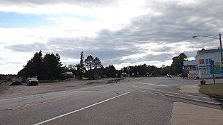
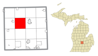
Montmorency Township is a civil township of Montmorency County in the U.S. state of Michigan. The population was 1,202 at the 2000 census.

Ferry Township is a civil township of Oceana County in the U.S. state of Michigan. The population was 1,296 at the 2000 census.

Leech Lake Township is a township in Cass County, Minnesota, United States. The population was 384 at the 2000 census. This township took its name from Leech Lake.

Mayville Township is a township in Houston County, Minnesota, United States. The population was 427 at the 2000 census.

Helga Township is a township in Hubbard County, Minnesota, United States. The population was 1,109 at the 2000 census.

North Branch Township is a township in Isanti County, Minnesota, United States. The population was 1,654 at the 2000 census.

Iron Range Township is a township in Itasca County, Minnesota, United States. The population was 649 at the 2010 census.

Hillman Township is a township in Kanabec County, Minnesota, United States. The population was 384 at the 2000 census.

Bellevue Township is a township in Morrison County, Minnesota, United States. The population was 1,115 at the 2000 census.

Wild Rice Township is a township in Norman County, Minnesota, United States. The population was 334 at the 2000 census.

Winchester Township is a township in Norman County, Minnesota, United States. The population was 74 at the 2000 census.

St. Joseph Township is a township in Stearns County, Minnesota, United States. The population was 1,924 at the 2010 census. The township borders the western side of the cities of St. Cloud and Waite Park, and completely surrounds the city of St. Joseph. All are components of the St. Cloud Metropolitan Statistical Area.

Chatham Township is a township in Wright County, Minnesota, United States. The population was 1,162 at the 2000 census.

<span class="mw-page-title-main">Lower Alsace Township, Berks County, Pennsylvania</span> Township in Pennsylvania, United States

Lower Alsace Township is a township in Berks County, Pennsylvania. The population was 4,475 at the 2010 census. By area, it is the smallest township in Berks County.

<span class="mw-page-title-main">Tunkhannock Township, Wyoming County, Pennsylvania</span> Township in Pennsylvania, United States

Tunkhannock Township is a township in Wyoming County, Pennsylvania, United States. The population was 3,976 at the 2020 census.

References

  1. 1 2 "U.S. Census website". United States Census Bureau . Retrieved 2008-01-31.
  2. "US Board on Geographic Names". United States Geological Survey. 2007-10-25. Retrieved 2008-01-31.
  3. "Census of Population and Housing". Census.gov. Retrieved May 27, 2019.