Stanchfield Township, Isanti County, Minnesota

Last updated
Stanchfield Township
USA Minnesota location map.svg
Red pog.svg
Stanchfield Township
Location within the state of Minnesota
Usa edcp location map.svg
Red pog.svg
Stanchfield Township
Stanchfield Township (the United States)
Coordinates: 45°41′9″N93°11′44″W / 45.68583°N 93.19556°W / 45.68583; -93.19556 Coordinates: 45°41′9″N93°11′44″W / 45.68583°N 93.19556°W / 45.68583; -93.19556
Country United States
State Minnesota
County Isanti
Area
  Total34.6 sq mi (89.7 km2)
  Land33.8 sq mi (87.6 km2)
  Water0.8 sq mi (2.1 km2)
Elevation
938 ft (286 m)
Population
 (2000)
  Total1,120
  Density33.1/sq mi (12.8/km2)
Time zone UTC-6 (Central (CST))
  Summer (DST) UTC-5 (CDT)
ZIP code
55080
Area code 320
FIPS code 27-62347 [1]
GNIS feature ID0665692 [2]

Stanchfield Township is a township in Isanti County, Minnesota, United States. The population was 1,120 at the 2000 census.

Contents

History

Stanchfield Creek was named for Daniel Stanchfield, an explorer of the area and afterward state politician. [3]

Geography

According to the United States Census Bureau, the township has a total area of 34.6 square miles (89.7 km2), of which 33.8 square miles (87.5 km2) is land and 0.8 square mile (2.1 km2) (2.34%) is water.

Stanchfield Township is along Lower Stanchfield Branch.

Demographics

Historical population
CensusPop.
1880 491
1890 75954.6%
1900 1,17554.8%
1910 1,005−14.5%
1920 1,11911.3%
1930 955−14.7%
1940 9893.6%
1950 861−12.9%
1960 811−5.8%
1970 95117.3%
1980 1,07713.2%
1990 1,060−1.6%
2000 1,1205.7%
2010 1,2097.9%
U.S. Decennial Census [4]

As of the census [1] of 2010, there were 1,209 people, 442 households, and 326 families residing in the township. The population density was 33.1 inhabitants per square mile (12.8/km2). There were 479 housing units at an average density of 12.6/sq mi (4.9/km2). The racial makeup of the township was 96.9% White, 0.2% African American, 0.4% Native American, 0.7% Asian, and 1.6% from two or more races. Hispanic or Latino of any race were 1.8% of the population.

There were 442 households, out of which 31.0% had children under the age of 18 living with them, 62.2% were married couples living together, 5.9% had a female householder with no husband present, and 26.2% were non-families. 20.4% of all households were made up of individuals, and 7.0% had someone living alone who was 65 years of age or older. The average household size was 2.69 and the average family size was 3.15.

In the township the population was spread out, with 27.4% under the age of 18, 5.2% from 18 to 24, 24.1% from 25 to 44, 29.5% from 45 to 64, and 13.8% who were 65 years of age or older. The median age was 39.1 years. For every 100 females, there were 108.4 males. For every 100 females age 18 and over, there were 113.6 males.

The median income for a household in the township was $66,719, and the median income for a family was $82,222. Males had a median income of $52,292 versus $39,844 for females. The per capita income for the township was $28,007. About 4.2% of families and 9.0% of the population were below the poverty line, including 9.2% of those under age 18 and 7.5% of those age 65 or over.

Related Research Articles

Glen Township is a township in Aitkin County, Minnesota, United States. The population was 450 as of the 2010 census.

Beauford Township is a township in Blue Earth County, Minnesota, United States. The population was 442 as of the 2000 census.

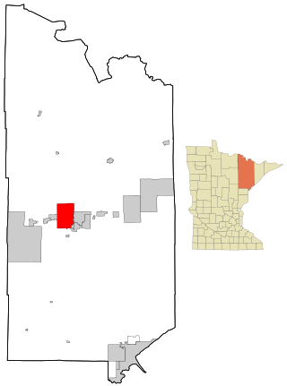
Sterling Township is a township in Blue Earth County, Minnesota, United States. The population was 276 as of the 2000 census.

Moorhead Township is a township in Clay County, Minnesota, United States. The population was 442 at the 2000 census.

Jenkins Township is a township in Crow Wing County, Minnesota, United States. The population was 425 at the 2000 census.

Oak Lawn Township is a township in Crow Wing County, Minnesota, United States. The population was 1,793 at the 2000 census.

Roosevelt Township is a township in Crow Wing County, Minnesota, United States. The population was 534 at the 2000 census. Roosevelt Township was named for Theodore Roosevelt, 26th President of the United States.

Moscow Township is a township in Freeborn County, Minnesota, United States. The population was 605 at the 2000 census.

Caledonia Township is a township in Houston County, Minnesota, United States. The population was 625 at the 2000 census.

Hubbard Township is a township in Hubbard County, Minnesota, United States. The population was 786 at the 2000 census.

<span class="mw-page-title-main">Racine, Minnesota</span> City in Minnesota, United States

Racine is a city in Racine Township, Mower County, Minnesota, United States. The population was 442 at the 2010 census.

Racine Township is a township in Mower County, Minnesota, United States. The population was 445 at the time of the 2000 census. The largest town in the township is Racine with a population of 442 as of the 2010 census.. All other area in the township is unincorporated.

Corliss Township is a township in Otter Tail County, Minnesota, United States. The population was 462 at the 2000 census.

Edna Township is a township in Otter Tail County, Minnesota, United States. The population was 921 at the 2000 census.

Elmo Township is a township in Otter Tail County, Minnesota, United States. The population was 344 at the 2000 census.

Leaf Mountain Township is a township in Otter Tail County, Minnesota, United States. The population was 309 at the 2000 census.

Otter Tail Township is a township in Otter Tail County, Minnesota, United States. The population was 556 at the 2000 census.

Rush Lake Township is a township in Otter Tail County, Minnesota, United States. The population was 966 at the 2000 census.

<span class="mw-page-title-main">Mountain Iron, Minnesota</span> City in Minnesota, United States

Mountain Iron is a city in Saint Louis County, Minnesota, United States, in the heart of the Mesabi Range. The population was 2,878 at the 2020 census.

Stanchfield is an unincorporated community and census-designated place (CDP) in Stanchfield Township, Isanti County, Minnesota, United States. As of the 2020 census, its population was 103.

References

  1. 1 2 "U.S. Census website". United States Census Bureau . Retrieved 2008-01-31.
  2. "US Board on Geographic Names". United States Geological Survey. 2007-10-25. Retrieved 2008-01-31.
  3. Upham, Warren (1920). Minnesota Geographic Names: Their Origin and Historic Significance. Minnesota Historical Society. p.  250.
  4. "Census of Population and Housing". Census.gov. Retrieved May 27, 2019.