
Apollo 14 was the eighth crewed mission in the United States Apollo program, the third to land on the Moon, and the first to land in the lunar highlands. It was the last of the "H missions", landings at specific sites of scientific interest on the Moon for two-day stays with two lunar extravehicular activities.

Apollo 16 was the tenth crewed mission in the United States Apollo space program, administered by NASA, and the fifth and penultimate to land on the Moon. It was the second of Apollo's "J missions", with an extended stay on the lunar surface, a focus on science, and the use of the Lunar Roving Vehicle (LRV). The landing and exploration were in the Descartes Highlands, a site chosen because some scientists expected it to be an area formed by volcanic action, though this proved not to be the case.

Apollo 17 was the eleventh and final mission of NASA's Apollo program, the sixth and most recent time humans have set foot on the Moon or traveled beyond low Earth orbit. Commander Gene Cernan and Lunar Module Pilot Harrison Schmitt walked on the Moon, while Command Module Pilot Ronald Evans orbited above. Schmitt was the only professional geologist to land on the Moon; he was selected in place of Joe Engle, as NASA had been under pressure to send a scientist to the Moon. The mission's heavy emphasis on science meant the inclusion of a number of new experiments, including a biological experiment containing five mice that was carried in the command module.

A seismometer is an instrument that responds to ground noises and shaking such as caused by quakes, volcanic eruptions, and explosions. They are usually combined with a timing device and a recording device to form a seismograph. The output of such a device—formerly recorded on paper or film, now recorded and processed digitally—is a seismogram. Such data is used to locate and characterize earthquakes, and to study the internal structure of Earth.
Polymer-bonded explosives, also called PBX or plastic-bonded explosives, are explosive materials in which explosive powder is bound together in a matrix using small quantities of a synthetic polymer. PBXs are normally used for explosive materials that are not easily melted into a casting, or are otherwise difficult to form.
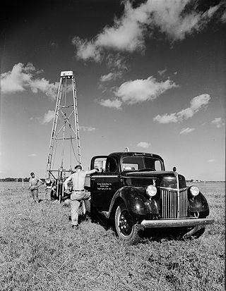
A geophone is a device that converts ground movement (velocity) into voltage, which may be recorded at a recording station. The deviation of this measured voltage from the base line is called the seismic response and is analyzed for structure of the Earth.

Hexanitrostilbene (HNS), also called JD-X, is an organic compound with the formula [(O2N)3C6H2CH]2. It is a yellow-orange solid. It is used as a heat-resistant high explosive. It is slightly soluble (0.1 - 5 g/100 mL) in butyrolactone, DMF, DMSO, and N-methylpyrrolidone.
Exploration geophysics is an applied branch of geophysics and economic geology, which uses physical methods at the surface of the Earth, such as seismic, gravitational, magnetic, electrical and electromagnetic, to measure the physical properties of the subsurface, along with the anomalies in those properties. It is most often used to detect or infer the presence and position of economically useful geological deposits, such as ore minerals; fossil fuels and other hydrocarbons; geothermal reservoirs; and groundwater reservoirs. It can also be used to detect the presence of unexploded ordnance.

A seismic source is a device that generates controlled seismic energy used to perform both reflection and refraction seismic surveys. A seismic source can be simple, such as dynamite, or it can use more sophisticated technology, such as a specialized air gun. Seismic sources can provide single pulses or continuous sweeps of energy, generating seismic waves, which travel through a medium such as water or layers of rocks. Some of the waves then reflect and refract and are recorded by receivers, such as geophones or hydrophones.

Geophysical imaging is a minimally destructive geophysical technique that investigates the subsurface of a terrestrial planet. Geophysical imaging is a noninvasive imaging technique with a high parametrical and spatio-temporal resolution. It can be used to model a surface or object understudy in 2D or 3D as well as monitor changes.
Seismic migration is the process by which seismic events are geometrically re-located in either space or time to the location the event occurred in the subsurface rather than the location that it was recorded at the surface, thereby creating a more accurate image of the subsurface. This process is necessary to overcome the limitations of geophysical methods imposed by areas of complex geology, such as: faults, salt bodies, folding, etc.
Passive seismic is the detection of natural low frequency earth movements, usually with the purpose of discerning geological structure and locate underground oil, gas, or other resources. Usually the data listening is done in multiple measurement points that are separated by several hundred meters, over periods of several hours to several days, using portable seismometers. The conclusions about the geological structure are based on the spectral analysis or on the mathematical reconstruction of the propagation and possible sources of the observed seismic waves. If the latter is planned, data are usually acquired in multiple points simultaneously, using so called synchronized lines. Reliability of the time reverse modelling can be further increased using results of reflection seismology about the distribution of the sound speed in the underground volume.
Refraction microtremor (ReMi) is a surface-performed geophysical survey developed by Dr. John Louie (and others) based on previously existing principles of evaluating surface waves and in particular Rayleigh waves. The refraction microtremor technology was developed at the University of Nevada and is owned by the State of Nevada. Optim of Reno, Nevada has the exclusive license to develop the technology, and SeisOpt® ReMi™ has been available commercially from Optim since 2004. Since Rayleigh waves are dispersive, the propagating waves are measured along a linear seismic array and evaluated relative to wave frequency and slowness (or the inverse of the velocity). Due to the dispersive characteristics of higher frequency waves travelling through the more shallow conditions and lower frequency waves passing through deeper materials, a 1-D subsurface profile can be generated based on the velocity with depth.
Lunar seismology is the study of ground motions of the Moon and the events, typically impacts or moonquakes, that excite them.

Seismic inversion involves the set of methods which seismologists use to infer properties through physical measurements. Surface-wave inversion is the method by which elastic properties, density, and thickness of layers in the subsurface are obtained through analysis of surface-wave dispersion. The entire inversion process requires the gathering of seismic data, the creation of dispersion curves, and finally the inference of subsurface properties.
The Apollo Lunar Surface Experiments Package (ALSEP) comprised a set of scientific instruments placed by the astronauts at the landing site of each of the five Apollo missions to land on the Moon following Apollo 11. Apollo 11 left a smaller package called the Early Apollo Scientific Experiments Package, or EASEP.
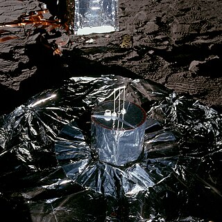
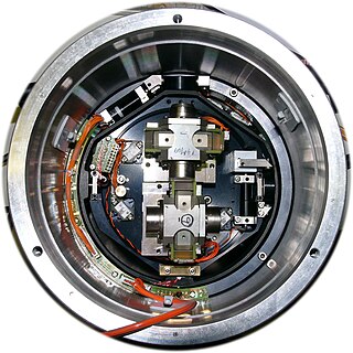
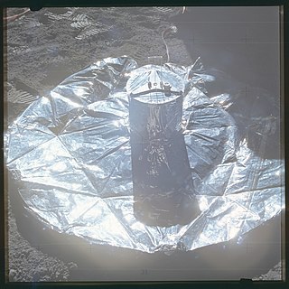
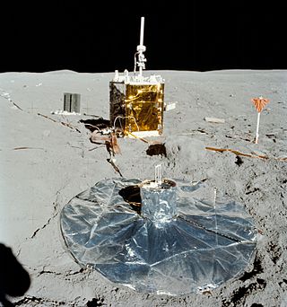
The Apollo 12 Passive Seismic Experiment (PSE) was placed on the lunar surface by the Apollo 12 mission as part of the Apollo Lunar Surface Experiments Package (ALSEP). The PSE was designed to detect vibrations and tilting of the lunar surface and measure changes in gravity at the instrument location. The vibrations are due to internal seismic sources (moonquakes) and external. The primary objective of the experiment was to use these data to determine the internal structure, physical state, and tectonic activity of the Moon. The secondary objectives were to determine the number and mass of meteoroids that strike the Moon and record tidal deformations of the lunar surface.

The Apollo 14 Passive Seismic Experiment (PSE) was placed on the lunar surface on February 5, 1971, as part of the Apollo 14 ALSEP package. The PSE was designed to detect vibrations and tilting of the lunar surface and measure changes in gravity at the instrument location. The vibrations are due to internal seismic sources (moonquakes) and external. The primary objective of the experiment was to use these data to determine the internal structure, physical state, and tectonic activity of the Moon. The secondary objectives were to determine the number and mass of meteoroids that strike the Moon and record tidal deformations of the lunar surface.
Seismic data acquisition is the first of the three distinct stages of seismic exploration, the other two being seismic data processing and seismic interpretation. Seismic acquisition requires the use of a seismic source at specified locations for a seismic survey, and the energy that travels within the subsurface as seismic waves generated by the source gets recorded at specified locations on the surface by what is known as receivers.

The Lunar Seismic Profiling Experiment (LSPE) was a lunar science experiment, deployed by astronauts on the lunar surface in 1972 as part of Apollo 17. The goal of the LSPE was to record the seismic response generated by a variety of sources including the detonation of eight explosive charges, the ascent propulsion system on the lunar module and any natural sources.


