Altavista, Virginia

Last updated

Altavista, Virginia
Altavista, Virginia town sign.JPG
Altavista welcome sign
Seal of Altavista, Virginia.png
Nickname: 
A-Town
Motto(s): 
"Treasured past, Innovative future."
VAMap-doton-Altavista.png
Location of Altavista, Virginia
Coordinates: 37°7′3″N79°17′23″W / 37.11750°N 79.28972°W / 37.11750; -79.28972
CountryUnited States
State Virginia
County Campbell
Planned1905
First settledSeptember 9th, 1907
IncorporatedSeptember 1912
Founded byThe Lane Company
Named for The Lane Family farm
Government
  TypeMayor-council government
  MayorMike Mattox
Area
[1]
  Total5.24 sq mi (13.58 km2)
  Land5.13 sq mi (13.28 km2)
  Water0.11 sq mi (0.29 km2)
Elevation
548 ft (167 m)
Population
 (2020)
  Total3,378
  Estimate 
(2021)
3,396
  Density664.07/sq mi (256.40/km2)
Time zone UTC−5 (Eastern (EST))
  Summer (DST) UTC−4 (EDT)
ZIP code
24517
Area code 434
FIPS code 51-01528 [2]
GNIS feature ID1462426 [3]
Website www.altavistava.gov

Altavista is an incorporated town in Campbell County, Virginia. The town is in the Lynchburg Metropolitan Area, and its population was 3,378 at the 2020 census. [4] It was founded in 1907 by John Edward Lane and Henry L. Lane of the Lane Company, and was chartered on September 1912.

Contents

History

Colonial Period

Pre-colonial

Prior to the colonization of Virginia, the area around what would be Altavista was inhabited by the native Saponi people, in a tribal town that was called "Sapon Town", near what is now the Staunton River. The Saponi cleared out large networks of paths through the forests to connect their villages, inadvertently enabling colonists to come through the area with ease. The more hostile Occaneechi people were also present in the area, and killed some of the first colonizers in the area. Cherokee and Iroquois people also came through the area. [5]

Founding

In 1905, John and Henry Lane's firm, The Lane Brothers Construction Company, had been awarded a contract to build 51 kilometers of railroad between Leesville and The Mansion for the Tidewater Railway Company, which was incorporated by William Nelson Page and Henry Huttleston Rogers. This railroad would also intersect the Southern Railway. [6] [7]

Recognizing the excellent location for a new town, the Lane Company bought 2000 acres of land around the intersection and started planning a town named Lane's Siding. [6] [7] On September 9th, 1907, the first settlers arrived to the town of Lane's Siding in a small red caboose. A firsthand account of the early settlement of the town was written by Mrs. E. G. Fitzgerald:

A photo of one of the first houses in Altavista, ~1907 First house in Altavista.png
A photo of one of the first houses in Altavista, ~1907

When I first came to Altavista there wasn't hardly any body living there. There was the foundation to two stores. Then people began to come and build houses and stores. Then they built a hold and two depots. After awhile some people built a house and used it for a church. They used it for a school house too. Now there are about one thousand people here. [8]

Between July 1908 and May 1909 the town of Lane's Siding which, after a hat toss in one of the company bungalows, [5] was renamed to Altavista after the Lane family farm near Charlottesville, [7] had grown rapidly, with a "$100,000 machine shop, a $20,000 foundry and iron working plant, a $15,000 wood working plant, a $15,000 brick and tile making plant, a banking building and the home office of a $2,000,000 contracting and railway building company, a half dozen stores, a water works plant, an electrict lighting plant, a $30,000 hotel nearing completion, and about fifty residences" all being built in under a year. [9]

On September 1912, the town of Altavista had been incorporated [10]

Sanborn Fire Insurance map of Altavista Sanborn Fire Insurance Map from Altavista, Campbell County, Virginia. LOC sanborn08969 002-2.jpg
Sanborn Fire Insurance map of Altavista

Lane Home Furnishings

In March 1912, John Edward Lane had bought a small box company which had gone bankrupt in an auction for $500, [7] and put his son Edward Hudson Lane in charge of the facility even though he had no experience in the field. Because of how uncertain this new venture was, it was simply incorporated as the Standard Red Cedar Chest Company.

During World War I, the company was contracted to build ammunition boxes for the military. To meet demand, an "efficient assembly system" was introduced at the factory. Although the war was a setback for the company, they were able to sustain itself with capital from the Peoples Bank of Charlottesville, and after the war, they enjoyed great success mass-producing cedar chests. In 1922, the company was renamed to The Lane Company. The company expanded to television cabinets, tables, bedroom furniture, and recliners throughout the mid-20th century. [11] [12]

The Lane Company was most famous for their Lane cedar chests made at the original plant in Altavista. [13] In 1992, The Lane Company's parent company, Furniture Brands International, filed for bankruptcy, and the Lane Company was slated for transfer abroad. In the summer of 2001, the last Lane Cedar Chest was manufactured, and the plant was shut down. [11] The plant is now currently a brownfield, with some of the buildings being used by other companies. In 2006, a fire occured in a vacant section of the plant.

Historic sites

The Avoca Museum Avoca Museum, Altavista, Campbell County, VA 1.JPG
The Avoca Museum

The Avoca Museum and Altavista Downtown Historic District are listed on the National Register of Historic Places. [14]

Government

The current Mayor of Altavista is Mike Mattox, a former teacher and local businessman; the Vice-Mayor is Reggie Bennett. There are five elected members of the Town Council.

Geography

Altavista is located in southwestern Campbell County at 37°7′3″N79°17′23″W / 37.11750°N 79.28972°W / 37.11750; -79.28972 (37.117622, 79.289632). [15] It is bordered to the south by the Roanoke River, which forms the boundary with Pittsylvania County. The town of Hurt is directly to the south across the river.

U.S. Route 29, a four-lane expressway, forms the northern border of the town and provides access from four exits. US 29 leads north 25 miles (40 km) to Lynchburg and south 43 miles (69 km) to Danville.

According to the United States Census Bureau, Altavista has a total area of 5.0 square miles (13.0 km2), of which 4.9 square miles (12.7 km2) is land and 0.12 square miles (0.3 km2), or 2.24%, is water. [4]

Demographics

Historical population
CensusPop.Note
1920 1,206
1930 2,36796.3%
1940 2,91923.3%
1950 3,33214.1%
1960 3,299−1.0%
1970 2,708−17.9%
1980 3,84942.1%
1990 3,686−4.2%
2000 3,425−7.1%
2010 3,4500.7%
2020 3,378−2.1%
U.S. Decennial Census [16]

As of the census [2] of 2000, there were 3,425 people, 1,502 households, and 940 families residing in the town. The population density was 699.9 people per square mile (270.4/km2). There were 1,650 housing units at an average density of 337.2 per square mile (130.3/km2). The racial makeup of the town was 74.25% White, 24.55% African American, 0.09% Native American, 0.20% Asian, 0.32% from other races, and 0.58% from two or more races. Hispanic or Latino of any race were 0.93% of the population.

There were 1,502 households, out of which 26.2% had children under the age of 18 living with them, 42.7% were married couples living together, 16.9% had a female householder with no husband present, and 37.4% were non-families. 34.2% of all households were made up of individuals, and 17.5% had someone living alone who was 65 years of age or older. The average household size was 2.23 and the average family size was 2.86.

In the town, the population was spread out, with 22.5% under the age of 18, 6.7% from 18 to 24, 23.7% from 25 to 44, 25.3% from 45 to 64, and 21.8% who were 65 years of age or older. The median age was 43 years. For every 100 females, there were 77.6 males. For every 100 females age 18 and over, there were 71.8 males.

The median income for a household in the town was $31,818, and the median income for a family was $40,039. Males had a median income of $32,017 versus $22,140 for females. The per capita income for the town was $17,997. About 13.6% of families and 13.5% of the population were below the poverty line, including 14.4% of those under age 18 and 16.7% of those age 65 or over.

Education

The public schools are operated by Campbell County Public Schools.

Altavista High School Team State Championships

Sports teams from Altavista High School have won several state championships in recent years.

Climate

The climate in this area is characterized by hot, humid summers and generally mild to cool winters. According to the Köppen Climate Classification system, Altavista has a humid subtropical climate, abbreviated "Cfa" on climate maps. [17]


Notable people

Related Research Articles

<span class="mw-page-title-main">Waynesboro, Virginia</span> Independent city in Virginia, United States

Waynesboro is an independent city in the Commonwealth of Virginia. It is a principal city of the Staunton-Waynesboro Metropolitan Statistical Area. Waynesboro is located in the Shenandoah Valley and is surrounded by Augusta County. As of the 2020 census, the population was 22,196.

<span class="mw-page-title-main">Radford, Virginia</span> Independent city in Virginia, United States

Radford is an independent city in the U.S. state of Virginia. As of 2020, the population was 16,070 by the United States Census Bureau. For statistical purposes, the Bureau of Economic Analysis combines the city of Radford with neighboring Montgomery County.

<span class="mw-page-title-main">Campbell County, Virginia</span> County in Virginia, United States

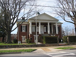
Campbell County is a United States county situated in the south central part of the Commonwealth of Virginia. Located in the Piedmont region of Virginia, Campbell borders the Blue Ridge Mountains. The county seat is Rustburg.

<span class="mw-page-title-main">Collinsville, Alabama</span> Town in Alabama, United States

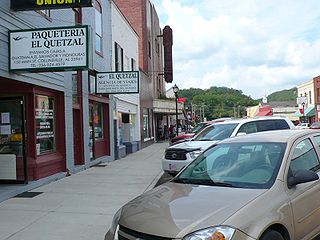
Collinsville is a town in DeKalb and Cherokee counties in the U.S. state of Alabama. It was incorporated in 1887. As of the 2010 census, the population was 1,983.

<span class="mw-page-title-main">Staunton, Indiana</span> Town in Indiana, United States

Staunton is a town in Posey Township, Clay County, Indiana, United States. The population was 534 at the 2010 census. It is part of the Terre Haute Metropolitan Statistical Area.

<span class="mw-page-title-main">Tribune, Kansas</span> City in Greeley County, Kansas

Tribune is a city in and the county seat of Greeley County, Kansas, United States. As of the 2020 census, the population of the city was 772.

<span class="mw-page-title-main">Madison, Kansas</span> City in Greenwood County, Kansas

Madison is a city in Greenwood County, Kansas, United States, along the Verdigris River. As of the 2020 census, the population of the city was 689.

<span class="mw-page-title-main">Burrton, Kansas</span> City in Harvey County, Kansas

Burrton is a city in Harvey County, Kansas, United States. It is named after Isaac T. Burr, former vice-president of the Atchison, Topeka and Santa Fe Railway. As of the 2020 census, the population of the city was 861.

<span class="mw-page-title-main">Little River, Kansas</span> City in Rice County, Kansas

Little River is a city in Rice County, Kansas, United States. As of the 2020 census, the population of the city was 472.

<span class="mw-page-title-main">Brewster, Kansas</span> City in Thomas County, Kansas

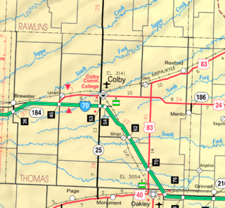
Brewster is a city in Thomas County, Kansas, United States. As of the 2020 census, the population of the city was 291.

<span class="mw-page-title-main">Craigsville, Virginia</span> Town in Virginia, United States

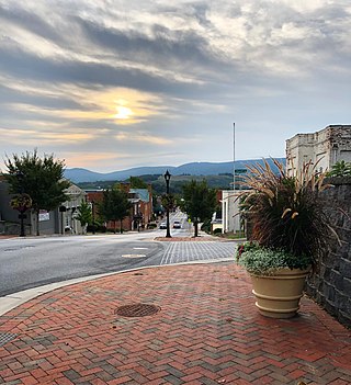
Craigsville is a town in Augusta County, Virginia, United States. The population was 923 at the 2010 census. It is part of the Staunton–Waynesboro Micropolitan Statistical Area.

<span class="mw-page-title-main">Highland Springs, Virginia</span> Census-designated place in Virginia

Highland Springs is a census-designated place (CDP) located in Henrico County, Virginia, United States, 4.3 miles (7 km) east of Richmond. The population was 16,604 at the 2020 census.

<span class="mw-page-title-main">Monterey, Virginia</span> Town in Virginia, United States

Monterey is a town in Highland County, Virginia, United States. The population was 165 at the 2020 census. It is the county seat of Highland County.

<span class="mw-page-title-main">Glasgow, Virginia</span> Town in Virginia, United States

Glasgow is a town in Rockbridge County, Virginia, United States, at the confluence of the James and Maury Rivers. The population was 1,052 at the 2020 census.

<span class="mw-page-title-main">Strasburg, Virginia</span> Town in Virginia, United States

Strasburg is a town in Shenandoah County, Virginia, United States, which was founded in 1761 by Peter Stover. It is the largest town by population in the county and is known for its grassroots art culture, pottery, antiques, and American Civil War history. The population was 7,083 at the 2020 census.

<span class="mw-page-title-main">Cedar Bluff, Virginia</span> Town in Virginia, United States

Cedar Bluff is a town in Tazewell County, Virginia, United States. The population was 1,139 at the 2010 census. It is part of the Bluefield, WV-VA micropolitan area, which has a population of 107,578.

<span class="mw-page-title-main">Jane Lew, West Virginia</span> Town in West Virginia, United States

Jane Lew is a town in Lewis County, West Virginia, United States. The population was 409 at the time of the 2020 census.

<span class="mw-page-title-main">Franklin, West Virginia</span> Town in West Virginia, United States

Franklin is a town in and the county seat of Pendleton County, West Virginia, United States. The population was 486 at the 2020 census. Franklin was established in 1794 and named for Francis Evick, an early settler.

<span class="mw-page-title-main">Mullens, West Virginia</span> City in West Virginia, United States

Mullens is a city in Wyoming County, West Virginia. The population was 1,475 at the time of the 2020 census.

<span class="mw-page-title-main">Clarksville, Virginia</span> Town in Virginia, United States

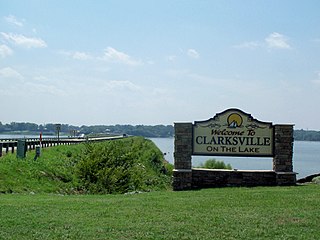
Clarksville is a town in Mecklenburg county in the U.S. state of Virginia, near the southern border of the commonwealth. The population was 1,139 at the 2010 census. Since the town has numerous buildings of the 18th-, 19th-, and early 20th-century architecture, the downtown area of Clarksville has been designated a Historic District on the National Register of Historic Places and Virginia's Historic Register. Clarksville claims the title of Virginia's only lakeside town. Nearby the town of Clarksville is Occoneechee State Park.

References

  1. "2019 U.S. Gazetteer Files". United States Census Bureau. Retrieved August 7, 2020.
  2. 1 2 "U.S. Census website". United States Census Bureau . Retrieved January 31, 2008.
  3. "US Board on Geographic Names". United States Geological Survey. October 25, 2007. Retrieved January 31, 2008.
  4. 1 2 "Geographic Identifiers: 2010 Demographic Profile Data (G001): Altavista town, Virginia". U.S. Census Bureau, American Factfinder. Retrieved August 19, 2015.[ dead link ]
  5. 1 2 Popek, Diane (1984). TRACKS Along the Staunton: A History of Leesville, Lynch Station, Hurt, & Altavista. Altavista Printing Company. ASIN   B0006YPLEK.
  6. 1 2 'Founding of Altavista', Staunton River Memorial Library
  7. 1 2 3 4 Carpenter, Robert (2007). A Pictorial History of Altavista, Virginia (1907-2007). Altavista, VA: The Altavista Town Council. ASIN   B008J2J6XI.
  8. Fitzgerald, E. G., "Altavista", 1957 (The Altavista Journal, 10/20/1982)
  9. "Unique Altavista A Remarkable Town". The Altavista Journal. Vol. 1. October 23, 1909. p. 1.
  10. "Charter". 1936. c. 419.
  11. 1 2 "Lane Cedar Chest". Virginia Museum of History & Culture. Retrieved May 27, 2024.{{cite web}}: CS1 maint: url-status (link)
  12. "Lane Company History | Lane Cedar Box.com". lanecedarbox. Retrieved May 27, 2024.
  13. Schleining, Lon (2003). Treasure Chests: The Legacy of Extraordinary Boxes. Taunton Press. p. 54. ISBN   1-56158-651-X.
  14. "National Register Information System". National Register of Historic Places . National Park Service. July 9, 2010.
  15. "US Gazetteer files: 2010, 2000, and 1990". United States Census Bureau. February 12, 2011. Retrieved April 23, 2011.
  16. "Census of Population and Housing". Census.gov. Retrieved June 4, 2015.
  17. Climate Summary for Altavista, Virginia