Ridgeway, Virginia

Last updated

Ridgeway, Virginia
VAMap-doton-Ridgeway.PNG
Location of Ridgeway, Virginia
Coordinates: 36°34′45″N79°51′36″W / 36.57917°N 79.86000°W / 36.57917; -79.86000
CountryUnited States
State Virginia
County Henry
Area
[1]
  Total0.95 sq mi (2.47 km2)
  Land0.95 sq mi (2.47 km2)
  Water0.00 sq mi (0.00 km2)
Elevation
948 ft (289 m)
Population
 (2010)
  Total742
  Estimate 
(2019) [2]
693
  Density725.65/sq mi (280.21/km2)
Time zone UTC−5 (Eastern (EST))
  Summer (DST) UTC−4 (EDT)
ZIP code
24148
Area code 276
FIPS code 51-67208 [3]
GNIS feature ID1473206 [4]

Ridgeway is a town in Henry County, Virginia, United States. The population was 742 at the 2010 census. [5] It is part of the Martinsville Micropolitan Statistical Area. Martinsville Speedway, a NASCAR racetrack, is located between Ridgeway and the Martinsville city limits.

Contents

History

Historic marker for William Byrd's camp on his expedition to survey the Dividing Line, Henry County, Virginia, 1728 William Byrd's Camp November 1728 Historic Marker Henry County Virginia.JPG
Historic marker for William Byrd's camp on his expedition to survey the Dividing Line, Henry County, Virginia, 1728

Approximately three miles south of Ridgeway in Henry County on U.S. Route 220 is a Virginia State historic marker noting the passing of the surveying party of William Byrd II, who moved through the area in 1728 on his expedition to survey the dividing line between Virginia and North Carolina.

Belleview and Ingleside are listed on the National Register of Historic Places. [6]

Geography

Ridgeway is located in southern Henry County at 36°34′45″N79°51′36″W / 36.57917°N 79.86000°W / 36.57917; -79.86000 (36.579148, 79.860078). [7] U.S. Route 220 passes through the west side of the town, leading north 8 miles (13 km) to Martinsville and 59 miles (95 km) to Roanoke; and south 40 miles (64 km) to Greensboro, North Carolina. Virginia State Route 87 passes through the center of Ridgeway and leads southeast 8 miles (13 km) to Eden, North Carolina.

According to the United States Census Bureau, Ridgeway has a total area of 0.97 square miles (2.5 km2), all of it land. [5] The north side of Ridgeway drains via Marrowbone Creek and Reds Creek to the Smith River, a tributary of the Dan River, while the south side of town drains to Matrimony Creek, also a tributary of the Dan River.

Demographics

Historical population
CensusPop.Note
1890 236
1900 33240.7%
1910 39318.4%
1920 320−18.6%
1930 35912.2%
1940 42217.5%
1950 4404.3%
1960 52419.1%
1970 62419.1%
1980 85837.5%
1990 752−12.4%
2000 7753.1%
2010 742−4.3%
2019 (est.)693 [2] −6.6%
U.S. Decennial Census [8]

As of the census [3] of 2000, there were 775 people, 310 households, and 221 families living in the town. The population density was 825.3 people per square mile (318.3/km2). There were 327 housing units at an average density of 348.2 per square mile (134.3/km2). The racial makeup of the town was 79.87% White, 16.00% African American, 2.45% Asian, 1.03% from other races, and 0.65% from two or more races. Hispanic or Latino of any race were 2.32% of the population.

There were 310 households, out of which 31.3% had children under the age of 18 living with them, 54.2% were married couples living together, 13.2% had a female householder with no husband present, and 28.4% were non-families. 26.1% of all households were made up of individuals, and 10.6% had someone living alone who was 65 years of age or older. The average household size was 2.50 and the average family size was 3.01.

In the town, the population was spread out, with 25.4% under the age of 18, 6.1% from 18 to 24, 27.7% from 25 to 44, 28.4% from 45 to 64, and 12.4% who were 65 years of age or older. The median age was 39 years. For every 100 females, there were 86.3 males. For every 100 females age 18 and over, there were 80.6 males.

The median income for a household in the town was $34,196, and the median income for a family was $39,500. Males had a median income of $27,109 versus $21,146 for females. The per capita income for the town was $16,054. About 12.1% of families and 12.0% of the population were below the poverty line, including 12.0% of those under age 18 and 15.3% of those age 65 or over.

Notable people

Related Research Articles

<span class="mw-page-title-main">Henry County, Virginia</span> County in Virginia, United States

Henry County is a county located in the U.S. state of Virginia. As of the 2020 census, the population was 50,948. The county seat is usually identified as Martinsville; however, the administration building, county courthouse, and Henry County Sheriff's Office are located on Kings Mountain Road in Collinsville.The Henry County Adult Detention Center is located on DuPont Road in Martinsville.

<span class="mw-page-title-main">Trafalgar, Indiana</span> Town in Indiana, United States

Trafalgar is a town in Nineveh and Hensley townships, Johnson County, Indiana, United States. The population was 1,101 at the 2010 census.

<span class="mw-page-title-main">McKenney, Virginia</span> Town in Virginia, United States

McKenney is an incorporated town in Dinwiddie County, Virginia, United States. The population was 483 at the 2010 census.

<span class="mw-page-title-main">Halifax, Virginia</span> Town in Virginia, United States

Halifax is a town in Halifax County, Virginia, United States, along the Banister River. The population was 1,309 at the 2010 census. It is the county seat of Halifax County.

<span class="mw-page-title-main">Bassett, Virginia</span> CDP in Virginia, United States

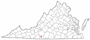
Bassett is a census-designated place (CDP) in Henry County, Virginia, United States. The population was 1,100 at the 2010 census. It is part of the Martinsville Micropolitan Statistical Area. The town was founded along a rail line by the same family that later started Bassett Furniture. Bassett Furniture's headquarters have remained in Bassett since it began in 1902.

<span class="mw-page-title-main">Collinsville, Virginia</span> CDP in Virginia, United States

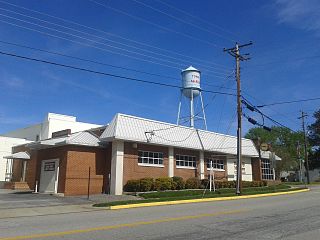
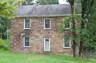
Collinsville is a census-designated place (CDP) in Henry County, Virginia, United States. The population was 7,335 at the 2010 census, which was down from the 7,777 reported in 2000. It is part of the Martinsville Micropolitan Statistical Area. Collinsville is also where the administration building and county courthouse of Henry County are located.

<span class="mw-page-title-main">Fieldale, Virginia</span> CDP in Virginia, United States

Fieldale is a census-designated place (CDP) in Henry County, Virginia, United States. The population was 879 at the 2010 census. It is part of the Martinsville Micropolitan Statistical Area.

<span class="mw-page-title-main">Horsepasture, Virginia</span> CDP in Virginia, United States

Horsepasture is a census-designated place (CDP) in Henry County, Virginia, United States. The population was 2,227 at the 2010 census. It is part of the Martinsville Micropolitan Statistical Area.

<span class="mw-page-title-main">Laurel Park, Virginia</span> CDP in Virginia, United States

Laurel Park is a census-designated place (CDP) in Henry County, Virginia, United States. The population was 675 at the 2010 census. It is part of the Martinsville Micropolitan Statistical Area.

<span class="mw-page-title-main">Oak Level, Virginia</span> CDP in Virginia, United States

Oak Level is a census-designated place (CDP) in Henry County, Virginia, United States. The population was 857 at the 2010 census. It is part of the Martinsville Micropolitan Statistical Area.

Villa Heights is a census-designated place (CDP) in Henry County, Virginia, United States. The population was 717 at the 2010 census. It is part of the Martinsville Micropolitan Statistical Area.

<span class="mw-page-title-main">Hurt, Virginia</span> Town in Virginia, United States

Hurt is a town in Pittsylvania County, Virginia, United States. Population was 1,269 at the 2020 census. It is included in the Danville, Virginia Metropolitan Statistical Area.

<span class="mw-page-title-main">Gilbert, West Virginia</span> Town in West Virginia, United States

Gilbert is a town in Mingo County, West Virginia, United States, along the Guyandotte River. The population was 333 at the 2020 census. Gilbert was incorporated in 1918 and named for Gilbert Creek, which derives its name from the name of an early traveler in the area who was killed by Native Americans. Gilbert is known nationwide for the Hatfield-McCoy ATV Trails that are located in the area. There are a number of lodges and restaurants in Gilbert.

<span class="mw-page-title-main">Granville, West Virginia</span> Town in West Virginia

Granville is a town in Monongalia County, West Virginia, United States. The population was 1,355 at the 2020 census. It is included in the Morgantown metropolitan area.

<span class="mw-page-title-main">Albright, West Virginia</span> Town in West Virginia, United States

Albright is a town in central Preston County, West Virginia, United States, along the Cheat River. The population was 260 at the 2020 census. A former coal town, it is part of the Morgantown metropolitan area.

<span class="mw-page-title-main">Bruceton Mills, West Virginia</span> Town in West Virginia, United States

Bruceton Mills is a town in northern Preston County, West Virginia, United States, along Big Sandy Creek. The population was 64 at the 2020 census, making it the second-least populous town in West Virginia, after Thurmond. It is part of the Morgantown metropolitan area.

<span class="mw-page-title-main">Reedsville, West Virginia</span> Town in West Virginia, United States

Reedsville is a town in western Preston County, West Virginia, United States. The population was 530 at the 2020 census. It is part of the Morgantown metropolitan area.

<span class="mw-page-title-main">Reedy, West Virginia</span> Town in West Virginia, United States

Reedy is a town in Roane County, West Virginia, United States. The population was 152 at the 2020 census.

<span class="mw-page-title-main">New Martinsville, West Virginia</span> City in West Virginia, United States

New Martinsville is a city in and the county seat of Wetzel County, West Virginia, United States, along the Ohio River. The population was 5,186 at the 2020 census.

<span class="mw-page-title-main">Martinsville, Virginia micropolitan area</span>

The Martinsville Micropolitan Statistical Area is a United States Micropolitan Statistical Area (USA) in Virginia, as defined by the Office of Management and Budget (OMB) as of June, 2003. As of the 2000 census, the μSA had a population of 73,346.

References

  1. "2019 U.S. Gazetteer Files". United States Census Bureau. Retrieved August 7, 2020.
  2. 1 2 "Population and Housing Unit Estimates". United States Census Bureau. May 24, 2020. Retrieved May 27, 2020.
  3. 1 2 "U.S. Census website". United States Census Bureau . Retrieved January 31, 2008.
  4. "US Board on Geographic Names". United States Geological Survey. October 25, 2007. Retrieved January 31, 2008.
  5. 1 2 "Geographic Identifiers: 2010 Census Summary File 1 (G001): Ridgeway town, Virginia". American Factfinder. U.S. Census Bureau. Archived from the original on February 13, 2020. Retrieved March 22, 2018.
  6. "National Register Information System". National Register of Historic Places . National Park Service. July 9, 2010.
  7. "US Gazetteer files: 2010, 2000, and 1990". United States Census Bureau. February 12, 2011. Retrieved April 23, 2011.
  8. "Census of Population and Housing". Census.gov. Retrieved June 4, 2015.