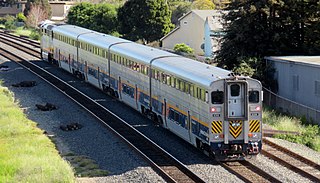
The San Joaquins is a passenger train service operated by Amtrak in California's San Joaquin Valley. Six daily round trips run between its southern terminus at Bakersfield and Stockton, with onward service to Sacramento and Oakland.

California High-Speed Rail is a publicly funded high-speed rail system being developed in the U.S. state of California by the California High-Speed Rail Authority. It was authorized by a statewide ballot proposal called Proposition 1A. It is intended to reduce travel times in the state, particularly between the major urban areas of the north and the south. The system is also intended to reduce pollution and carbon emissions, ease highway and air traffic congestion, and boost the state's economy, particularly in the Central Valley region.
The 91/Perris Valley Line, formerly known as the 91 Line, is a commuter rail route operated by Metrolink that runs from Los Angeles to Perris in Southern California, mostly paralleling State Route 91 between Riverside-Downtown and Buena Park stations. Operating since May 2002, the route runs on the Southern Transcon line owned by BNSF Railway, as well as the Riverside County Transportation Commission-owned San Jacinto Branch Line. Services are primarily operated along the entire route between L.A. Union Station and Perris–South, while some trips use Riverside–Downtown as a terminus.

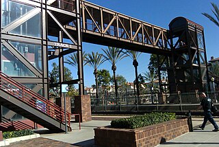
The Regional Connector Transit Project constructed a 1.9-mile (3.1 km) light rail tunnel for the Los Angeles Metro Rail system in Downtown Los Angeles. It connected the A and E lines with the former L Line. The A and E lines previously both terminated at 7th Street/Metro Center station, coming from Long Beach and Santa Monica, respectively, while the L Line ran through Little Tokyo/Arts District to either Azusa or East Los Angeles. Now the A and E lines continue together through new stations at Grand Avenue Arts/Bunker Hill, Historic Broadway, and Little Tokyo/Arts District. From there, they diverge on the former L Line toward Azusa and East Los Angeles, respectively. The project provides a one-seat ride into the core of Downtown for passengers on those lines who previously needed to transfer, thus reducing or altogether eliminating many transfers of passengers traveling across the region via Downtown Los Angeles.

Madera station is an unstaffed train station near Madera, California, United States that is served by San Joaquins trains, which run between Oakland or Sacramento and Bakersfield, California.
Mill Creek is a linear park located in Bakersfield, California. It runs along the Kern Island Canal between Golden State Avenue and California Avenue in downtown, although there is a gap between 19th Street and the BNSF railroad yard. The center of the park is Central Park, the only park in downtown. The park contains a lake with spray fountains and the “Mill Creek” bridge. It is also home to the Bakersfield Museum of Art and the Bakersfield Community House.

Kern County’s transportation system was quoted as the “unseen industry.” Located at the southern end of the San Joaquin Valley, the county is at a prime location to ship goods west to the central coast, south to ports in Los Angeles, and east to corridors that connect to the rest of the country. It is also on major corridors that link to all northern points.

The construction of the California High-Speed Rail system is an undertaking by the California High-Speed Rail Authority. The project is expected to span about 800 miles (1,300 km) and will be completed in two phases:

The California High-Speed Rail Authority was established in 1996 after decades of advocacy for building a high speed rail system in California. The passage of Proposition 1A in 2008, followed by the awarding of federal stimulus funds in 2010, established the initial funding for the California High-Speed Rail system. Construction contracts began to be awarded in 2013, and the groundbreaking ceremony for initial construction was held on January 6, 2015.
Kings–Tulare Regional Station is a planned California High-Speed Rail station serving Kings County and Tulare County, California. It will be located near the intersection of Hanford Expressway and Central Valley Highway, just east of the city limits of Hanford and less than 20 miles (32 km) west of the larger city of Visalia. The construction of the station has been controversial, with Tulare County supporting the station while Kings County, where the station would be located, has strongly opposed the entire California High-Speed Rail project.

Fresno is a California High-Speed Rail station being constructed in Fresno, California. The first purpose-built high speed rail station in the United States, it is part of the system's Initial Construction Segment. The facility is located in Downtown Fresno at H Street between Fresno and Tulare Streets, and is being built as an expansion of the adjacent historic Fresno Southern Pacific Depot.
Merced station is a proposed California High-Speed Rail station in Merced, California, located in Downtown Merced. The environmentally approved site is on Martin Luther King Jr. Way near the interchange with Route 99/59, placing it about 7 blocks south from the existing Merced Amtrak station. The station was initially intended to be the northern terminus of the system's Initial Construction Segment. As of April 2022 the California High-Speed Rail Authority is studying an alternative location proposed by the City of Merced and other stakeholders, 8 blocks to the west-northwest along 15th Street, between O Street and R Street. The high-speed rail line will run on the south side of the Union Pacific Railroad right-of-way at these locations.
The Fresno River Viaduct is a bridge to carry California High-Speed Rail over Route 145, the Fresno River, and Raymond Road in Madera County, California.
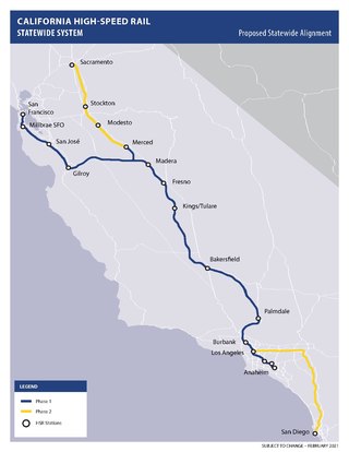
The California High-Speed Rail system will be built in two major phases. Phase I, about 520 miles (840 km) long using high-speed rail through the Central Valley, will connect San Francisco to Los Angeles. In Phase 2, the route will be extended in the Central Valley north to Sacramento, and from east through the Inland Empire and then south to San Diego. The total system length will be about 800 miles (1,300 km) long. Phase 2 currently has no timeline for completion.
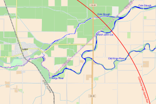
The Kings River Viaduct is a planned series of bridges and embankments carrying California High-Speed Rail over the Kings River in Fresno County and Kings County, California. The site is between the Fresno and Kings–Tulare stations, roughly 4 miles (6.4 km) east of Laton and 8 miles (13 km) north of Hanford. The structure is planned to be over 2 miles (3.2 km) long because three river channels must be crossed, two of which were created by floods in the 1860s.
The Pacheco Pass Tunnels are a planned set of tunnels to carry California High-Speed Rail across the Diablo Range in the vicinity of Pacheco Pass east of Gilroy, California. The tunnels will constitute the first mountain crossing constructed as part of California High-Speed Rail, connecting the San Francisco Bay Area and Central Valley portions of the system.
The Southeast Gateway Line, formerly called the West Santa Ana Branch Transit Corridor, is a planned light rail line, mostly following the Pacific Electric's historic West Santa Ana Branch, connecting Downtown Los Angeles to the city of Artesia, along with other cities in southeastern Los Angeles County.

The Stockton Subdivision is a railroad line in the U.S. state of California owned by the BNSF Railway. It runs from the Port of Richmond, where trains interchange with the Richmond Pacific Railroad, to Fresno where the railway continues south as the Bakersfield Subdivision or the Union Pacific Fresno Subdivision. The line was originally constructed by the San Francisco and San Joaquin Valley Railroad in the late 1890s before being acquired by the Atchison, Topeka and Santa Fe Railway and becoming its Valley Subdivision. BNSF spent $17.5 million to upgrade track, bridges, and crossings along the line in 2005.
Burbank Airport station is a proposed California High-Speed Rail station in Burbank, California, to be located at the Hollywood Burbank Airport adjacent to and just west of that facility's proposed replacement passenger terminal, which will be built in the northeast quadrant of the airfield. The site for the rail station is bounded by Cohasset Street to the north, Winona Avenue on the south, and Hollywood Way along the eastern end of the airport property.

In addition to the direct reduction in travel times the HSR project will produce, there are also economic and environmental impacts of the high-speed rail system. These were also specifically noted in Proposition 1A at the time the project sought authorization from the voters of the state in 2008. The anticipated benefits apply both generally to the state overall, as well as to the regions the train will pass through, and to the areas immediately around the train stations.

