The San Joaquins is a passenger train service operated by Amtrak in California's San Joaquin Valley. Six daily round trips run between its southern terminus at Bakersfield and Stockton, with onward service to Sacramento and Oakland.

California High-Speed Rail (CAHSR) is a publicly funded high-speed rail system being developed in California by the California High-Speed Rail Authority. Phase 1, about 494 miles (795 km) long, is planned to run from San Francisco to Los Angeles and Anaheim via the Central Valley, and is partially funded and under construction. A proposed Phase 2 would extend the system north to Sacramento and south to San Diego, for a total of 776 miles (1,249 km). The project was authorized by a 2008 statewide ballot to connect the state's major urban areas and reduce intercity travel times. Phase 1 targets a travel time of 2 hours and 40 minutes from San Francisco to Los Angeles, compared to about nine hours on existing Amtrak service.

Central California is generally thought of as the middle third of the U.S. state of California, north of Southern California and south of Northern California. It includes the northern portion of the San Joaquin Valley, part of the Central Coast, the central hills of the California Coast Ranges and the foothills and mountain areas of the central Sierra Nevada.

The Fresno River is a river in Central California and a major tributary of the San Joaquin River. It runs approximately 83 miles (134 km) from the Sierra Nevada Range to the San Joaquin River if measured from the source of Rainier Creek, near Raymond Mountain in Yosemite National Park. Although called the 'Fresno' River, it is one of the largest and longest river systems in Madera County.

The Medway Viaducts are three bridges or viaducts that cross the River Medway between Cuxton and Borstal in north Kent, England. The two road bridges carry the M2 motorway carriageways. The other viaduct carries the High Speed 1 railway line linking London and the Channel Tunnel. All three bridges pass over the Medway Valley Line.

Madera station is an unstaffed train station near Madera, California, United States that is served by San Joaquins trains, which run between Oakland or Sacramento and Bakersfield, California.
Fairmead is a census-designated place in Madera County, California, United States. It is located 11 miles (18 km) northwest of Madera, at an elevation of 253 feet (77 m), and bordered to the northwest by Chowchilla. The population was 1,235 at the 2020 census.
The construction of the California High-Speed Rail system is an undertaking by the California High-Speed Rail Authority. The project is expected to span about 800 miles (1,300 km) and will be completed in two phases:
Bakersfield station is a proposed California High-Speed Rail station in Bakersfield, California. The station is part of the initial construction segment.
Kings–Tulare Regional Station is a planned California High-Speed Rail station serving Kings County and Tulare County, California. It will be located near the intersection of Hanford Expressway and Central Valley Highway, just east of the city limits of Hanford and less than 20 miles (32 km) west of the larger city of Visalia. The construction of the station has been controversial, with Tulare County supporting the station while Kings County, where the station would be located, has strongly opposed the entire California High-Speed Rail project.

Fresno is a California High-Speed Rail station being constructed in Fresno, California. The first purpose-built high speed rail station in the United States, it is part of the system's Initial Construction Segment. The facility is located in Downtown Fresno at H Street between Fresno and Tulare Streets, and is being built as an expansion of the adjacent historic Fresno Southern Pacific Depot.
Merced station is a proposed California High-Speed Rail station in Merced, California, located in Downtown Merced. The originally proposed site was to have been located at ground level on Martin Luther King Jr. Way near the interchange with Route 99/59, placing it about 7 blocks south from the existing Merced Amtrak station. The station was initially intended to be the northern terminus of the system's Initial Construction Segment. An alternative location for a fully elevated station proposed by the City of Merced and other stakeholders, 8 blocks to the west-northwest along 15th Street, between O Street and R Street was approved after a supplemental environmental review. The high-speed rail line will run on the south side of the Union Pacific Railroad right-of-way.

The East River Bridge is a multi-span bridge in Sheet Harbour, Nova Scotia that carries Trunk 7 and the Marine Drive scenic route over the Northeast Arm of Sheet Harbour. The bridge is 183 m (600 ft) in length and was constructed from September 2014 to December 2015. It was opened on December 17, 2015 to pedestrians, with a bridge walk commemorating the closing of the old bridge and the opening of the new bridge. The bridge was opened to vehicles the day after. It replaced a green steel arch bridge of the same name that was built in 1956 immediately north of the current bridge. The previous bridge had a span of 213 m (699 ft) and shared engineering ties with the Angus L. MacDonald Bridge in Halifax. Nova Scotia was considering repairs to the old bridge, but they ultimately elected to construct a new bridge instead. The current bridge was designed without overhead arches, unlike its predecessor, as the construction cost would have been doubled.
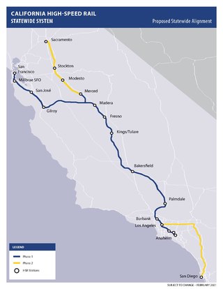
The California High-Speed Rail system will be built in two major phases. Phase I, about 520 miles (840 km) long using high-speed rail through the Central Valley, will connect San Francisco to Los Angeles. In Phase 2, the route will be extended in the Central Valley north to Sacramento, and from east through the Inland Empire and then south to San Diego. The total system length will be about 800 miles (1,300 km) long. Phase 2 currently has no timeline for completion.

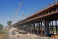
The San Joaquin River Viaduct is a bridge built to carry California High-Speed Rail over the San Joaquin River.
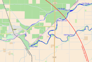
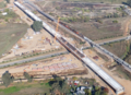
The Kings River Viaduct is a planned series of bridges and embankments carrying California High-Speed Rail over the Kings River in Fresno County and Kings County, California. The site is between the Fresno and Kings–Tulare stations, roughly 4 miles (6.4 km) east of Laton and 8 miles (13 km) north of Hanford. The structure is planned to be over 2 miles (3.2 km) long because three river channels must be crossed, two of which were created by floods in the 1860s.
The Ulla Viaduct is a composite truss bridge that spans the Ulla river, in Galicia, northern Spain. It is a part of the Atlantic Axis, a high-speed rail line.
The Pacheco Pass Tunnels are a planned set of tunnels to carry California High-Speed Rail across the Diablo Range in the vicinity of Pacheco Pass east of Gilroy, California. The tunnels will constitute the first mountain crossing constructed as part of California High-Speed Rail, connecting the San Francisco Bay Area and Central Valley portions of the system.

The Stockton Subdivision is a railroad line in the U.S. state of California owned by the BNSF Railway. It runs from the Port of Richmond, where trains interchange with the Richmond Pacific Railroad, to Fresno where the railway continues south as the Bakersfield Subdivision or the Union Pacific Fresno Subdivision. The line was originally constructed by the San Francisco and San Joaquin Valley Railroad in the late 1890s before being acquired by the Atchison, Topeka and Santa Fe Railway and becoming its Valley Subdivision. BNSF spent $17.5 million to upgrade track, bridges, and crossings along the line in 2005.

In addition to the direct reduction in travel times the HSR project will produce, there are also economic and environmental impacts of the high-speed rail system. These were also specifically noted in Proposition 1A at the time the project sought authorization from the voters of the state in 2008. The anticipated benefits apply both generally to the state overall, as well as to the regions the train will pass through, and to the areas immediately around the train stations.