
Oatfield is an unincorporated community and census-designated place in Clackamas County, Oregon, United States. It is in the Portland metropolitan area. As of the 2010 census, the population of the CDP was 13,415.

Winchester Bay, formerly Umpqua City, is an unincorporated community in Douglas County, Oregon, United States. For statistical purposes, the United States Census Bureau has defined Winchester Bay as a census-designated place (CDP). The census definition of the area may not precisely correspond to local understanding of the area with the same name. The population of the CDP was 382 at the 2010 census. The community of Umpqua City was established in 1850.

White City is an unincorporated community and census-designated place (CDP) in Jackson County, Oregon, United States. The population was 7,975 at the 2010 census, up from 5,466 at the 2000 census. White City is about 9 miles (14 km) north of the center of Medford and 4 miles (6 km) south of Eagle Point.

South Lebanon is a census-designated place (CDP) in Linn County, Oregon, United States, comprising unincorporated land on the south side of the city of Lebanon. The population was 1,005 at the 2010 census. The population and area of the CDP decreased between 2000 and 2010 as the city limits of Lebanon expanded southward.

Manzanita is a coastal city in Tillamook County, Oregon, United States. It is located on U.S. Route 101 about 25 miles (40 km) equidistant from Seaside to the north and Tillamook to the south. The population was 603 at the 2020 census.
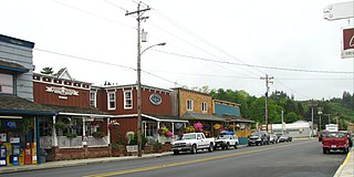
Nehalem is a city in Tillamook County, Oregon, United States. Incorporated in 1889, the city lies along the Nehalem River and Nehalem Bay near the Pacific Ocean. It is bisected by U.S. Route 101. The population was 355 at the 2020 census.

Rowena is an unincorporated community in Wasco County, Oregon, United States. For statistical purposes, the United States Census Bureau has defined Rowena as a census-designated place (CDP). The census definition of the area may not precisely correspond to local understanding of the area with the same name. The population was 187 at the 2010 census.

Garden Home-Whitford is a census-designated place (CDP) consisting of the neighborhoods of Garden Home and the smaller Whitford area in Washington County, Oregon, United States. They are located in the southwest hills of Portland, near Beaverton. As of the 2020 census, the CDP population was 7,081.
Leola is a census-designated place (CDP) in Lancaster County, Pennsylvania, United States. It includes the unincorporated communities of Leola, Leacock, and Bareville, and prior to 2010 was known as the Leacock-Leola-Bareville census-designated place. Originally named "Mechanicsburg", its present name is a portmanteau of "Leacock" and the "Glenola" train station that once served the town. As of the 2010 census, the population of the CDP was 7,214.

Days Creek is an unincorporated community and census-designated place in Douglas County, Oregon, United States. At the 2010 census it had a population of 272.
Merlin is an unincorporated community and census-designated place (CDP) in Josephine County, Oregon, United States. As of the 2010 census it had a population of 1,615. The area is known for sport fishing and whitewater rafting on the Rogue River. Merlin's ZIP code is 97532.

Stafford is an unincorporated community, classified as a hamlet, in Clackamas County, Oregon, United States. It is a census-designated place (CDP), with a population of 1,577 as of the 2010 census. The community covers approximately 15.7 km2 located in a rough triangle south of Lake Oswego, east of Tualatin, and west of West Linn. Students in the area attend the schools of the West Linn-Wilsonville School District.

Bayside is a census-designated place (CDP) in Accomack County, Virginia, United States. It was first listed as a CDP in 2010. Per the 2020 census, the population was 107.
Glasgow is an unincorporated community in Coos County, Oregon, United States. For statistical purposes, the United States Census Bureau has defined Glasgow as a census-designated place (CDP). The census definition of the area may not precisely correspond to local understanding of the area with the same name. As of the 2010 census the Glasgow CDP had a population of 763. The place name for Glasgow in the Coos language is Kdet.
Foots Creek is an unincorporated community and census-designated place (CDP) in Jackson County, in the U.S. state of Oregon. It lies along Oregon Route 99 near the mouth of Foots Creek, where it empties into the Rogue River. Interstate 5 and Valley of the Rogue State Park are on the side of the river opposite Foots Creek.
Seventh Mountain is an unincorporated community and census-designated place (CDP) in Deschutes County, in the U.S. state of Oregon. The community lies along the west bank of the Deschutes River southwest of Bend.
Pronghorn is a census-designated place (CDP) and resort community in Deschutes County, Oregon, United States. It is part of the Bend, Oregon Metropolitan Statistical Area. The residential population was 34 at the 2010 census. It comprises the Pronghorn Golf Club, located 4 miles (6 km) south of Redmond.
Tetherow is a census-designated place (CDP) in Deschutes County, Oregon, United States. It is part of the Bend, Oregon Metropolitan Statistical Area. The population was 45 at the 2010 census.
River Point is an unincorporated community and census-designated place (CDP) in Clatsop County, Oregon, United States. It was first listed as a CDP prior to the 2020 census.
Barnesdale is an unincorporated community and census-designated place (CDP) in Tillamook County, Oregon, United States. It was first listed as a CDP prior to the 2020 census.


