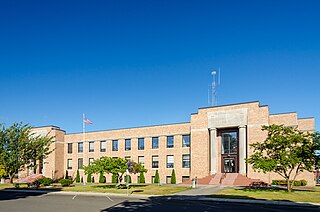
Tillamook County is one of the 36 counties in the U.S. state of Oregon. As of the 2020 census, the population was 27,390. The county seat is Tillamook. The county is named for the Tillamook or Killamook people, a Native American tribe who were living in the area in the early 19th century at the time of European American settlement. The county is located within Northwest Oregon.

The Tillamook County Creamery Association (TCCA) is a farmer-owned dairy cooperative headquartered in Tillamook County, Oregon, United States. The association manufactures and sells dairy products under the "Tillamook" brand name. Its main facility is the Tillamook Creamery, located two miles north of the city of Tillamook on U.S. Route 101.

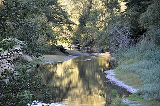
The Wilson River, about 33 miles (53 km) long, flows from the Northern Oregon Coast Range to Tillamook Bay in the U.S. state of Oregon. Formed by the confluence of its Devil's Lake Fork and its South Fork, it runs generally west through the Tillamook State Forest to its mouth near the city of Tillamook. It is one of five rivers—the Tillamook, the Trask, the Wilson, the Kilchis, and the Miami—that flow into the bay.
The Miami River is a stream, approximately 13 miles (21 km) long, on the coast of northwest Oregon in the United States. It drains a mountainous timbered region of the Northern Oregon Coast Range west of Portland, into Pacific Ocean.

The Nehalem River is a river on the Pacific coast of northwest Oregon in the United States, approximately 119 miles (192 km) long. It drains part of the Northern Oregon Coast Range northwest of Portland, originating on the east side of the mountains and flowing in a loop around the north end of the range near the mouth of the Columbia River. Its watershed of 855 square miles (2,210 km2) includes an important timber-producing region of Oregon that was the site of the Tillamook Burn. In its upper reaches it flows through a long narrow valley of small mountain communities but is unpopulated along most of its lower reaches inland from the coast.

The Clatsop is a small tribe of Chinookan-speaking Native Americans in the Pacific Northwest of the United States. In the early 19th century they inhabited an area of the northwestern coast of present-day Oregon from the mouth of the Columbia River south to Tillamook Head, Oregon.
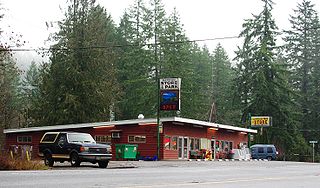
Idiotville is a ghost town in Tillamook County, Oregon, United States, near the mouth of Idiot Creek on the Wilson River, on the route of Oregon Route 6. Idiotville's elevation is 1,200 feet.

Oregon Route 6 is a state highway in the U.S. state of Oregon that runs between the city of Tillamook on the Oregon Coast, to the Willamette Valley, near Banks. OR 6 traverses the Wilson River Highway No. 37 of the Oregon state highway system, named after the river paralleling the highway's western segment.

Gales Creek is an unincorporated community in Washington County, Oregon, United States on Oregon Route 8 northwest of Forest Grove in the foothills of the Oregon Coast Range.
Glenwood is an unincorporated community in Washington County, Oregon, United States, northwest of Forest Grove on Oregon Route 6.

Wilkesboro is an unincorporated community in Washington County, Oregon, United States. It is located on Oregon Route 6, one mile east of Banks.

Dolph is an unincorporated community in Tillamook County, Oregon, United States, near the Yamhill County line. It lies at the junction of Oregon Route 22 and Oregon Route 130 between Grande Ronde and Hebo, on the Little Nestucca River. It is within the Siuslaw National Forest in the Northern Oregon Coast Range.
The Oregon Youth Authority (OYA) is a state agency of Oregon, headquartered in Suite 500 of the 530 Center St. NE building in Salem. The agency operates juvenile corrections.
Mohler is an unincorporated community in Tillamook County, Oregon, United States. It is east of U.S. Route 101 on Oregon Route 53 along the Nehalem River.
Lees Camp is an unincorporated community in Tillamook County, Oregon, United States. It is along Oregon Route 6 about 25 miles (40 km) northeast of Tillamook at the confluence of the Wilson River and North Fork Wilson River, surrounded by the Tillamook State Forest. It is near the summit of the Northern Oregon Coast Range.
Hemlock is an unincorporated community in Tillamook County, in the U.S. state of Oregon. It lies along U.S. Route 101 about 3 miles (5 km) north of Beaver. Beaver Creek, a tributary of the Nestucca River, flows through Hemlock.
Watseco is an unincorporated community in Tillamook County, Oregon, United States. It is near two other unincorporated communities in Tillamook County, Barview and Twin Rocks. The three communities are all along a 3-mile (5 km) stretch of U.S. Route 101 between the cities of Rockaway Beach and Garibaldi.
Wilson Falls, is a waterfall located in Tillamook County, in the U.S. state of Oregon. It is located in a secluded area on the heart of the Tillamook State Forest, just south of Smith Homestead Forest and north of the community of Jordan Creek. The waterfall follows the Wilson River Trail and the Footbridge Trailhead, a short distance from Oregon Route 6.
Barnesdale is an unincorporated community and census-designated place (CDP) in Tillamook County, Oregon, United States. It was first listed as a CDP prior to the 2020 census.


