
Tri-City is a census-designated place (CDP) and unincorporated community in Douglas County, Oregon, United States. The population was 3,931 at the 2010 census. The community in Missouri Bottom near the Umpqua River is named for the three cities among which it is centered: Myrtle Creek, Canyonville and Riddle. The Tri City School District probably originated the name, which was later adopted by the local sewer district and the former Tri City State Airport.
Lincoln Beach is a census-designated place (CDP) in Lincoln County, Oregon, United States. It includes the unincorporated communities of Lincoln Beach and Gleneden Beach. The total population was 2,045 at the 2010 census.
Kirkpatrick is a census-designated place (CDP) in Umatilla County, Oregon, United States. The population was 172 at the 2000 census. It is part of the Pendleton–Hermiston Micropolitan Statistical Area.
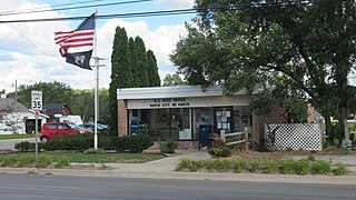
Rapid City is an unincorporated community and census-designated place (CDP) in Kalkaska County in the U.S. state of Michigan. At the 2020 census, the CDP had a population of 1,357. Rapid City is located within Clearwater Township, and is about 8 miles (13 km) northwest of Kalkaska.
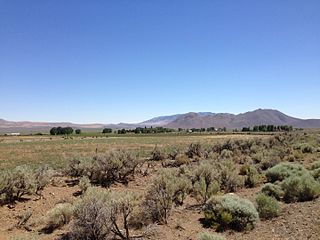
Denio is a census-designated place (CDP) in Humboldt County, Nevada, along the Oregon state line in the United States. The Denio post office was originally north of the state line in Harney County, Oregon, but the residents moved the building into Nevada in the mid-20th century. The population of the CDP, which is entirely in Nevada, was 47 at the 2010 census; additional development considered to be Denio extends into Oregon. The CDP includes a post office, a community center, a library, and the Diamond Inn Bar, the center of the town's social life. Recreational activities in the Denio area include bird watching, photography, off road vehicle use, fishing, recreational black opal mining, rockhounding, hunting, visiting the hot springs, and camping on the Sheldon National Wildlife Refuge.
Belva is an unincorporated community and census-designated place in west Nicholas County and north Fayette County, West Virginia, United States; while the CDP only includes the Nicholas County portion, the Fayette County portion is considered part of the community. The town is situated at the bottomland surrounding the convergence of Bells Creek with Twentymile Creek and, subsequently, Twenty Mile Creek with the Gauley River. Belva is also the location of the convergence of two state highways: West Virginia Route 16 and West Virginia Route 39.

Bayside is a census-designated place (CDP) in Accomack County, Virginia, United States. It was first listed as a CDP in 2010. Per the 2020 census, the population was 107.
Calvert Beach is a census-designated place and unincorporated community in Calvert County, Maryland, United States. Its population was 808 as of the 2010 census. Prior to 2010, the community was part of the Calvert Beach-Long Beach CDP.
Fowlerville is a hamlet and census-designated place (CDP) in the town of York in Livingston County, New York, United States. The population of the CDP was 227 at the 2010 census.
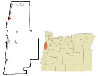
Fort Hill is an unincorporated community in Polk and Yamhill counties in Oregon, United States. It is located about a mile east of Spirit Mountain Casino on Oregon Route 22 near the South Yamhill River. For statistical purposes, the United States Census Bureau has defined Fort Hill as a census-designated place (CDP). The census definition of the area may not precisely correspond to local understanding of the area with the same name. The hill of the same name, located just east of Valley Junction, was the site of a blockhouse built by settlers in 1855–1856. The blockhouse became part of Fort Yamhill, and was later moved to Grand Ronde Agency and is now located in Dayton.

Acacia Villas is a census-designated place in Palm Beach County, Florida, United States. It is part of the Miami metropolitan area of South Florida. The population was 398 as of the 2020 census.
Lakewood Gardens was a former census-designated place in Palm Beach County, Florida, United States. Its population was 1,273 as of the 2010 census. In 2011, the area was annexed by the village of Palm Springs and is now one of its neighborhoods.
Foots Creek is an unincorporated community and census-designated place (CDP) in Jackson County, in the U.S. state of Oregon. It lies along Oregon Route 99 near the mouth of Foots Creek, where it empties into the Rogue River. Interstate 5 and Valley of the Rogue State Park are on the side of the river opposite Foots Creek.
Seventh Mountain is an unincorporated community and census-designated place (CDP) in Deschutes County, in the U.S. state of Oregon. The community lies along the west bank of the Deschutes River southwest of Bend.
Chiawuli Tak is both a census-designated place (CDP) as well as a populated place in Pima County, Arizona, United States. Chiawuli Tak means "the barrel cactus sits" in the O'odham language. It is also unofficially known as Geowic, Jeowic, or Tjeavolitak. The population was 78 at the 2010 census.
Groveland Station is a census-designated place (CDP) in Livingston County, New York, United States. The CDP consists of the hamlet of Groveland and nearby residential areas. The CDP population was 281 as of the 2010 census. New York State Route 63 passes through the community.

Dunstan is a census-designated place (CDP) in the town of Scarborough, Cumberland County, Maine, United States. Also known as West Scarborough, the community is in the southwest part of the town, along U.S. Route 1. Maine State Route 9 runs northward from Dunstan with US 1 towards Portland but leads southeastward out of the community as Pine Point Road, towards Old Orchard Beach. Interstate 95 forms the northwestern edge of the CDP, and the York County line is the southwestern border, with the city of Saco directly adjacent to Dunstan. The northeast edge of the CDP is the Dunstan River, an arm of the tidal Scarborough River.
Gandys Beach is a census-designated place (CDP) located in Cumberland County, in the U.S. state of New Jersey. It is in the southwestern part of the county, in the western part of Downe Township, on the shore of Delaware Bay. It is 5 miles (8 km) southwest of Newport and 16 miles (26 km) southwest of Millville.
Oregon Shores is a census-designated place (CDP) in Klamath County, Oregon, United States. It was first listed as a CDP prior to the 2020 census.


