
Table Mountain is a flat-topped mountain forming a prominent landmark overlooking the city of Cape Town in South Africa. It is a significant tourist attraction, with many visitors using the cableway or hiking to the top. Table Mountain National Park is the most visited national park in South Africa, attracting 4.2 million people every year for various activities. The mountain has 8,200 plant species, of which around 80% are fynbos, meaning fine bush. It forms part of the Table Mountain National Park, and part of the lands formerly ranged by Khoe-speaking clans, such as the !Uriǁʼaes. It is home to a large array of mostly endemic fauna and flora.
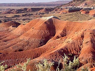
The Painted Desert is a United States desert of badlands in the Four Corners area, running from near the east end of Grand Canyon National Park and southeast into Petrified Forest National Park. It is most easily accessed from the north portion of Petrified Forest National Park. The Painted Desert is known for its brilliant and varied colors: these include the more common red rock, but also shades of lavender.

The Boston Mountains is a Level III ecoregion designated by the Environmental Protection Agency (EPA) in the U.S. states of Arkansas and Oklahoma. Part of the Ozarks, the Boston Mountains are a deeply dissected plateau. The ecoregion is steeper than the adjacent Springfield Plateau to the north, and bordered on the south by the Arkansas Valley. The Oklahoma portion of the range is locally referred to as the Cookson Hills. There are several theories of how the mountains were named, though apparently none are related to the Massachusetts city.

A mesa is an isolated, flat-topped elevation, ridge or hill, which is bounded from all sides by steep escarpments and stands distinctly above a surrounding plain. Mesas characteristically consist of flat-lying soft sedimentary rocks capped by a more resistant layer or layers of harder rock, e.g. shales overlain by sandstones. The resistant layer acts as a caprock that forms the flat summit of a mesa. The caprock can consist of either sedimentary rocks such as sandstone and limestone; dissected lava flows; or a deeply eroded duricrust. Unlike plateau, whose usage does not imply horizontal layers of bedrock, e.g. Tibetan Plateau, the term mesa applies exclusively to the landforms built of flat-lying strata. Instead, flat-topped plateaus are specifically known as tablelands.
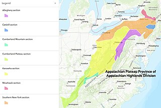
The Appalachian Plateau is a series of rugged dissected plateaus located on the western side of the Appalachian Mountains. The Appalachian Mountains are a range that run from Nova Scotia in Canada to Alabama in the United States.

The Chagrin River is located in Northeast Ohio. The river has two branches, the Aurora Branch and East Branch. Of three hypotheses as to the origin of the name, the most probable is that it is a corruption of the name of a Frenchman, Sieur de Seguin, who established a trading post on the river ca. 1742. The Chagrin River runs through suburban areas of Greater Cleveland in Cuyahoga, Geauga, and Portage counties, transects two Cleveland Metroparks reservations, and then meanders into nearby Lake County before emptying into Lake Erie.
California's 18th congressional district is a congressional district located in the U.S. state of California. The district is currently represented by Democrat Zoe Lofgren. Since the 2022 election, the district is landlocked and includes all of San Benito County and parts of Santa Clara and Monterey counties, including Salinas, Hollister, Watsonville, Gilroy, Soledad, and downtown and eastern San Jose.
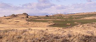
The Withrow Moraine and Jameson Lake Drumlin Field is a National Park Service–designated privately owned National Natural Landmark located in Douglas County, Washington state, United States. Withrow Moraine is the only Ice Age terminal moraine on the Waterville Plateau section of the Columbia Plateau. The drumlin field includes excellent examples of glacially-formed elongated hills.

Bald Eagle Valley is a low-lying area in Pennsylvania that drains into Bald Eagle Creek between the Allegheny Front and Bald Eagle Mountain, south of the West Branch Susquehanna River, in the Ridge-and-valley Appalachians. The valley is located southwest of West Branch Susquehanna Valley and includes Williamsport, Nittany Valley, and State College in the central portion of Centre County and southern portion of Clinton County.

Bald Eagle Mountain – once known locally as Muncy Mountain – is a stratigraphic ridge in the Ridge-and-Valley Appalachians of central Pennsylvania, United States, running east of the Allegheny Front and northwest of Mount Nittany. It lies along the southeast side of Bald Eagle Creek and south of the West Branch Susquehanna River, and is the westernmost ridge in its section of the Ridge-and-Valley Appalachians. The ridge line separates the West Branch Susquehanna Valley from the Nippenose and White Deer Hole valleys, and Bald Eagle Valley from Nittany Valley.

Tussey Mountain is a stratigraphic ridge in central Pennsylvania, United States, trending east of the Bald Eagle, Brush, Dunning and Evitts Mountain ridges. Its southern foot just crosses the Mason–Dixon line near Flintstone, Maryland, running north 130 km (80 mi) to the Seven Mountains of central Pennsylvania, near Tusseyville, making it one of the longest named ridges in this section of the Ridge-and-valley Appalachians.
Gildersleeve Mountain is a summit located in Kirtland, Ohio, United States.

The Silurian Tuscarora Formation — also known as Tuscarora Sandstone or Tuscarora Quartzite — is a mapped bedrock unit in Pennsylvania, Maryland, West Virginia, and Virginia, US.
State Route 36 (SR 36) is a 44.5-mile-long (71.6 km) east–west state highway in the northern part of the U.S. state of Alabama. The western terminus of the highway is at its intersection with SR 33 at Wren, an unincorporated community in Lawrence County. The eastern terminus of the highway is at its intersection with U.S. Route 231 (US 231) at Lacey’s Spring in Morgan County.

U.S. Route 231 (US 231) in Alabama runs north–south up through the eastern half of Alabama for 306.273 miles (492.899 km). US 231 enters the state from Florida south of Madrid and exits into Tennessee, running councurrently with US 431 north of Hazel Green. US 231 passes through the major cities of Dothan, Troy, Montgomery, and Huntsville.

The geology of Kansas encompasses the geologic history and the presently exposed rock and soil. Rock that crops out in the US state of Kansas was formed during the Phanerozoic eon, which consists of three geologic eras: the Paleozoic, Mesozoic and Cenozoic. Paleozoic rocks at the surface in Kansas are primarily from the Mississippian, Pennsylvanian, and Permian periods.

The Hamilton Group is a Devonian-age geological group which is located in the Appalachian region of the United States. It is present in New York, Pennsylvania, Maryland, Ohio, West Virginia, northwestern Virginia and Ontario, Canada, and is mainly composed of marine shale with some sandstone.

The Marcellus Formation or the Marcellus Shale is a Middle Devonian age unit of sedimentary rock found in eastern North America. Named for a distinctive outcrop near the village of Marcellus, New York, in the United States, it extends throughout much of the Appalachian Basin.

The Black Hills is an isolated mountain range rising from the Great Plains of North America in western South Dakota and extending into Wyoming, United States. Black Elk Peak, which rises to 7,244 feet (2,208 m), is the range's highest summit. The Black Hills encompass the Black Hills National Forest. The name of the hills in Lakota is Pahá Sápa. The Black Hills are considered a holy site. The hills are so called because of their dark appearance from a distance, as they are covered in evergreen trees.

Spruce Mountain, located in eastern West Virginia, is the highest ridge of the Allegheny Mountains. The whale-backed ridge extends for only 16 miles (26 km) from northeast to southwest, but several of its peaks exceed 4,500 feet (1,400 m) in elevation. The summit, Spruce Knob, is the highest Allegheny Mountain point both in the state and the entire range, which spans four states.

