
Gateway National Recreation Area is a 26,607-acre (10,767 ha) U.S. National Recreation Area in New York City and Monmouth County, New Jersey. It provides recreational opportunities that are not commonly found in a dense urban environment, including ocean swimming, bird watching, boating, hiking and camping. More than 8.7 million people visited Gateway National Recreation Area in 2022, making it the fourth-most visited unit of the National Park Service.

The protected areas of the United States are managed by an array of different federal, state, tribal and local level authorities and receive widely varying levels of protection. Some areas are managed as wilderness, while others are operated with acceptable commercial exploitation. As of 2022, the 42,826 protected areas covered 1,235,486 km2 (477,024 sq mi), or 13 percent of the land area of the United States. This is also one-tenth of the protected land area of the world. The U.S. also had a total of 871 National Marine Protected Areas, covering an additional 1,240,000 sq mi (3,200,000 km2), or 26 percent of the total marine area of the United States.
Monte Sano Mountain is a mountain located in Huntsville, Alabama. The name Monte Sano is Spanish for "Mountain of health". The mountain was given its name by Dr. Thomas Fern, who along with his two brothers, founded a small colony on the mountain during an epidemic of yellow fever, malaria, and cholera. The location on the mountain was chosen because of its cool air and medicinal springs.
Monte Sano State Park is a public recreation area and mountaintop retreat encompassing 2,140 acres (870 ha) on the eastern portion of the top and slopes of Monte Sano Mountain on the east side of Huntsville, Alabama. The state park has 1930s-era, Civilian Conservation Corps–built rustic cottages, hiking trails and picnic areas with scenic overlooks, and modern campsites. It is managed by the Alabama Department of Conservation and Natural Resources.

The New York – New Jersey Trail Conference (NYNJTC) is a volunteer-based federation of approximately 10,000 individual members and about 100 member organizations. The conference coordinates the maintenance of 2,000 miles of foot trails around the New York metropolitan area, from the Delaware Water Gap, north to beyond the Catskill Mountains, including the Appalachian Trail through New York and New Jersey. It also works to protect open space and publishes books and trail maps. The organization's headquarters are at 600 Ramapo Valley Road, Mahwah, New Jersey.
Taconic State Park is located in Columbia and Dutchess County, New York abutting Massachusetts and Connecticut within the Taconic Mountains. The state park is located off New York State Route 344 south of Interstate 90 and 110 miles (180 km) north of New York City. It features camping, hiking, bicycling, hunting, cross county skiing and other recreational opportunities.
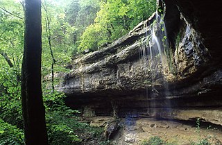
Bad Branch Falls State Nature Preserve is a forested gorge covering 2,639 acres near Whitesburg, KY in Letcher County, Kentucky. The deep and narrow gorge, adjacent to the Jefferson National Forest is carved into the face of Pine Mountain. Sandstone boulders and cliffs along with riglines and knobs provide views into the Appalachia area. The terrain is landscaped with streams, rivers, and a 60-foot waterfall. With a variety of habitat types, this nature preserve is home to many unique and unknown species of flora and fauna.
Open Space Institute (OSI) is a conservation organization that protects land for clean drinking water, public recreation, healthy communities, wildlife habitat, and climate protection. Established in 1974, OSI achieves its goals through land acquisition, fiscal sponsorship, regional loan and grant programs, park and trail improvements, and public policy and advocacy. OSI is active across the country, including the states of New York, Vermont, New Hampshire, Maine, Georgia, South Carolina, Virginia, Tennessee, New Jersey, Massachusetts, Pennsylvania, Alabama, West Virginia, North Carolina, and Florida.

Cross Ranch State Park is a public recreation area covering 569 acres (230 ha) on the west bank of the Missouri River nine miles (14 km) south of Washburn in Oliver County, North Dakota. The Nature Conservancy's Cross Ranch Nature Preserve, a 6,000-acre (2,400 ha) preserve which features a roaming herd of more than 200 adult bison, lies adjacent to the state park.
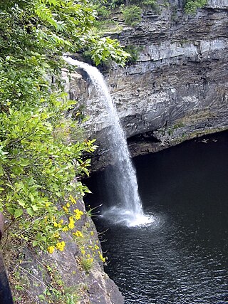
DeSoto State Park is a public recreation area located on Lookout Mountain 8 miles (13 km) northeast of Fort Payne, Alabama. The state park covers 3,502 acres (1,417 ha) of forest, rivers, waterfalls, and mountain terrain. It borders the Little River, which flows into the nearby Little River Canyon National Preserve. The 104-foot-tall (32 m) DeSoto Falls, the state's highest waterfall, is found in a separate part of the park 6 miles (9.7 km) north of the main park.
Conserving Carolina is a non-profit conservation organization working to preserve water and land resources in Western North Carolina. Conserving Carolina was created in July 2017, from a merger of two previously separate organizations, Carolina Mountain Land Conservancy and Pacolet Area Conservancy. The combined organization maintains a primary office in Hendersonville, North Carolina, and a regional office in Columbus, North Carolina.

Clematis morefieldii is a rare species of flowering plant in the buttercup family known by the common names Morefield's leather flower and Huntsville vasevine.

An extensive collection of parks and greenways exists in Huntsville, Alabama for the public's recreational use.

Hook Mountain State Park is a 676-acre (2.74 km2) undeveloped state park located in Rockland County, New York. The park includes a portion of the Hudson River Palisades on the western shore of the Hudson River, and is part of the Palisades Interstate Park system. Hook Mountain State Park is functionally part of a continuous complex of parks that also includes Rockland Lake State Park, Nyack Beach State Park, and Haverstraw Beach State Park.
Monte Sano Nature Preserve is, at 1,107 acres (448 ha), one of the largest urban nature preserves in the US and is located on Monte Sano Mountain in Huntsville, Alabama. The Land Trust of North Alabama manages the nature preserve and Land Trust volunteers have created 23+ miles of public trails. Residents and visitors alike enjoy the multi-use trails for hiking, biking, running, bird watching, environmental education, and general recreation. The trail system was honored in 2011 by the Department of the Interior as National Recreation Trails making them the first NRT trails in Madison County.

Blevins Gap Nature Preserve is a nature preserve in southern Huntsville, Alabama. It measures 994 acres (402 ha) in total and contains over 12 miles of trails within its borders. Cecil Ashburn Drive splits the preserve into two parts. The northern section measures 267 acres (108 ha) with 4.5 miles of trails, a rocky incline, and waterfalls. The southern portion measures the remaining 727 acres (294 ha) and contains 8 miles of woodland trails.
Wind Wolves Preserve is a nature preserve owned and managed by The Wildlands Conservancy, a nonprofit land conservancy. Covering 93,000 acres (380 km2) in Kern County, California, the preserve is located 35 miles (56 km) southwest of Bakersfield and features the San Emigdio Mountains and Pleito Hills. It is the largest nonprofit nature reserve on the West Coast and is part of the list of preserves.
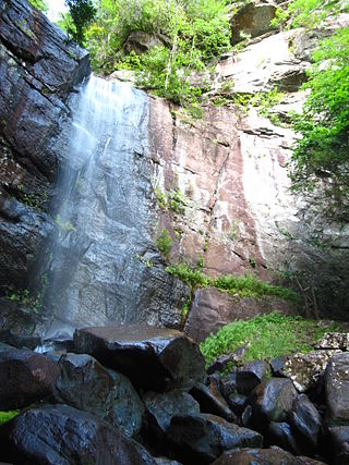
Florence Nature Preserve is a publicly-accessible privately owned park in Gerton, Henderson County, North Carolina in the United States. The 600-acre (2.4 km2) park is located 18 miles (29 km) southeast of Asheville, North Carolina, and is owned and managed by Conserving Carolina, a land trust.
Rainbow Mountain is a mountain in Madison county, Alabama. The mountain's name is derived from the name of Elisha Rainboll, who settled on the mountain around 1810.

