Brooklyn (village), Wisconsin

Last updated

Brooklyn (village), Wisconsin
Brooklynwi.jpg
Dane County Wisconsin Incorporated and Unincorporated areas Brooklyn Highlighted.svg
Location of Brooklyn in Dane County, Wisconsin.
USA Wisconsin location map.svg
Red pog.svg
Brooklyn
Usa edcp location map.svg
Red pog.svg
Brooklyn
Coordinates: 42°51′13″N89°22′11″W / 42.853600°N 89.369689°W / 42.853600; -89.369689
CountryUnited States
State Wisconsin
County
Area
[1]
  Total1.12 sq mi (2.90 km2)
  Land1.12 sq mi (2.89 km2)
  Water0.01 sq mi (0.01 km2)
Population
 (2020) [2]
  Total1,524
  Density1,365.6/sq mi (527.3/km2)
FIPS code 55-10075
GNIS feature ID1582869
Website brooklynwi.gov

Brooklyn is a village in Dane and Green counties in Wisconsin, United States. The population was 1,524 at the 2020 census, [2] with 1,026 residents in Dane County and 498 in Green County.

Contents

The Dane County portion of Brooklyn is part of the Madison Metropolitan Statistical Area, while the Green County portion is part of the Monroe Micropolitan Statistical Area.

History

The village was incorporated in 1905. It was named after Brooklyn, New York. [3]

Geography

According to the United States Census Bureau, the village has a total area of 1.12 square miles (2.90 km2), all of it land. [4]

The village straddles the boundary between the Sugar-Pecatonica river basin (Allen Creek and Middle Sugar River watershed) draining to the west, and Lower Rock river basin (Badfish Creek watershed) draining to the east. [5]

Demographics

Historical population
CensusPop.Note
1910 362
1920 40712.4%
1930 406−0.2%
1940 44910.6%
1950 4796.7%
1960 59023.2%
1970 565−4.2%
1980 62711.0%
1990 78925.8%
2000 91616.1%
2010 1,40152.9%
2020 1,5248.8%
U.S. Decennial Census [6]

2020 census

As of the census of 2020, [2] the population was 1,524. The population density was 1,365.6 inhabitants per square mile (527.3/km2). There were 558 housing units at an average density of 500.0 units per square mile (193.1 units/km2). The racial makeup of the village was 88.7% White, 2.2% Black or African American, 0.3% Asian, 0.2% Native American, 0.1% Pacific Islander, 1.6% from other races, and 7.0% from two or more races. Ethnically, the population was 5.2% Hispanic or Latino of any race.

Young population

Brooklyn has gained and maintained a population of young adults at an above-average rate. [7] According to a 2017 case study by the University of Wisconsin-Madison, young adults have cited Brooklyn's affordable housing, high-quality local schools, proximity to both Madison and Janesville, and "small-town feel" with a "sense of safety and community" as reasons why they had chosen to live in Brooklyn. [8]

2010 census

As of the census [9] of 2010, there were 1,401 people, 508 households, and 391 families living in the village. The population density was 1,285.3 inhabitants per square mile (496.3/km2). There were 527 housing units at an average density of 483.5 units per square mile (186.7 units/km2). The racial makeup of the village was 95.1% White, 2.0% African American, 0.1% Native American, 0.6% Asian, 1.1% from other races, and 1.1% from two or more races. Hispanic or Latino of any race were 5.9% of the population.

There were 508 households, of which 46.1% had children under the age of 18 living with them, 60.4% were married couples living together, 9.6% had a female householder with no husband present, 6.9% had a male householder with no wife present, and 23.0% were non-families. 15.9% of all households were made up of individuals, and 5.3% had someone living alone who was 65 years of age or older. The average household size was 2.76 and the average family size was 3.11.

The median age in the village was 32.8 years. 30% of residents were under the age of 18; 6.3% were between the ages of 18 and 24; 34.9% were from 25 to 44; 23.4% were from 45 to 64; and 5.6% were 65 years of age or older. The gender makeup of the village was 50.4% male and 49.6% female.

2000 census

As of the census [10] of 2000, there were 916 people, 343 households, and 255 families living in the village. The population density was 837.4 people per square mile (323.3 people/km2). There were 351 housing units at an average density of 320.9 units per square mile (123.9 units/km2). The racial makeup of the village was 98.25% White, 0.22% African American, 0.44% Asian, 0.33% from other races, and 0.76% from two or more races. Hispanic or Latino of any race were 1.42% of the population.

There were 343 households, out of which 43.1% had children under the age of 18 living with them, 60.3% were married couples living together, 9.0% had a female householder with no husband present, and 25.4% were non-families. 18.7% of all households were made up of individuals, and 8.7% had someone living alone who was 65 years of age or older. The average household size was 2.67 and the average family size was 3.08.

In the village, the population was spread out, with 30.1% under the age of 18, 5.9% from 18 to 24, 39.0% from 25 to 44, 16.6% from 45 to 64, and 8.4% who were 65 years of age or older. The median age was 33 years. For every 100 females, there were 104.0 males. For every 100 females age 18 and over, there were 104.5 males.

The median income for a household in the village was $48,056, and the median income for a family was $51,607. Males had a median income of $34,934 versus $25,893 for females. The per capita income for the village was $19,480. About 1.1% of families and 2.9% of the population were below the poverty line, including 1.5% of those under age 18 and 18.2% of those age 65 or over.

Parks and recreation

There are three parks in the village—Smithfield Park on the eastern side, Legion Park on the southern side, and Water Tower Park on the northern side. Smithfield Park contains a basketball court, a picnic pavilion, public lavatories with drinking fountains, and a playground.

Government

The village is governed by a seven-member board of trustees, one of whom serves as the village president. Each trustee is elected in a village-wide race.

Education

Brooklyn Elementary School, a public school, is part of the Oregon School District.

Infrastructure

Transportation

Roads

Wisconsin state highways 92 and 104 intersect in the village. Dane county highway MM terminates at that intersection.

Railways

The Beloit and Madison Railroad was built through the village in the 1800s before being acquired by the Chicago and North Western railway. From 1880 to the early 1950s the line was double tracked. The line was abandoned in 1996 and sold to the cities of Oregon and Fitchburg. It still exists but is out of service.[ citation needed ]

See also

Related Research Articles

<span class="mw-page-title-main">Dane County, Wisconsin</span> County in Wisconsin, United States

Dane County is a county in the U.S. state of Wisconsin. As of the 2020 census, the population was 561,504, making it the second-most populous county in Wisconsin after Milwaukee County. The county seat is Madison, which is also the state capital. Dane County is the central county of the Madison, Wisconsin, Metropolitan Statistical Area, as well as the Madison-Janesville-Beloit Combined Statistical Area.

<span class="mw-page-title-main">Berry, Wisconsin</span> Town in Wisconsin, United States

Berry is a town in Dane County, Wisconsin, United States. The population was 1,168 at the 2020 census. The unincorporated community of Marxville is in the Town of Berry.

<span class="mw-page-title-main">Burke, Wisconsin</span> Town in Wisconsin, United States

Burke is a town in Dane County, Wisconsin, United States. The population was 3,265 at the 2020 census. The unincorporated communities of Burke and Seminary Springs are in the town.

<span class="mw-page-title-main">Christiana, Dane County, Wisconsin</span> Town in Wisconsin, United States

The Town of Christiana is located in Dane County, Wisconsin, United States. The population was 1,235 at the 2020 census. It is named after Oslo, Norway and has one of the highest percentages of Norwegian ancestry in the United States. The unincorporated community of Utica and the village of Rockdale are located within the town. The village of Cambridge is located partly within the Town.

<span class="mw-page-title-main">Maple Bluff, Wisconsin</span> Village in Wisconsin, United States

Maple Bluff is a village in Dane County, Wisconsin, United States. The population was 1,313 at the 2010 census. A suburb of Madison, it is part of the Madison Metropolitan Statistical Area.

<span class="mw-page-title-main">Marshall, Dane County, Wisconsin</span> Village in Wisconsin, United States

Marshall is a village in Dane County, Wisconsin, United States, along the Maunesha River. The population was 3,787 at the 2020 United States Census. It is part of the Madison Metropolitan Statistical Area.

<span class="mw-page-title-main">Rockdale, Wisconsin</span> Village in Wisconsin, United States

Rockdale is a village in Dane County, Wisconsin, United States. The population was 207 at the 2020 census, making it the smallest incorporated municipality in Dane County. The village is split in half by the Koshkonong Creek. It is part of the Madison Metropolitan Statistical Area.

<span class="mw-page-title-main">Rutland, Wisconsin</span> Town in Wisconsin, United States

Rutland is a town in Dane County, Wisconsin, United States. The population was 1,977 by the US Census Bureau 2020 census The population was 1,887 at the 2000 census. However, for 2021, the Wisconsin Dept. of Administration declared the population of the Town to be 2,032. The unincorporated communities of Rutland and Stone are located in the town.

<span class="mw-page-title-main">Shorewood Hills, Wisconsin</span> Village in Wisconsin, United States

Shorewood Hills is a village in Dane County, Wisconsin, United States. It was established in 1927. The population was 2,169 at the 2020 census. Entirely surrounded by the city of Madison and Lake Mendota, it is part of the Madison Metropolitan Statistical Area.

<span class="mw-page-title-main">Springfield, Dane County, Wisconsin</span> Town in Wisconsin, United States

Springfield is a town in Dane County, Wisconsin, United States. The population was 2,929 at the time of the 2020 census. The unincorporated communities of Ashton, Ashton Corners, Kingsley Corners, Martinsville, and Springfield Corners are located in Springfield.

<span class="mw-page-title-main">Westport, Wisconsin</span> Town in Wisconsin, United States

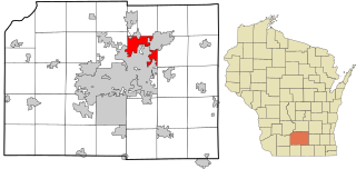
The Town of Westport is located in Dane County, Wisconsin, United States and a suburb of Madison. The population was 4,183 at the 2020 census. The town was named after Westport, County Mayo in Ireland because many of the early settlers were from there. The village of Waunakee was carved out of the town in 1893, leaving the remainder of the town on both sides. Other portions have been annexed by the cities of Madison and Middleton. A portion of the Town of Madison on the northern shore of Lake Mendota was transferred to the Town of Westport.

<span class="mw-page-title-main">Belleville, Wisconsin</span> Village in Wisconsin, United States

Belleville is a village in Dane and Green counties in the U.S. state of Wisconsin. The population was 2,491 at the 2020 census. Of this, 1,909 were in Dane County, and 582 were in Green County.

<span class="mw-page-title-main">Cambridge, Wisconsin</span> Village in Wisconsin, United States

Cambridge is a village in Dane (mostly) and Jefferson counties in the U.S. state of Wisconsin. The population was 1,638 at the 2020 census. Of this, 1,539 were in Dane County, and 99 were in Jefferson County.

<span class="mw-page-title-main">Black Earth, Wisconsin</span> Village in Wisconsin, United States

Black Earth is a village in Dane County, Wisconsin, United States. The population was 1,338 at the 2010 census. The village is located within the Town of Black Earth. It is part of the Madison Metropolitan Statistical Area.

<span class="mw-page-title-main">Blue Mounds, Wisconsin</span> Village in U.S. state of Wisconsin

Blue Mounds is a village in Dane County, Wisconsin, United States. As of the 2020 census, the village had a population of 950. The village is adjacent to the Town of Blue Mounds, and is part of the Madison Metropolitan Statistical Area.

<span class="mw-page-title-main">Cross Plains, Wisconsin</span> Village in Wisconsin, United States

Cross Plains is a village in Dane County, Wisconsin, United States. The population was 4,104 at the 2020 census. The village is located partially within the Town of Cross Plains. It is part of the Madison Metropolitan Statistical Area.

<span class="mw-page-title-main">Dane, Wisconsin</span> Village in Wisconsin, United States

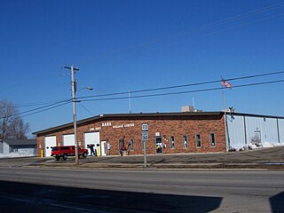
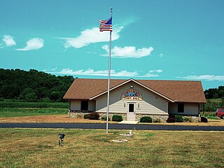
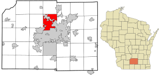
Dane is a village in Dane County, Wisconsin, United States. The population was 1,117 at the 2020 census. Located in the Town of Dane, the village is part of the Madison Metropolitan Statistical Area.

<span class="mw-page-title-main">Deerfield, Wisconsin</span> City in Wisconsin, United States

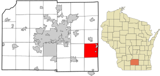
Deerfield is a city in Dane County, Wisconsin. The population was 2,319 at the time of the 2010 census. The city is located within the Town of Deerfield. It is part of the Madison Metropolitan Statistical Area. Towns and villages near Deerfield include Marshall, Medina, London, Cambridge, and Cottage Grove, Wisconsin.

<span class="mw-page-title-main">Madison (town), Wisconsin</span> Town in Wisconsin, United States

The Town of Madison was located in Dane County, Wisconsin, United States. The town ceased to exist on October 31, 2022. Its final population was 6,236 at the 2020 United States census. The majority of the town's territory was situated along the Madison Beltline Highway, comprising several neighborhoods situated between the south side of the city of Madison, and the north side of the city of Fitchburg. The town also had territory on the north side of Madison near the border with Maple Bluff, as well as a few lots on the west side of Madison near Whitney Way. The Dane County Expo Center and Alliant Energy Center was situated within the Town of Madison. Despite its status as an unincorporated community, the Town of Madison provided a variety of services to its residents which typically would only be found in incorporated cities and villages, including trash and recycling services, police, fire and emergency medical services; sewer and water utilities; and three public parks.

<span class="mw-page-title-main">Oregon, Wisconsin</span> Village in Wisconsin, United States

Oregon is a village in Dane County, Wisconsin. As of the census of 2020, the population was 11,179. Oregon is part of the Madison Metropolitan Statistical Area. The village is located mostly within the Town of Oregon.

References

  1. "2019 U.S. Gazetteer Files". United States Census Bureau. Retrieved August 7, 2020.
  2. 1 2 3 "2020 Decennial Census: Brooklyn village, Wisconsin". data.census.gov. U.S. Census Bureau. Retrieved July 27, 2022.
  3. Chicago and North Western Railway Company (1908). A History of the Origin of the Place Names Connected with the Chicago & North Western and Chicago, St. Paul, Minneapolis & Omaha Railways. p. 47.
  4. "2020 Gazetteer Files". census.gov. U.S. Census Bureau. Retrieved July 27, 2022.
  5. "Watershed Map - Office of Lakes and Watersheds - Dane County, Wisconsin". danewaters.com. May 7, 2008. Archived from the original on May 7, 2008. Retrieved February 18, 2022.
  6. "Census of Population and Housing". Census.gov. Retrieved June 4, 2015.
  7. Pat Schneider, The Cap Times, “UW-Madison study suggests asking young people how to attract millennials,” Jan 13, 2018.
  8. Sheamus Johnson, “Gaining and maintaining young people in Wisconsin communities: Case study: Brooklyn.”
  9. "U.S. Census website". United States Census Bureau . Retrieved November 18, 2012.
  10. "U.S. Census website". United States Census Bureau . Retrieved January 31, 2008.