Madison (town), Wisconsin

Last updated

Town of Madison, Wisconsin
Town of Madison Municipal Building.jpg
Town of Madison Municipal Building
Dane County Wisconsin incorporated and unincorporated areas Madison (town) highlighted.svg
Location in Dane County and the state of Wisconsin.
USA Wisconsin location map.svg
Red pog.svg
Madison
Usa edcp location map.svg
Red pog.svg
Madison
Coordinates: 43°2′32″N89°24′5″W / 43.04222°N 89.40139°W / 43.04222; -89.40139
Country Flag of the United States.svg  United States
State Flag of Wisconsin.svg  Wisconsin
County Dane
Area
  Total1.5 sq mi (4 km2)
  Land1.48 sq mi (3.8 km2)
  Water0.01 sq mi (0.03 km2)
Elevation
[1]
846 ft (258 m)
Population
 (2020)
  Total6,236
  Density4,324.1/sq mi (1,669.5/km2)
Time zone UTC-6 (Central (CST))
  Summer (DST) UTC-5 (CDT)
Area code 608
FIPS code 55-48025 [2]
GNIS feature ID1583626 [1]

The Town of Madison was located in Dane County, Wisconsin, United States. The town ceased to exist on October 31, 2022. Its final population was 6,236 at the 2020 United States census. The majority of the town's territory was situated along the Madison Beltline Highway, comprising several neighborhoods situated between the south side of the city of Madison, and the north side of the city of Fitchburg. The town also had territory on the north side of Madison near the border with Maple Bluff, as well as a few lots on the west side of Madison near Whitney Way. The Dane County Expo Center and Alliant Energy Center was situated within the Town of Madison. Despite its status as an unincorporated community, the Town of Madison provided a variety of services to its residents which typically would only be found in incorporated cities and villages, including trash and recycling services, police, fire and emergency medical services; sewer and water utilities; and three public parks.

Contents

History

The original Town of Madison encompassed approximately 36 square miles (93 km2), and was organized on February 2, 1846. [3] [4] In 1856 the Wisconsin Legislature chartered the city of Madison, leaving the remainder as the town. [5] Most of this land was gradually incorporated into various municipalities, especially the City of Madison, leaving the town as a collection of discontinuous areas subject to annexation. For example, the Burr Oaks neighborhood had an area in the Town of Madison and an area in the City of Madison, connected by Cypress Way. That was the same case with part of the Capitol View Heights neighborhood, connected by Sundstrom and Nygard Streets.

In the wake of continued controversy and an effort in the state legislature to simply abolish the town[ citation needed ], an agreement was reached in 2003 to provide for the incorporation of the remaining portions of the town (by then down to less than 3.9 square miles (10 km2), including bodies of water) into the city of Madison and the city of Fitchburg on October 31, 2022. [6] The dissolution took place on schedule. [7]

Geography

According to the United States Census Bureau, the town had[ when? ] a total area of 1.5 square miles (3.9 km2), of which 1.4 square miles (3.6 km2) was land and 0.01 square miles (0.026 km2) (0.67%) was water.

Demographics

Historical population
CensusPop.Note
1870 857
1880 735−14.2%
1890 91925.0%
1900 1,56770.5%
1910 1,7058.8%
1920 2,32736.5%
1930 3,35544.2%
1940 4,63838.2%
1950 4,195−9.6%
1960 4,92517.4%
1970 4,568−7.2%
1980 6,16234.9%
1990 6,4424.5%
2000 7,0058.7%
2010 6,279−10.4%
2020 6,2770.0%
U.S. Decennial Census [8]

As of the census [9] of 2010, there were 6,279 people, 2,852 households, and 1,212 families residing in the town. The population density was 4,234.1 people per square mile (1,669.5/km2). There were 3,069 housing units at an average density of 2,069.5 per square mile (799/km2). The racial makeup of the town was 54.6% White, 20.1% Black or African American, 0.9% Native American, 5.9% Asian, 0.0% Pacific Islander, 13.7% from other races, and 4.8% from two or more races. 28.0% of the population were Hispanic or Latino of any race.

There were 2,852 households, out of which 25.4% had children under the age of 18 living with them, 22.6% were married couples living together, 13.6% had a female householder with no husband present, and 57.5% were non-families. 41.8% of all households were made up of individuals, and 3.7% had someone living alone who was 65 years of age or older. The average household size was 2.20 and the average family size was 3.19.

In the town, the population was spread out, with 23.2% under the age of 18, 16.8% from 18 to 25, 36.8% from 25 to 44, 18.8% from 45 to 64, and 4.4% who were 65 years of age or older. The median age was 28.6 years. For every 100 females, there were 110.9 males. For every 100 females age 18 and over, there were 109.8 males.

The median income for a household in the town was $29,766, and the median income for a family was $37,344. Males had a median income of $31,450 versus $25,795 for females. The per capita income for the town was $19,566. About 22.0% of families and 25.9% of the population were below the poverty line, including 51.2% of those under age 18 and 11.1% of those age 65 or over. [10]

Related Research Articles

<span class="mw-page-title-main">Dane County, Wisconsin</span> County in Wisconsin, United States

Dane County is a county in the U.S. state of Wisconsin. As of the 2020 census, the population was 561,504, making it the second-most populous county in Wisconsin after Milwaukee County. The county seat is Madison, which is also the state capital.

<span class="mw-page-title-main">Berry, Wisconsin</span> Town in Wisconsin, United States

Berry is a town in Dane County, Wisconsin, United States. The population was 1,168 at the 2020 census. The unincorporated community of Marxville is in the Town of Berry.

<span class="mw-page-title-main">Blooming Grove, Wisconsin</span> Town in Wisconsin, United States

Blooming Grove is a town in Dane County, Wisconsin, United States. The population was 1,768 at the 2000 census. The unincorporated community of Hope is located partially within Blooming Grove. Although once much larger, currently the town of Blooming Grove consists of a few scattered neighborhoods and individual properties broken into discontinuous sections by the cities of Madison and Monona. Blooming Grove is set to be dissolved and annexed into the city of Madison by 2027.

<span class="mw-page-title-main">Bristol, Dane County, Wisconsin</span> Town in Wisconsin, United States

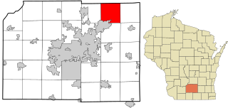
Bristol is a town in Dane County, Wisconsin, United States, located just north of the city of Sun Prairie and 15 miles northeast of Madison. The population was 4,447 at the 2020 census. The unincorporated communities of Bakers Corners, East Bristol, and North Bristol are located in the town.

<span class="mw-page-title-main">Burke, Wisconsin</span> Town in Wisconsin, United States

Burke is a town in Dane County, Wisconsin, United States. The population was 3,265 at the 2020 census. The unincorporated communities of Burke and Seminary Springs are in the town.

<span class="mw-page-title-main">Christiana, Dane County, Wisconsin</span> Town in Wisconsin, United States

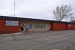
The Town of Christiana is located in Dane County, Wisconsin, United States. The population was 1,235 at the 2020 census. It is named after Oslo, Norway and has one of the highest percentages of Norwegian ancestry in the United States. The unincorporated community of Utica and the village of Rockdale are located within the town. The village of Cambridge is located partly within the Town.

<span class="mw-page-title-main">Dunkirk, Wisconsin</span> Town in Wisconsin, United States

The Town of Dunkirk is located in Dane County, Wisconsin, United States. The population was 2,053 at the 2000 census. The unincorporated community of Hanerville, which was named for James Haner, who had moved from Easton, New York in 1844, is located in the town.

<span class="mw-page-title-main">Fitchburg, Wisconsin</span> City in Wisconsin, United States

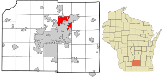
Fitchburg is a city in Dane County, Wisconsin, United States. The population was 29,609 at the 2020 census. Fitchburg is a suburb of Madison and is part of the Madison Metropolitan Statistical Area. Fitchburg consists of a mix of suburban neighborhoods closer to the border with the city of Madison, commercial and industrial properties, and more rural properties in the southern portion of the city.

<span class="mw-page-title-main">Pleasant Springs, Wisconsin</span> Town in Wisconsin, United States

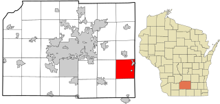
The Town of Pleasant Springs is located in Dane County, Wisconsin, United States. The population was 3,053 at the 2000 census. The unincorporated community of Kegonsa is located in the town. The unincorporated community of Hoffman Corners is also located partially in the town.

<span class="mw-page-title-main">Rutland, Wisconsin</span> Town in Wisconsin, United States

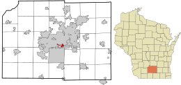
Rutland is a town in Dane County, Wisconsin, United States. The population was 1,977 by the US Census Bureau 2020 census The population was 1,887 at the 2000 census. However, for 2021, the Wisconsin Dept. of Administration declared the population of the Town to be 2,032. The unincorporated communities of Rutland and Stone are located in the town.

<span class="mw-page-title-main">Shorewood Hills, Wisconsin</span> Village in Wisconsin, United States

Shorewood Hills is a village in Dane County, Wisconsin, United States. It was established in 1927. The population was 2,169 at the 2020 census. Entirely surrounded by the city of Madison and Lake Mendota, it is part of the Madison Metropolitan Statistical Area.

<span class="mw-page-title-main">Springfield, Dane County, Wisconsin</span> Town in Wisconsin, United States

Springfield is a town in Dane County, Wisconsin, United States. The population was 2,929 at the time of the 2020 census. The unincorporated communities of Ashton, Ashton Corners, Kingsley Corners, Martinsville, and Springfield Corners are located in Springfield.

<span class="mw-page-title-main">Vienna, Wisconsin</span> Town in Wisconsin, United States

Vienna is a town in Dane County, Wisconsin, United States. The population was 1,666 at the 2020 census. The unincorporated community of Norway Grove is located in the town.

<span class="mw-page-title-main">Westport, Wisconsin</span> Town in Wisconsin, United States

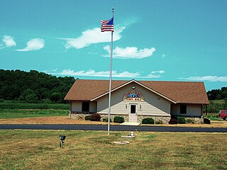
The Town of Westport is located in Dane County, Wisconsin, United States and a suburb of Madison. The population was 4,183 at the 2020 census. The town was named after Westport, County Mayo in Ireland because many of the early settlers were from there. The village of Waunakee was carved out of the town in 1893, leaving the remainder of the town on both sides. Other portions have been annexed by the cities of Madison and Middleton. A portion of the Town of Madison on the northern shore of Lake Mendota was transferred to the Town of Westport.

<span class="mw-page-title-main">Koshkonong, Wisconsin</span> Town in Wisconsin, United States

Koshkonong is a town in Jefferson County, Wisconsin, United States. The population was 3,763 at the 2020 census. The town entirely surrounds the city of Fort Atkinson. The unincorporated communities of Koshkonong Mounds and Vinnie Ha Ha are located in the town. The unincorporated communities of Blackhawk Island and Koshkonong, as well as The Census-designated place of Lake Koshkonong are also located partially in the town.

<span class="mw-page-title-main">Dane, Wisconsin</span> Village in Wisconsin, United States

Dane is a village in Dane County, Wisconsin, United States. The population was 1,117 at the 2020 census. Located in the Town of Dane, the village is part of the Madison Metropolitan Statistical Area.

<span class="mw-page-title-main">Deerfield, Wisconsin</span> City in Wisconsin, United States

Deerfield is a city in Dane County, Wisconsin. The population was 2,319 at the time of the 2010 census. The city is located within the Town of Deerfield. It is part of the Madison Metropolitan Statistical Area. Towns and villages near Deerfield include Marshall, Medina, London, Cambridge, and Cottage Grove, Wisconsin.

<span class="mw-page-title-main">Middleton (town), Wisconsin</span> Town in Wisconsin, United States

The Town of Middleton is located in Dane County, Wisconsin, United States. The Town of Middleton borders the cities of Middleton and Madison on the west. The population was 6,792 at the 2020 census. The unincorporated community of West Middleton are located in the town.

<span class="mw-page-title-main">Verona, Wisconsin</span> City in Wisconsin, United States

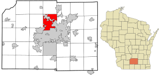
Verona is a city in Dane County, Wisconsin, United States. The population was 14,030 at the 2020 census. The city is located ten miles southwest of downtown Madison within the Town of Verona. It is part of the Madison metropolitan area.

<span class="mw-page-title-main">Brooklyn (village), Wisconsin</span> Place in Wisconsin, United States

Brooklyn is a village in Dane and Green counties in Wisconsin, United States. The population was 1,524 at the 2020 census, with 1,026 residents in Dane County and 498 in Green County.

References

  1. 1 2 "US Board on Geographic Names". United States Geological Survey. October 25, 2007. Retrieved January 31, 2008.
  2. "U.S. Census website". United States Census Bureau . Retrieved January 31, 2008.
  3. Madison, Election precinct of, Dane Co
  4. Madison, Town of, Dane Co
  5. Tenney, H.A. Madison, Dane County and Surrounding Towns; being a history and guide to places of scenic beauty and historical note found in the towns of Dane County and surroundings, including the organization of the towns, and early intercourse of the settlers with the Indians, their camps, trails, mounds, etc. with a complete list of county supervisors and officers, and legislative members, Madison Village and City Council. Madison: 1877; pp. 543-558.
  6. "2003 City of Madison, City of Fitchburg and Town of Madison Cooperative Plan" (PDF). Archived from the original (PDF) on December 5, 2014. Retrieved November 29, 2014.
  7. Mosiman, Dean (October 31, 2022). "Town of Madison dissolves, and some residents must change address, polling place". Wisconsin State Journal. Madison Media Partners Inc. Retrieved December 5, 2022.
  8. United States Census Bureau. "Census of Population and Housing". Archived from the original on October 3, 2014. Retrieved October 26, 2022.
  9. "U.S. Census website" United States Census Bureau. Retrieved June 20, 2012.
  10. "U.S. Census website" United States Census Bureau, 2006-2010 American Community Survey. Retrieved June 20, 2012.