Herringfleet is a place and former civil parish, now in the parish of Somerleyton, Ashby and Herringfleet, in the East Suffolk district, in the north of the English county of Suffolk. It is located 5.5 miles (8.9 km) north-west of Lowestoft. The parish was combined with Somerleyton and Ashby to create the parish of "Somerleyton, Ashby and Herringfleet" on 1 April 1987.

Baldock is a historic market town in the North Hertfordshire district of Hertfordshire, England. The River Ivel rises from springs in the town. It lies 33 miles (53 km) north of London and 14 miles (23 km) north northwest of the county town of Hertford. Nearby towns include Royston to the northeast, Letchworth and Hitchin to the southwest and Stevenage to the south.

Chadlington is a village and civil parish in the Evenlode Valley about 3 miles (5 km) south of Chipping Norton, Oxfordshire. The village has four neighbourhoods: Brookend, Eastend, Greenend and Westend.
Norton is a small village and former civil parish in Hertfordshire, England, one of the three original villages which were absorbed into Letchworth Garden City, the other two being Willian and Old Letchworth. The village is known to have existed by 1007, with remains of the medieval settlement visible as earthworks in a field beside the church. However, the history of the village goes back even further than that. In 1901 the parish had a population of 169.
Watton-at-Stone is a village and civil parish in Hertfordshire, England, and is midway between the towns of Stevenage and Hertford in the valley of the River Beane.

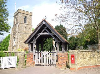
Aldenham is a village and civil parish in the borough of Hertsmere in Hertfordshire, England. The parish includes Radlett and Letchmore Heath as well as Aldenham village itself. The village of Aldenham lies 3.5 miles (5.6 km) north-east of Watford and 2 miles (3.2 km) southwest of Radlett. Aldenham was mentioned in the Domesday Book and is one of Hertsmere's 14 conservation areas. The village has eight pre-19th-century listed buildings and the parish itself is largely unchanged, though buildings have been rebuilt, since Saxon times when the majority of the land was owned by the abbots of Westminster Abbey.
Olton is an area/suburban village within the Metropolitan Borough of Solihull in the West Midlands, England. In the 13th century, the Lords of the Manor moved their seat and formed a new settlement, at the junction of two major roads. It was then that Ulverlei was being referred to as ‘Oulton’ to distinguish itself from nearby Solihull. Historically within the county of Warwickshire, the village has gradually become contiguous with Solihull to the southeast, though it retains the character of a large independent village.

Appleby Magna is a village and civil parish in the North West Leicestershire district, in the county of Leicestershire, England. It includes the small hamlets of Appleby Parva and Little Wigston.

Barton Bendish is a civil parish and small ancient village in the English county of Norfolk located 10 miles (16 km) south of King's Lynn and 90 miles (140 km) North East of London. It has two medieval parish churches, and once had three. The parish includes the old hamlet of Eastmoor, and covers 3,936 acres (1,593 ha). The village has been settled since Neolithic times and was expanded during the Saxon period. Today the village has a population of 210 as recorded at the 2010 census and contains eight listed buildings, with the two medieval parishes churches being Grade I.
West Tisted is a small village in the East Hampshire district of Hampshire, England. It is 6.7 miles (10.8 km) northwest of Petersfield, just off the A32 road.

St Michael's Church is a Church of England parish church in St Albans, Hertfordshire, England. Much of the building is late 10th or early 11th century, making it the most significant surviving Anglo-Saxon building in the county. It is located near the centre of the site of Roman Verulamium to the west of the modern city.

Woodeaton or Wood Eaton is a village and civil parish about 4 miles (6.4 km) northeast of Oxford, England. It also has a special needs school called Woodeaton Manor School.
Beckley is a village in the civil parish of Beckley and Stowood, in the South Oxfordshire district, in the county of Oxfordshire, England. It is about 4.5 miles (7 km) northeast of the centre of Oxford. The 2011 Census recorded the parish of Beckley and Stowood's population as 608. The village is 400 feet (120 m) above sea level on the northern brow of a hill overlooking Otmoor. The hill is the highest part of the parish, rising to 463 feet (141 m) south of the village near Stow Wood. On the eastern brow of the hill is Oxford transmitting station, a television relay mast that is a local landmark. In 1931 the parish of Beckley had a population of 288. On 1 April 1932 the parish was abolished to form "Beckley and Stowood", part also went to "Fencott and Murcott".

Britford is a village and civil parish beside the River Avon about 1.5 miles (2.4 km) south-east of Salisbury in Wiltshire, England. The village is just off the A338 Salisbury-Bournemouth road. The 2011 Census recorded a parish population of 592.

Crowhurst is a village and civil parish in the Tandridge district of Surrey, England. The nearest town is Oxted, 3 miles (5 km) to the north. Rated two architectural categories higher than the medieval church is the Renaissance manor, Crowhurst Place, which is a Grade I listed building.

Wallington is a small village and civil parish in the North Hertfordshire district, in the county of Hertfordshire, England, near the town of Baldock. The population of the civil parish at the 2011 Census was 150. Nearby villages include Rushden and Sandon. It shares a parish council with Rushden.

Matching is a village and civil parish in the Epping Forest district of Essex, England centred in countryside 3 miles (4.8 km) east of Harlow's modern town centre and 2 miles (3.2 km) from Old Harlow/Harlow Mills area of the town. The terrain is elevated and London is centred 21.7 miles (34.9 km) to the south-west.
Northchurch is a village and civil parish in the Bulbourne valley in the county of Hertfordshire in the United Kingdom. It lies between the towns of Berkhamsted and Tring.

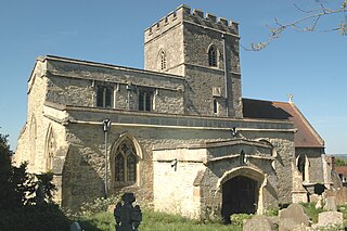
The Church of St Nicholas in Norton in Hertfordshire is the parish church for what was originally the village of Norton but which today has become a suburb of Letchworth Garden City. The present building dates from about 1109 to 1119, with additions in the 15th century including the tower. Before the Reformation it was a stopping point on the pilgrim route to the Abbey of St Albans and the shrine there.

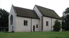
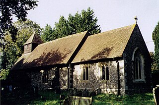
The Church of St Margaret of Antioch is the Anglican parish church for the village of Bygrave in Hertfordshire. Dedicated to St Margaret of Antioch, the church has been a Grade II* listed building since 1968 and comes under the Diocese of St Albans.