
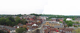
Saint Albans is a cathedral city in Hertfordshire, England, east of Hemel Hempstead and west of Hatfield, 20 miles (32 km) north-west of London, 8 miles (13 km) south-west of Welwyn Garden City and 11 miles (18 km) south-east of Luton. St Albans was the first major town on the old Roman road of Watling Street for travellers heading north and became the city of Verulamium. It is within the London commuter belt and the Greater London Built-up Area.

Welwyn Garden City is a town in Hertfordshire, England, 20 miles (32 km) north of London. It was the second garden city in England and one of the first new towns. It is unique in being both a garden city and a new town and exemplifies the physical, social and cultural planning ideals of the periods in which it was built.
The City and District of St Albans is a local authority district in Hertfordshire in the East of England region. The main urban settlements are St Albans and Harpenden. The council offices are in St Albans.

Harpenden is a town and civil parish in the City and District of St Albans in the county of Hertfordshire, England. The population of the built-up area was 30,240 in the 2011 census, whilst the population of the civil parish was 29,448. Harpenden is a commuter town, with a direct rail connection through Central London and property prices well over triple the national average.
Rickmansworth is a town in southwest Hertfordshire, England, about 17 miles (27 km) northwest of central London and inside the perimeter of the M25 motorway. The town is mainly to the north of the Grand Union Canal and the River Colne. The town of Watford is 5 miles (8 km) to the northeast. Rickmansworth is the administrative seat of the Three Rivers District Council. The confluence of the River Chess and the River Gade with the Colne in Rickmansworth inspired the district's name. The enlarged Colne flows south to form a major tributary of the River Thames. The town is served by the Metropolitan line of the London Underground and Chiltern Railways from London Marylebone to Aylesbury railway station.
Chorleywood is both a village and a civil parish in the Three Rivers District, Hertfordshire, on the border with Buckinghamshire, approximately 20 miles (32 km) northwest of Charing Cross. The village is adjacent to the Chiltern Hills Area of Outstanding Natural Beauty and is part of the London commuter belt included in the government-defined Greater London Urban Area. Chorleywood was historically part of the parish of Rickmansworth, becoming a separate ecclesiastical parish in 1845 and a separate civil parish in 1898. The population of the parish was 11,286 at the 2011 census.

St Albans is a constituency represented in the House of Commons of the UK Parliament since 2019 by Daisy Cooper, a Liberal Democrat.

Welwyn Hatfield is a constituency in Hertfordshire represented in the House of Commons of the UK Parliament since 2005 by Grant Shapps, the Secretary of State for Business, Energy and Industrial Strategy, a Conservative who was previously the Secretary of State for Transport.

Hemel Hempstead is a constituency in Hertfordshire represented in the House of Commons of the Parliament of the United Kingdom. It elects one Member of Parliament (MP) by the first-past-the-post system. Since 2005, it has been represented by Mike Penning, a member of the Conservative Party.

Hitchin and Harpenden is a constituency represented in the House of Commons of the UK Parliament since 2017 by Bim Afolami, a Conservative.

Barnet was a local government district in south Hertfordshire from 1863 to 1965 around the town of Barnet.

Elstree Rural District was a rural district in Hertfordshire, England from 1894 to 1974.

Rothamsted Park is a 56-acre (230,000 m2) public park in Harpenden, Hertfordshire.
Brickendon is a village in the civil parish of Brickendon Liberty in the district of East Hertfordshire about 3 miles (4.8 km) south of the county town Hertford, and is served by Bayford railway station.
St Albans Rural District was a rural district in the administrative county of Hertfordshire, England from 1894 to 1974. It surrounded but did not include the city of St Albans.

Hatfield Rural District was a rural district in Hertfordshire, England, from 1894 to 1974, covering an area in the south of the county.
St Michael is a civil parish part of the City and District of St Albans in Hertfordshire, England. The population in 2001 was 494. The local council is St Michael Parish Council.
Berkhamsted Rural District was a rural district in Hertfordshire, England from 1894 to 1974, covering an area to the west of the county. Until 1937 the official spelling of the district's name was Berkhampstead Rural District.
Welwyn Rural District was a rural district in Hertfordshire, England from 1894 to 1974, covering an area in the centre of the county.
