Stapleford, Hertfordshire

Last updated

Stapleford
St Mary's Church, Stapleford, Hertfordshire 1 2020-08-26.jpg
The church of St Mary, Stapleford
Hertfordshire UK location map.svg
Red pog.svg
Stapleford
Location within Hertfordshire
Population567 (2011 Census including Waterford)
OS grid reference TL310171
Shire county
Region
Country England
Sovereign state United Kingdom
Post town Hertford
Postcode district SG14
Dialling code 01992
Police Hertfordshire
Fire Hertfordshire
Ambulance East of England
List of places
UK
England
Hertfordshire
51°50′10″N0°05′24″W / 51.836°N 00.09°W / 51.836; -00.09

Not to be confused with Stapleford, Nottinghamshire.

Contents

Stapleford is a village and civil parish of 134 acres (54 ha) on the A119 road, in the East Hertfordshire district, in the county of Hertfordshire, England. Stapleford is located between Waterford and Watton-at-Stone in the Beane valley; the little river was forded at this point, giving rise to the village. Stapleford's parish church is St Mary's Church. [1] Beane is a hamlet of Stapleford.[ citation needed ]

History

The placename occurs as Stapelford in an Exchequer document of 1210, lending weight to Walter William Skeat's suggestion that the ford site was marked by an upright stake, in Anglo-Saxon stapel. [2]

In the early 1970s, John Marius Wilson described Stapleford as:

"a parish in the district and county of Hertford; 2¾ miles N of Hertford r. station. It has a post-office under Hertford. Acres, 1,319. Real property, £1,622. Pop., 226. Houses, 45. The property is all in one estate. The living is a rectory in the diocese of Rochester. Value, £280.* Patron, A Smith, Esq. The church was repaired and enlarged in 1852. There is a national school. [3]

In 1831, majority of males were labourers and servants whilst the remaining were employers and professionals or into middling sorts or other occupations, this shows the social status of males in Stapleford during those times. [4]

Stapleford's population is 567 according to 2011 census which includes 286 males and 281 females. [5]

Statistics

In the 1880s majority of the men's occupation was within agriculture, whereas women were more into the domestic service. The professional occupation had the fewest people working within that sector for both genders. [6] According to the Office of National Statistics, [7] 67% of Stapleford's population are Christian.The following 26% classify themselves as nonreligious, 5% did not state their religious preference and the rest are the other religions. The village has many churches to accommodate to the Christians.The Office of National Statistics [8] show that the people of Stapleford generally have very good health with 299 out of 567 classified as having very good health and the next big group having good health. As a whole the health rate is high, despite the 18 individuals who either have bad health or very bad health. The health rate in this area suggests that the village has very good health care sector. Lastly, information published by the 2011 Census stated that the largest ethnic group is White British, as [9] 537 out of 567 people are of this ethnicity showing that the village is not multicultural.

Map of Stapleford, Ordnance Survey of Great Britain New Popular Edition,160 Stapleford Map.PNG
Map of Stapleford, Ordnance Survey of Great Britain New Popular Edition,160

Occupation

From the Occupational Structure of Males Pie Chart, it is seen that during 1881, 57% of the men's occupation was within agriculture showing that the area was rural. There were other occupations during that time but not as major as the agricultural sector. Within the Occupational structure for Females, 51% are in an Unknown Occupation this is most likely classified as being a Housewife which would be common during these times, as majority of other work was very physical, thus the demanding jobs would be for men. The next sector with the highest percentage of females was within Domestic Service.

Occupational Structure of Males reported by the census reports from Vision of Britain 1881 Occupational Structure of Males in Stapleford.png
Occupational Structure of Males reported by the census reports from Vision of Britain
Occupational Structure of Females reported by the census reports from Vision of Britain 1881 Occupational Structure of Females in Stapleford.png
Occupational Structure of Females reported by the census reports from Vision of Britain

Population

Census reports [10] from 1880s to 2011 have illustrated within the "Total Population of Stapleford" graph that during 1880 to 1920 population growth was reasonably stable within 200 people. Thereafter, population growth increased by more than a half to 500 people by 1960 and then by 2011 increased by less than 100 people to reach the 2011 population of 567 people.

The population demographic in Stapleford has seen in the past the:

mortality decline in the late 19th century was mainly due to the reduction of very high infant mortality rates: the presence or absence of large number of infants dying before their first birthday had little effect on overall age structures. During the twentieth century, declining fertility and improved life expectancy in later life significantly changed age structures. [11]

Total population of Stapleford Parish, Hertfordshire, as reported by the Census of Population from 1881 to 2011 Stapleford Population Time series from 1881-2011.jpg
Total population of Stapleford Parish, Hertfordshire, as reported by the Census of Population from 1881 to 2011

Transport

For transportation, the village has to rely on cars or vans, however, in the past Stapleford, had a railway station for 15 years which made transportation easier, but had to close down due to accidents and incidents occurring. 2011 census data shows that only 19 out of 229 households do not have a car or van. On the other hand, the remaining households do have 1 or more cars, with 105 households having 2 cars or vans. [12]

Economy

The economic activity within Stapleford of 2011 according to National Statistics shows that females [13] of working age which is 24% of them were in part-time work whilst for full-time had 28%, 9% were in self-employment, 37% were economically inactive and around 2% of the population were unemployed. The case is different for men in this village as [14] 80% of them were economically active. In terms of housing, the Village of Stapleford generally live in a whole house or bungalow as stated from the Office of National Statistics. [15]

Places of interest

St Mary's Church Stapleford

This beautiful and historic church is part of the diocese of St Albans and marks special important events from baptisms to weddings. The church has a sense of community as church members can find out about village events by the Parish News that is released monthly. The Church school, though small is highly successful and involved in Church life. [16] St Mary's is located on Church Lane and is open at weekends during daylight hours. [17]

See also

Related Research Articles

<span class="mw-page-title-main">Cratfield</span> Human settlement in England

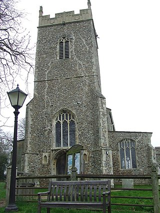
Cratfield is a village in northern Suffolk, England. "It has a population of 292 according to the 2011 census." Neighbouring villages include Laxfield, Metfield, Cookley, Huntingfield, Heveningham. The nearest town, Halesworth, is approximately 6.7 miles (10.7 km) away. Southwold is a popular, nearby coastal town. The market town of Framlingham is also close by.

<span class="mw-page-title-main">Acton Turville</span> Human settlement in England

Acton Turville is a parish in the Cotswold Edge ward within South Gloucestershire, England. It lies 17 miles (27 km) east-northeast of Bristol and 93 miles (150 km) due west of London, with the M4 south of the parish. Acton Turville consists of a cluster of households across 1,009 acres, with a total population of 370 people. Acton Turville is also listed as "Achetone" in the Domesday Book.

<span class="mw-page-title-main">Easton, Cambridgeshire</span> Human settlement in England

Easton is a village and civil parish in Cambridgeshire, England. Easton lies approximately 6 miles (10 km) west of Huntingdon, between the villages of Ellington and Spaldwick. Easton is situated within Huntingdonshire which is a non-metropolitan district of Cambridgeshire as well as being a historic county of England. Easton is a hamlet which the Anglo Saxons settled in.

<span class="mw-page-title-main">Barkby</span> Human settlement in England

Barkby is a village and civil parish in the Charnwood district of Leicestershire, England. It is situated north-east of Leicester, and only a short way from Leicester's urban sprawl in Thurmaston and Syston. Nearby villages are Beeby and Barkby Thorpe. Barkby Brook is the main watercourse which flows through Barkby. The parish has a population of around 300.

<span class="mw-page-title-main">Rickinghall Inferior</span> Human settlement in England

Rickinghall Inferior is a civil parish in the Mid Suffolk district of Suffolk, England. According to the 2011 census there were 233 males and 216 females in this civil parish, for a total population of 449. It includes the western part of the village of Rickinghall and is adjacent to the village and parish of Wattisfield. The old road from the market town of Bury. St Edmunds to the City of Norwich and the town of Great Yarmouth passes through the centre of the village but the new road, the A143, uses a by-pass to the East.

<span class="mw-page-title-main">Aston, Hertfordshire</span>

Aston is a village and civil parish in the East Hertfordshire district of Hertfordshire, England. According to the 2001 census it had a population of 844, increasing to 871 at the 2011 Census. Located on a ridge between Stevenage and the Beane Valley, Aston is a 10 minutes drive from the A1(M).

<span class="mw-page-title-main">Beighton, Norfolk</span> Village and civil parish in the Broadland district of Norfolk, England

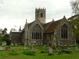
Beighton is a village and civil parish in the Broadland district of Norfolk, England, about two miles (3 km) South-West of Acle about 12.8 miles (20.6 km) to Norwich. It covers an area of 7.63 km2 and has a population of 436 in 185 households according to the 2011 census. Today, Beighton incorporates the old parish of Moulton St Mary, and both parishes are mentioned in the Domesday Book of 1086. The All Saints church is situated within Beighton, along Church Hill. The church was described in 1870 as:

The church is decorated English, and was recently restored.

<span class="mw-page-title-main">Belstead</span> Human settlement in England

Belstead is a village and civil parish in the Babergh district of the English county of Suffolk. Located on the southern edge of Ipswich, around 3 miles (5 km) south-west of Ipswich town centre. It had a population of 202 according to the 2011 census. Belstead has amenities such as a village hall, St Mary's the Virgin Church, The bridge school for children with learning difficulties and Belstead Brook Hotel and Spa. It is in the Belstead Brook electoral division of Suffolk County Council.

<span class="mw-page-title-main">Sundridge with Ide Hill</span> Human settlement in England

Sundridge and Ide Hill is a civil parish in the Sevenoaks District of Kent, England. It is located in the Darenth valley and lies between Sevenoaks and Westerham. The parish contains the villages of Sundridge and Ide Hill and the hamlet of Goathurst Common. It lies within the Kent Downs Area of Outstanding Natural Beauty and within London’s Metropolitan Green Belt. It is approximately 21 miles south of London.

<span class="mw-page-title-main">Parham, Suffolk</span> Village and civil parish in Suffolk, England

Parham is a village and civil parish in the East Suffolk district of Suffolk in eastern England. Located seven miles north of Woodbridge, in 2005 it had a population of 300, reducing to 263 at the 2011 census and according to the 2011 census there were 129 males and 134 females living at this time.

<span class="mw-page-title-main">Brent Eleigh</span> Human settlement in England

Brent Eleigh is a village and civil parish in the Babergh district of Suffolk, England. Located between Hadleigh and Lavenham, in 2005 it had a population of 180 reducing to 174 at the 2011 census.

<span class="mw-page-title-main">Nether Langwith</span> Human settlement in England

Nether Langwith is a village and civil parish, in the Bassetlaw district of Nottinghamshire, England. It is located 9 miles (14 km) east of Chesterfield and 8 miles (13 km) south west of Worksop. Nether Langwith lies east of the adjoining village, Langwith, which is in the district of Bolsover, Derbyshire, England. It is 527 hectares in size and lies on the banks of the River Poulter. The population at the 2011 census was 526.

<span class="mw-page-title-main">Heveningham</span> Village in Suffolk, England

Heveningham is a village and civil parish in the East Suffolk district of Suffolk in eastern England. Located four miles south-west of Halesworth, in 2005 it had a population of 120.

<span class="mw-page-title-main">Stocking Pelham</span> Human settlement in England

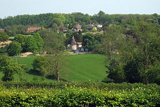
Stocking Pelham is a village and civil parish in the East Hertfordshire district of Hertfordshire, England. It is located on the border with Essex, around 6 miles (10 km) east of Buntingford.The village is one of the three Pelhams, along with the nearby Brent Pelham and Furneux Pelham. Stocking Pelham is home to St. Mary's Church in the Church of England Diocese of St Albans. The aerial view of Stocking Pelham shows that the settlements are sparsely positioned from one another. Close by the village is a major electrical substation of the National Grid.

<span class="mw-page-title-main">Clopton, Suffolk</span> Human settlement in England

Clopton is a village and civil parish in Suffolk. It is located between Ipswich and Debenham two kilometres north of Grundisburgh on the River Lark. The village is no larger than a series of houses either side of the B1078, surrounded by farm land. The village itself has no clear centre; houses and other buildings are concentrated around the four manors of Kingshall, Brendhall, Rousehall and Wascolies, all of which are mentioned in the Domesday Book of 1086.

<span class="mw-page-title-main">Great Livermere</span> Human settlement in England

Great Livermere is a village and civil parish in the West Suffolk district of Suffolk in eastern England. It is located around four miles north-east of the borough's largest town Bury St Edmunds.

<span class="mw-page-title-main">Withersfield</span> Human settlement in England

Withersfield is a village and civil parish in the West Suffolk district of Suffolk in eastern England. In 2011 its population was 450. It has a public house and a village hall, and centres on the parish church, St. Mary the Virgin. It is in a rural location, surrounded by farmland, yet only a mile north of the busy market town of Haverhill. Surrounding villages include Great Wratting, West Wickham and Great Thurlow.

<span class="mw-page-title-main">Tugby and Keythorpe</span> Human settlement in England

Tugby and Keythorpe is a civil parish comprising the village of Tugby and land surrounding Keythorpe Hall, Hall Farm and Lodge Farm in Leicestershire, England, part of the Harborough district. The Parish covers around 2,200 acres, situated 7 miles west of Uppingham, and 12 miles east of Leicester. According to the 2011 census the population of the parish was 330. The Anglican parish register for the parish dates back to 1568. The boundaries of the parish have not changed throughout the years, meaning that the parish's size remains the same as it did in 1568.

<span class="mw-page-title-main">Great Moulton</span> Human settlement in England

Great Moulton is a civil parish in the English county of Norfolk. Until the 16th century it also included the Little Moulton parish.

<span class="mw-page-title-main">Huntingfield, Suffolk</span> Human settlement in England

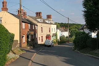
Huntingfield is a village near the B1117 road, in the East Suffolk district, in the county of Suffolk, England. The village is close to the source of the River Blyth and the parish is 12 miles from the seaside town of Southwold. Nearby settlements include the town of Halesworth and the villages of Walpole, Heveningham, Cookley and Laxfield.

References

  1. A Church Near You St Mary's Stapleford
  2. Skeat, The Place-names of Hertfordshire, 1904:27f.
  3. Wilson, John Marius (1887). Imperial Gazetteer of England and Wales. Edinburgh: A. Fullerton & Co. Retrieved 24 March 2016.
  4. "Social Structure in 1831". A Vision of Britain through time. GB Historical GIS / University of Portsmouth. Retrieved 24 April 2016.
  5. "Stapleford: Key Figures for 2011 Census:Key Statistics". Neighbourhood Statistics. Office for National Statistics. Retrieved 28 January 2016.
  6. "1880 Occupations". A Vision of Britain through Time. GB Historical GIS / University of Portsmouth. Retrieved 24 April 2016.
  7. "Religion, 2011, Stapleford". Office for National Statistics.
  8. "General Health 2011". General Health,2011, Stapleford.
  9. "Ethnicity Group, Office for National Statistics".
  10. "Table View of Population".
  11. Bartholomew, John (1887). Gazetteer of the British Isles (1st ed.). Edinburgh: Bartholomew.
  12. "Car or Van Availability, 2011". Neighbourhood Statistics. Office for National Statistics. Retrieved 30 March 2016.
  13. "Economic Activity, Females,Neighbourhood Statistics". Neighbourhood Statistics. Office for National Statistics. Retrieved 24 March 2016.
  14. "Economic Activity,Males 2011, Office for National Statistics". Office for National Statistics.
  15. "Housing". Neighbourhood Statistics. Office for National Statistics. Retrieved 24 April 2016.
  16. "St Mary's Church" . Retrieved 25 April 2016.
  17. "Info about St Marys" . Retrieved 25 April 2016.