Related Research Articles

An earthquake – also called a quake, tremor, or temblor – is the shaking of the Earth's surface resulting from a sudden release of energy in the lithosphere that creates seismic waves. Earthquakes can range in intensity, from those so weak they cannot be felt, to those violent enough to propel objects and people into the air, damage critical infrastructure, and wreak destruction across entire cities. The seismic activity of an area is the frequency, type, and size of earthquakes experienced over a particular time. The seismicity at a particular location in the Earth is the average rate of seismic energy release per unit volume.

The San Andreas Fault is a continental right-lateral strike-slip transform fault that extends roughly 1,200 kilometers (750 mi) through the U.S. state of California. It forms part of the tectonic boundary between the Pacific Plate and the North American Plate. Traditionally, for scientific purposes, the fault has been classified into three main segments, each with different characteristics and a different degree of earthquake risk. The average slip rate along the entire fault ranges from 20 to 35 mm per year.

Engineering geology is the application of geology to engineering study for the purpose of assuring that the geological factors regarding the location, design, construction, operation and maintenance of engineering works are recognized and accounted for. Engineering geologists provide geological and geotechnical recommendations, analysis, and design associated with human development and various types of structures. The realm of the engineering geologist is essentially in the area of earth-structure interactions, or investigation of how the earth or earth processes impact human made structures and human activities.
The Alquist-Priolo Earthquake Fault Zoning Act was signed into California law on December 22, 1972, to mitigate the hazard of surface faulting to structures for human occupancy.

The Hayward Fault Zone is a right-lateral strike-slip geologic fault zone capable of generating destructive earthquakes. The fault was first named in the Lawson Report of the 1906 San Francisco Earthquake in recognition of its involvement in the earthquake of 1868. This fault is about 119 km (74 mi) long, situated mainly along the western base of the hills on the east side of San Francisco Bay. It runs through densely populated areas, including Richmond, El Cerrito, Berkeley, Oakland, San Leandro, Castro Valley, Hayward, Union City, Fremont, and San Jose.

The California Geological Survey, previously known as the California Division of Mines and Geology, is the California state geologic agency.

Coyote Creek is a river that flows through the Santa Clara Valley in Northern California. Its source is on Mount Sizer, in the mountains east of Morgan Hill. It eventually flows into Anderson Lake in Morgan Hill and then northwards through Coyote Valley to San Jose, where it empties into San Francisco Bay.

Bruce Bolt was an Australian-born American seismologist and a professor of earth and planetary science at the University of California, Berkeley. Professor Bolt was known as a pioneer of seismic engineering. He served for 15 years on the California Seismic Safety Commission leading public debate on earthquake safety in that state, and acted as a consultant on major projects throughout the world. As well, Bolt published a number of popular and technical books on seismology.
The Seismic Hazard Mapping Act was enacted by the California legislature in 1990 following the Loma Prieta earthquake of 1989. The Act requires the California State Geologist to create maps delineating zones where data suggest amplified ground shaking, liquefaction, or earthquake-induced landsliding may occur.
The California Department of Conservation is a department within the government of California, belonging to the California Natural Resources Agency. With a team of scientists, engineers, environmental experts, and other specialists, the Department of Conservation administers a variety of programs vital to California's public safety, environment and economy. The department's mission is to manage California's working lands. It regulates oil, natural gas and geothermal wells; studies and maps earthquakes and other geologic phenomena; maps and classifies areas containing mineral deposits; ensures reclamation of land used for mining; and administers agricultural and open-space land conservation programs. A division within the department dedicated to encouraging beverage container recycling has been moved into the newly created Department of Resources Recovery and Recycling (CalRecycle). Despite the similar name, the Department of Conservation should not be confused with the California Conservation Corps, another department within the Natural Resources Agency, which provides work experience for young adults. The Department of Conservation often collaborates with its federal equivalents, such as the U.S. Geological Survey.

California is a unique place that has not always been well understood. For hundreds of years there persisted a European misconception that California was an island and many maps were made depicting it as such. Eventually, by the 18th century, enough information about California reached the outside world to dispel that myth. As California became increasingly populated, comprehensive surveying and mapping of its territory seemingly expanded slowly. When gold was discovered in 1848 and it joined the United States as the thirty first state in 1851 and interest in plotting California's landscapes boomed.
The 1992 Cape Mendocino earthquakes occurred along the Lost Coast of Northern California on April 25 and 26. The three largest events were the M7.2 thrust mainshock that struck near the unincorporated community of Petrolia midday on April 25 and two primary strike-slip aftershocks measuring 6.5 and 6.6 that followed early the next morning. The sequence encompassed both interplate and intraplate activity that was associated with the Mendocino Triple Junction, a complex system of three major faults that converge near Cape Mendocino. The total number of aftershocks that followed the events exceeded 2,000.

A hazard map is a map that highlights areas that are affected by or are vulnerable to a particular hazard. They are typically created for natural hazards, such as earthquakes, volcanoes, landslides, flooding and tsunamis. Hazard maps help prevent serious damage and deaths.
Diablo Canyon (Nuclear) Power Plant, located in San Luis Obispo County California, was originally designed to withstand a 6.75 magnitude earthquake from four faults, including the nearby San Andreas and Hosgri faults, but was later upgraded to withstand a 7.5 magnitude quake. It has redundant seismic monitoring and a safety system designed to shut it down promptly in the event of significant ground motion.

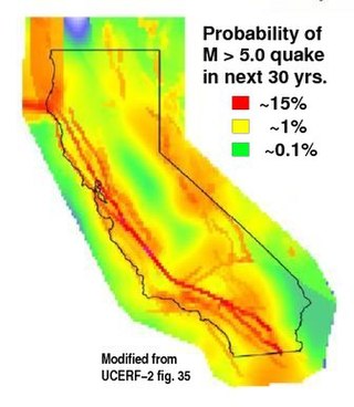
The 2008 Uniform California Earthquake Rupture Forecast, Version 2, or UCERF2, is one of a series of earthquake forecasts prepared for the state California by the Working Group on California Earthquake Probabilities (WGCEP), collaboration of the U.S. Geological Survey, the California Geological Survey, and the Southern California Earthquake Center, with funding from the California Earthquake Authority. UCERF2 was superseded by UCERF3 in 2015.

The 2015 Uniform California Earthquake Rupture Forecast, Version 3, or UCERF3, is the latest official earthquake rupture forecast (ERF) for the state of California, superseding UCERF2. It provides authoritative estimates of the likelihood and severity of potentially damaging earthquake ruptures in the long- and near-term. Combining this with ground motion models produces estimates of the severity of ground shaking that can be expected during a given period, and of the threat to the built environment. This information is used to inform engineering design and building codes, planning for disaster, and evaluating whether earthquake insurance premiums are sufficient for the prospective losses. A variety of hazard metrics can be calculated with UCERF3; a typical metric is the likelihood of a magnitude M 6.7 earthquake in the 30 years since 2014.
Joan S. Gomberg is a research geophysicist at the United States Geological Survey. She serves as an adjunct professor at the University of Washington. She is interested in subduction zone science, and studies how earthquakes trigger each other and how faults can slip. Gomberg is a Fellow of the American Geophysical Union. She was the first person to demonstrate how dynamic stress associated with seismic waves can trigger other earthquakes.
The Lompoc earthquake of 1927 occurred at 5:49 a.m. Pacific Standard Time (PST), on November 4 with an epicenter off the coast of Lompoc, Santa Barbara County in Southern California. It is one of the largest earthquakes to have occurred off the coast of California, measuring a surface-wave magnitude of 7.3. The earthquake may have originated along the Hosgri Fault, an entirely offshore structure. Shaking from the earthquake and an unusually large tsunami caused some damage to communities near the earthquake. Due to its location and the area being sparsely populated at the time, there were no human fatalities reported. It is the only California-generated tsunami recorded in Hawaii.
Kate E. Allstadt is a geologist and seismologist employed by the U.S. Geological Survey (USGS) who works out of Golden, Colorado. She is a self-described "present-day geologist" for her interest in connections between geology of the Pacific Northwest and the people in its local communities. She is a published expert on the 2014 Oso landslide.
References
- ↑ "Welcome to the California Geological Survey". California Geological Survey. Retrieved 3 March 2012.
- 1 2 3 Smith, Theodore C.; McKamey, Bea (2000). "Summary of outreach activities for California's Seismic Hazards Mapping Program, 1996–1998". California Division of Mines and Geology Special Publication 121.
- ↑ "Forest and Watershed Geology Program". California Geological Survey. Archived from the original on 28 September 2012. Retrieved 3 March 2012.
- ↑ "Landslides". California Geological Survey. Archived from the original on 27 February 2012. Retrieved 3 March 2012.
- ↑ "Forest and Watershed Geology Program". California Geological Survey. Archived from the original on 2012-03-14. Retrieved 2012-03-03.
- ↑ Beuter, Thomas. "A brief history of the Ocean Shore Railroad". San Francisco Trains. Retrieved 3 March 2012.
- ↑ Ellen, S.D.; Wieczorek, G.F. (1988). "Landslides, floods, and marine effects of the storm of January 3–5, 1982, in the San Francisco Bay region, California" (PDF). U.S. Geological Survey Professional Paper (1434).
- ↑ Smith, T.C.; Hart, E.W. (July 1982). "Landslides and related storm damage, January 1982, San Francisco Bay region". California Geology. 35 (7): 139–152.
- ↑ Jones, Donna (January 6, 2012). "Devastating disaster: Storm of 1982 left 22 dead, many more homeless". Santa Cruz Sentinel .
- ↑ Jibson, Randall W. (2005). "Landslide Hazards at La Conchita, California". U.S. Geological Survey Open File Report 05-1067. Retrieved 3 March 2012.