Cedar Mountain (Wyoming)

Last updated
Cedar Mountain
Cedar Mountain, Buffalo Bill Reservoir.jpg
West aspect
Highest point
Elevation 7,880 ft (2,400 m) [1]
Prominence 2,460 ft (750 m) [1]
Parent peak Rattlesnake Mountain [2]
Isolation 4.97 mi (8.00 km) [2]
Coordinates 44°29′42″N109°09′45″W / 44.49500°N 109.16250°W / 44.49500; -109.16250 Coordinates: 44°29′42″N109°09′45″W / 44.49500°N 109.16250°W / 44.49500; -109.16250 [3]
Geography
USA Wyoming location map.svg
Red triangle with thick white border.svg
Cedar Mountain
Location in Wyoming
Usa edcp relief location map.png
Red triangle with thick white border.svg
Cedar Mountain
Cedar Mountain (the United States)
Location Park County, Wyoming, U.S.
Parent range Absaroka Range
Rocky Mountains
Topo map USGS Irma Flats
Geology
Type of rock volcanic breccia
Climbing
Easiest route class 1 hiking [2]

Cedar Mountain, also known as Spirit Mountain, is a prominent 7,880-foot-elevation (2,400-meter) summit located in Park County, Wyoming, United States. [3] [4]

Contents

Description

The peak is situated immediately west of the town of Cody. It is set in the Absaroka Range at the western edge of the Bighorn Basin. Topographic relief is significant as the west aspect rises 2,500 feet (760 meters) above Buffalo Bill Reservoir in one mile. The Cedar Mountain name has been officially adopted by the United States Board on Geographic Names. [3]

Buffalo Bill

Buffalo Bill was a world-famous resident and founder of Cody, and in his 1906 will requested to be buried on Cedar Mountain, with a buffalo monument marking the spot and overlooking the town. He was in Denver when he died in 1917. In a subsequent 1913 will, he left his burial arrangements to his wife. She accepted a monetary offer from the city of Denver and Denver Post newspaper to have him buried in the Denver area to serve as a tourist attraction. She said he wanted to be buried on Lookout Mountain, in Golden, Colorado, west of Denver, which was corroborated by their daughter Irma, Cody's sisters, and family friends. But other family members joined the people of Cody in saying that he should be buried in the town he founded. A story has it that the enraged people of Cody spirited away his body from the Denver mortuary in an elaborate ruse, and buried him on Cedar Mountain. [5] Whether or not he is secretly buried on Cedar Mountain, a buffalo monument is erected there.

Climate

According to the Köppen climate classification system, Cedar Mountain is located in a semi-arid climate zone with cold, snowy winters, and cool to warm summers. [6] Precipitation runoff from the mountain drains into the Shoshone River.

Cody, Cedar Mountain (left), Rattlesnake Mountain (right) Cody, Wyoming.jpg
Cody, Cedar Mountain (left), Rattlesnake Mountain (right)

See also

Related Research Articles

<span class="mw-page-title-main">Dome Mountain (Wyoming)</span> Mountain in Wyoming, United States

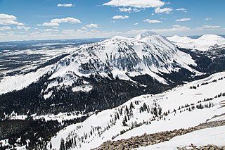
Dome Mountain, elevation 9,903 feet (3,018 m), is a mountain peak in the southern section of the Gallatin Range in Yellowstone National Park, in the U.S. state of Wyoming.

<span class="mw-page-title-main">Three Rivers Peak</span> Mountain in Wyoming, United States

Three Rivers Peak is a 9,958-foot (3,035 m) mountain summit in the southern section of the Gallatin Range in Yellowstone National Park, in the U.S. state of Wyoming.

<span class="mw-page-title-main">Hoyt Peak</span> Summit in Yellowstone National Park, Wyoming

Hoyt Peak is a 10,506 feet (3,202 m) summit located on the shared border of Yellowstone National Park and North Absaroka Wilderness, in Park County, Wyoming.

<span class="mw-page-title-main">Pilot Peak (Wyoming)</span> Mountain in Wyoming, United States

Pilot Peak, elevation 11,699 feet (3,566 m), is a prominent mountain peak in the Absaroka Range in Park County, Wyoming. The peak is visible from US Route 212, the Beartooth Highway just east of the Northeast Entrance Station to Yellowstone National Park. Index Peak rises just north of Pilot Peak.

<span class="mw-page-title-main">Avalanche Peak (Wyoming)</span> Mountain

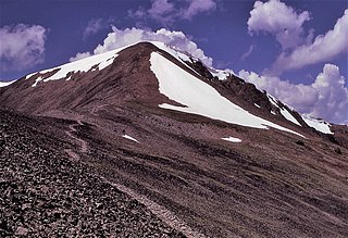
Avalanche Peak is a 10,568-foot (3,221 m) summit located on the shared border of Yellowstone National Park and North Absaroka Wilderness, in Park County, Wyoming. It is part of the Absaroka Range. It features a large bowl covered in scree and is popular with hikers for its view of Yellowstone Lake and the surrounding area. The mountain's name was officially adopted in 1930 by the United States Board on Geographic Names.

<span class="mw-page-title-main">Feather Peak</span> Mountain in California, United States

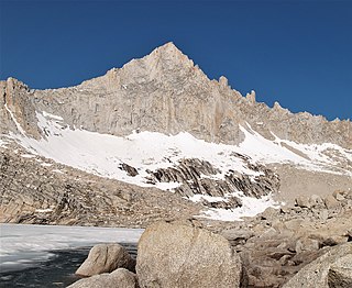
Feather Peak is a 13,240-foot-elevation mountain summit located west of the Royce Lakes in the Sierra Nevada mountain range in northern California, United States. It is situated in Fresno County, in the John Muir Wilderness, on land managed by Sierra National Forest. It is set 3.2 miles east-northeast of Seven Gables, and 0.66 miles (1.06 km) northwest of Royce Peak, which is the nearest higher neighbor. Feather Peak is the 99th highest summit in California. The first ascent of the summit was made in July 1933 by David Brower, who also named this peak.

<span class="mw-page-title-main">Ramshorn Peak</span>

Ramshorn Peak is an 11,635-foot-elevation (3,546-meter) mountain summit located in Fremont County of Wyoming, United States.

<span class="mw-page-title-main">Amphitheater Mountain (Wyoming)</span>

Amphitheater Mountain is a prominent 11,042-foot-elevation (3,366-meter) mountain summit located in Park County, Wyoming, United States.

<span class="mw-page-title-main">Pollux Peak</span>

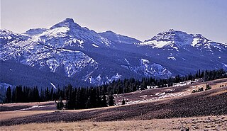
Pollux Peak is an 11,063-foot-elevation (3,372-meter) mountain summit located in Yellowstone National Park, in Park County, Wyoming, United States.

<span class="mw-page-title-main">Saddle Mountain (Wyoming)</span>

Saddle Mountain is a 10,670-foot-elevation (3,250-meter) mountain summit located in Yellowstone National Park, in Park County, Wyoming, United States.

<span class="mw-page-title-main">Top Notch Peak</span>

Top Notch Peak is a 10,245-foot-elevation (3,123 meter) mountain summit located in Yellowstone National Park, in Park County, Wyoming, United States.

<span class="mw-page-title-main">Hoodoo Peak (Wyoming)</span>

Hoodoo Peak is a 10,571-foot-elevation (3,222-meter) mountain summit located in Park County, Wyoming, United States.

<span class="mw-page-title-main">Crystal Peak (Olympic Mountains)</span> Mountain in Washington (state), United States

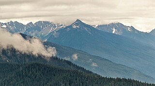
Crystal Peak is a 6,896-foot-elevation (2,102-meter) mountain summit located within Olympic National Park in Jefferson County of Washington state. Crystal Peak is situated two miles north of Enchanted Valley, near the heads of Hayes River and Quinault River. Topographic relief is significant as the northeast aspect rises 3,300 feet above Hayes River in less than one mile. Precipitation runoff from the mountain drains north to the Elwha River via Hayes River and Godkin Creek. Neighbors include line parent Chimney Peak, 2.2 mi (3.5 km) to the south, and proximate parent West Peak, 2.0 mi (3.2 km) to the east. The lower slopes of the mountain are surrounded by Western Red Cedar, Sitka Spruce, Western Hemlock, Alaskan Cedar, Mountain Hemlock, and Douglas-fir of the Quinault Rainforest.

<span class="mw-page-title-main">Mount Norton</span> Mountain in Washington (state), United States

Mount Norton is a 6,397-foot-elevation (1,950-meter) mountain summit located in the Olympic Mountains in Jefferson County of Washington state. It is situated within Olympic National Park, and is set within the Daniel J. Evans Wilderness. Precipitation runoff from the mountain drains north via the Elwha River and Hayes River. Topographic relief is significant as the east aspect rises 3,200 feet above Hayes River in less than one mile, and the west aspect rises 4,400 feet above the Elwha valley in two miles. The lower slopes of the mountain are surrounded by forests of Western Red Cedar, Sitka Spruce, Western Hemlock, Alaskan Cedar, Mountain Hemlock, and Douglas-fir.

<span class="mw-page-title-main">Ostler Peak</span>

Ostler Peak is a 12,718-foot elevation (3,876 m) mountain summit located in Summit County, Utah, United States.

<span class="mw-page-title-main">Mount Lovenia</span>

Mount Lovenia is a 13,219-foot elevation (4,029 m) mountain summit located on the common border that Duchesne County shares with Summit County in the U.S. state of Utah.

<span class="mw-page-title-main">Explorer Peak</span> Mountain in Utah, United States

Explorer Peak is a 12,708-foot elevation (3,873 m) mountain summit located in Duchesne County, Utah, United States.

<span class="mw-page-title-main">Dead Horse Peak</span>

Dead Horse Peak is a 12,642-foot elevation (3,853 m) mountain summit located on the common border that Duchesne County shares with Summit County in the U.S. state of Utah.

<span class="mw-page-title-main">Yard Peak</span>

Yard Peak is a 12,706-foot elevation (3,873 m) mountain summit located on the common border that Duchesne County shares with Summit County in the U.S. state of Utah.

<span class="mw-page-title-main">Mount Beulah</span>

Mount Beulah is a 12,557-foot elevation (3,827 m) mountain summit located in Summit County, Utah, United States.

References

  1. 1 2 "Cedar Mountain, Wyoming". Peakbagger.com. Retrieved 2021-08-06.
  2. 1 2 3 "Cedar Mountain - 7,890' WY". listsofjohn.com. Retrieved 2021-08-06.
  3. 1 2 3 "Cedar Mountain". Geographic Names Information System . United States Geological Survey, United States Department of the Interior . Retrieved 2021-08-06.
  4. Jeff Barnes, The Great Plains Guide to Buffalo Billl, 2014, Stackpole Books, ISBN   9780811712934, page 189.
  5. Lew Freedman, Buffalo Bill Cody: The Man Who Shaped the Wild West Legend, 2020, McFarland Incorporated Publishers, ISBN   9781476640068, pages 195, 200.
  6. Peel, M. C.; Finlayson, B. L.; McMahon, T. A. (2007). "Updated world map of the Köppen-Geiger climate classification". Hydrology and Earth System Sciences. 11 (5): 1633–1644. doi: 10.5194/hess-11-1633-2007 .