
East Windsor is a town in Hartford County, Connecticut, United States. The town is part of the Capitol Planning Region. The population was 11,190 at the 2020 census. The town has five villages: Broad Brook, Melrose, Scantic, Warehouse Point and Windsorville.

U.S. Route 5 (US 5) is a north–south United States Numbered Highway running through the New England states of Connecticut, Massachusetts, and Vermont. Significant cities along the route include New Haven, Connecticut; Hartford, Connecticut; and Springfield, Massachusetts. From Hartford northward to St. Johnsbury, Vermont, the road closely follows the route of the Connecticut River.

Route 20 is a 31.56-mile (50.79 km) state highway in the U.S. state of Connecticut. It extends from Route 8 in rural Winchester to Interstate 91 (I-91) in Windsor Locks. Route 20 consists of two distinct sections: a long, winding, scenic rural road, and a section of the freeway linking I-91 to Bradley International Airport.
Route 159 is a 21.14-mile-long (34.02 km) state highway connecting the Hartford and Springfield areas in the U.S. states of Connecticut and Massachusetts. It begins at the Hartford–Windsor town line and proceeds northward along the west bank of the Connecticut River towards Agawam, Massachusetts. The route ends at the junction of Route 147 and Route 75 in Agawam center just south of the West Springfield city line. The route was originally designated as U.S. Route 5A in 1932 and was renumbered to its modern designation in October 1968.

Route 75 in the U.S. states of Connecticut and Massachusetts is a 17.5-mile-long (28.2 km) scenic route connecting the Hartford, Connecticut, and Springfield, Massachusetts, areas. The route begins at Route 159 in the town of Windsor, Connecticut, and ends at the junction of Route 159/Route 147 in the city of Agawam, Massachusetts.

Route 83 is a 35.65-mile-long (57.37 km) north–south state highway in the Greater Hartford and Greater Springfield areas of the U.S. states of Connecticut and Massachusetts. It serves as the main north–south artery for the towns of Manchester, Vernon, Ellington, and Somers, and continues through East Longmeadow center into downtown Springfield. The route in Massachusetts is town-maintained, except for the ramps connecting to U.S. Route 5 parallel to Interstate 91.

The Scantic River is a river that flows through the states of Massachusetts and Connecticut. It is a tributary to the Connecticut River.
Route 150 is a state highway in southern Connecticut running for 9.04 miles (14.55 km) from the village of Northford, in the town of North Branford, through the center of Wallingford, to the village of Yalesville in Wallingford.

Route 74 is a state highway in Connecticut in the eastern part of the Greater Hartford area. It runs from Route 194 in South Windsor to US 44 in Ashford, going through the towns of Ellington, Vernon, Tolland, and Willington. East of its junction with I-84, it becomes a rural collector road.

Route 140 is a state highway in Connecticut in the northeastern part of the Greater Hartford area. Route 140 is a main artery connecting the town of Stafford to Windsor Locks.
Route 73 is an east–west state highway in Connecticut connecting the town center of Watertown to the Route 8 expressway in Waterbury via the village of Oakville. The road is classified as an urban principal arterial road and carries traffic volumes of about 16,400 vehicles per day.

Melrose is a rural village in northeastern East Windsor, Connecticut. Centered at the crossroads of Broad Brook Road and Melrose Road, it was settled in the 1700s and developed as an agrarian village center in the 19th century. A landscape of more than 250 acres (100 ha), including farmland, period farmhouses, ruins of a small distillery, and a district schoolhouse was listed on the National Register of Historic Places in 2010.
U.S. Route 5 (US 5), a north–south United States Numbered Highway that is generally paralleled by Interstate 91 (I-91), begins at the city of New Haven in Connecticut and heads north through western Massachusetts and eastern Vermont to the international border with Canada. Within Connecticut, US 5 proceeds north from New Haven and passes through Meriden and Hartford toward Springfield, Massachusetts.

Route 190 is a state route in the northern part of the U.S. state of Connecticut. It starts at Route 75 in the town of Suffield and proceeds eastward across the Connecticut River through the towns of Enfield, Somers, and Stafford. It ends at Route 171, in the town of Union. Route 190 was established in 1932 as a route between the state line at Southwick and the town of Enfield. The route was later extended eastward to Union but was truncated in the west to Suffield center.

Route 177 is a state highway in central Connecticut, running from Plainville to Canton.

Route 178 is a Connecticut state highway in the northern suburbs of Hartford, running from Bloomfield to Windsor.

Route 179 is a state highway in northern Connecticut, running from Burlington to Hartland.

Route 218 is a 7.00-mile (11.27 km) state highway in the U.S. state of Connecticut. It is located in the northwestern suburbs of Hartford, traveling in an L-shaped pattern from West Hartford to Windsor.
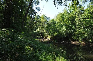
Scantic River State Park is a public recreation area consisting of several separated parcels totaling 784 acres (317 ha) along the Scantic River in the towns of Enfield, East Windsor, and Somers, Connecticut. The state park is suitable for hiking, fishing, and hunting and is managed by the Connecticut Department of Energy and Environmental Protection.

