Related Research Articles
In the U.S. state of New Jersey, the New Jersey Department of Transportation (NJDOT) maintains a system of state highways. Every significant section of roadway maintained by the state is assigned a number, officially State Highway Route X. Interstate Highways and U.S. Highways are included in the system. State Routes are signed with the circular highway shield.

A concurrency in a road network is an instance of one physical roadway bearing two or more different route numbers. When two roadways share the same right-of-way, it is sometimes called a common section or commons. Other terminology for a concurrency includes overlap, coincidence, duplex, triplex, multiplex, dual routing or triple routing.

Interstate 395 (I-395) is an auxiliary Interstate Highway in the U.S. states of Connecticut and Massachusetts; it is maintained by the Connecticut Department of Transportation (CTDOT) and the Massachusetts Department of Transportation (MassDOT). Spanning nearly 67 miles (108 km) on a south–north axis, it is the only spur route of I-95 in Connecticut. The 36-mile (58 km) section between its splits from I-95 in East Lyme and Connecticut Route 695 in Plainfield is a component highway of the Connecticut Turnpike. Within that state, the highway is named the American Ex-Prisoner of War Memorial Highway from Plainfield to Thompson.

The state highway system of the U.S. state of Oregon is a network of highways that are owned and maintained by the Highway Division of the Oregon Department of Transportation (ODOT).

Interstate 80 Business, called the Capital City Freeway in its entirety and also known as Business 80, is a business loop of Interstate 80 (I-80) through Sacramento, California, United States. The route is also colloquially referred to as "Cap City Freeway" and "Biz 80". The entire route is a freeway.
The New York State Department of Transportation (NYSDOT) is responsible for the establishment and classification of a state highway network which includes Interstate Highways, U.S. Highways, and state routes. U.S. and Interstate Highways are classified as state routes in New York; however, a letter is suffixed to the number of the route. As a result, there is apparent duplication between U.S. Routes, Interstate Highways and state routes.

An unsigned highway is a highway that has been assigned a route number, but does not bear road markings that would conventionally be used to identify the route with that number. Highways are left unsigned for a variety of reasons, and examples are found throughout the world. Depending on the policy of the agency that maintains the highway, and the reason for not signing the route, the route may instead be signed a different designation from its actual number, with small inventory markers for internal use, or with nothing at all.

In the U.S. state of Pennsylvania, state highways are generally maintained by the Pennsylvania Department of Transportation (PennDOT). Each is assigned a four-digit State Route (SR) number in the present Location Referencing System. Traffic Routes are signed as Interstate Highways, U.S. Routes and Pennsylvania Routes, and are prefixed with one to three zeroes to give a four-digit number. PA Routes are also called Pennsylvania Traffic Routes, and formerly State Highway Routes.
The Bradley Airport Connector is a 4.6-mile (7.4 km) expressway built to connect Bradley International Airport to Interstate 91 in Windsor, Connecticut. It begins at Exit 40 of I-91 and heads west following Route 20 for about 4 miles along the town line between Windsor and Windsor Locks. The expressway then turns north, leaving Route 20 and briefly becoming an unsigned state road ending at the airport terminals.

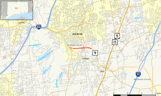
Route 220 is a 7.95-mile-long (12.79 km) state route in northern Connecticut and western Massachusetts, serving the southeastern suburbs of Springfield. The route runs in an "L" pattern and connects the town of Enfield, Connecticut, to the town of East Longmeadow. The route serves the Thompsonville and North Thompsonville sections of Enfield, connecting them to East Longmeadow center. In Connecticut, Route 220 is signed east-west. In Massachusetts, Route 220 is a town-maintained road and it is signed north-south.
The Willow Brook Connector is a 1.45-mile (2.33 km) unsigned expressway in the town of Berlin, Connecticut. The road is designated but not signed as State Road 571. It gets its name from Willow Brook Park, which begins on the north side of the roadway as one heads into the city of New Britain, or to New Britain Stadium for a baseball game.

The Arkansas Highway System is made up of all the highways designated as Interstates, U.S. Highways and State Highways in the US state of Arkansas. The system is maintained by the Arkansas Department of Transportation (ArDOT), known as the Arkansas State Highway Department (AHD) until 1977 and the Arkansas State Highway and Transportation Department (AHTD) from 1977 to 2017. The system contains 16,442.90 miles (26,462.28 km) of Interstates, U.S. Routes, state highways, and special routes. The shortest members are unsigned state highways Arkansas Highway 806 and Arkansas Highway 885, both 0.09 miles (0.14 km) in length. The longest route is U.S. Route 67, which runs 296.95 miles (477.89 km) from Texarkana to Missouri.
References
- ↑ "Connecticut State Numbered Routes and Roads" (PDF). Newington: Connecticut Department of Transportation. December 31, 2019. pp. 305–315. Retrieved July 14, 2020.