
New Haven is a coastal city in the U.S. state of Connecticut. It is located on New Haven Harbor on the northern shore of Long Island Sound in New Haven County, Connecticut, and is part of the New York City metropolitan area. With a population of 134,023 as determined by the 2020 United States Census, New Haven is now the third-largest city in Connecticut after Bridgeport and Stamford. New Haven is the principal municipality of Greater New Haven, which had a total population of 864,835 as of 2020.

Hamden is a town in New Haven County, Connecticut, United States. The town's nickname is "The Land of the Sleeping Giant". The population was 61,169 at the 2020 census.

Downtown New Haven is the neighborhood located in the heart of the city of New Haven, Connecticut. It is made up of the original nine squares laid out in 1638 to form New Haven, including the New Haven Green, and the immediate surrounding central business district, as well as a significant portion of the Yale University campus. The area includes many restaurants, cafes, theaters and stores. Downtown is bordered by Wooster Square to the east, Long Wharf to the southeast, the Hill neighborhood to the south, the Dwight neighborhood to the west, the Dixwell neighborhood to the northwest, the Prospect Hill area to the north, and East Rock to the northeast.
East Rock of south-central Connecticut, United States, with a high point of 366 feet (112 m), is a 1.4-mile (2 km) long trap rock ridge located primarily in the neighborhood of East Rock on the north side of the city of New Haven. A prominent landscape feature and a popular outdoor recreation area with cliffs that rise 300 feet (91 m) over the city below, East Rock is part of the narrow, linear Metacomet Ridge that extends from Long Island Sound near New Haven, north through the Connecticut River Valley of Massachusetts to the Vermont border. East Rock is the central feature of East Rock Park, a municipal park owned by the city of New Haven along the New Haven-Hamden town line.

Fair Haven is a neighborhood in the eastern part of the city of New Haven, Connecticut, between the Mill and Quinnipiac rivers. The northeast section of the neighborhood is also known as Chatham Square.

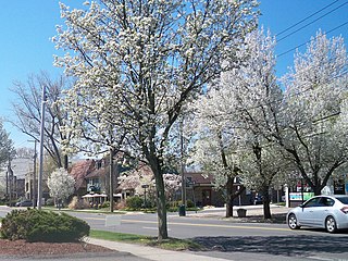
Westville is a neighborhood of the city of New Haven, Connecticut. The area is positively reviewed for its walkability, diverse population, and livability. It is more expensive than the average American city, has lower crime rates, and graduates children from high school at rates above the national average.
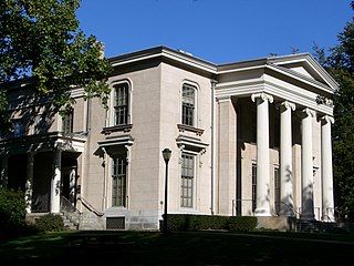
Hillhouse Avenue is a street in New Haven, Connecticut, famous for its many nineteenth century mansions, including the president's house at Yale University. Both Charles Dickens and Mark Twain have described it as "the most beautiful street in America." Much of the avenue is included in the Hillhouse Avenue Historic District, which extends to include houses on adjacent streets.

Cedar Hill is a neighborhood in New Haven, Connecticut. It includes portions of the city-designated neighborhoods of East Rock, Quinnipiac Meadows, and Mill River. Cedar Hill was named for cedar trees that were once plentiful there in 1665. The area was divided from the local surroundings by the construction of I-91 in the 1960s. Cedar Hill's boundary runs from James Street, up the Mill River, to Rice Field, over Indian Head Rock, to the Hamden town line, across to Middletown Avenue, to the Eastern side of State Street, back up to James Street.

The Wooster Square Historic District encompasses much of the Wooster Square neighborhood of New Haven, Connecticut. Centered on a rectangular park named in honor of General David Wooster, the area was developed as a residential neighborhood beginning in the 1820s, and was by the 1840s a desirable area to live, with many high-quality Greek Revival homes. In the 1950s the area was the subject of a major community-led preservation effort that drew national attention. The district was listed on the National Register of Historic Places in 1971.
East Rock Park is a park in the city of New Haven and the town of Hamden, Connecticut that is operated as a New Haven city park. The park surrounds and includes the mountainous ridge named East Rock and was developed with naturalistic landscaping. The entire 427-acre (173 ha) park is listed on the National Register of Historic Places.

Whitneyville is a neighborhood in the southeastern portion of the town of Hamden, Connecticut. It started in the early nineteenth century as a factory town for workers in Eli Whitney's gun factory. Around the turn of the twentieth century, it evolved into a trolley suburb of New Haven. Today it is primarily residential, with a mixture of single-family homes and small apartment and condominium buildings. There is some commercial development centered around the intersection of Whitney and Putnam avenues.
Dixwell is a neighborhood of New Haven, Connecticut. Named for Dixwell Avenue, the main thoroughfare of the neighborhood which in turn was named for regicide judge John Dixwell, it is situated generally northwest of and adjacent to Downtown New Haven.

Prospect Hill is a neighborhood of the city of New Haven, Connecticut located in the north central portion of the city, directly north of Downtown New Haven. The neighborhood contains residences, institutional buildings of Albertus Magnus University and a portion of the main campus of Yale University, including the Science Hill area, the Hillhouse Avenue area and the Yale Peabody Museum. The City of New Haven defines the neighborhood to be the region bounded by the town of Hamden in the north, Winchester Avenue in the west, Munson Street/Hillside Place/Prospect Street in the southwest, Trumbull Street in the south, and Whitney Avenue in the east. Prospect Street is the main thoroughfare through the neighborhood.
The Prospect Hill Historic District is an irregularly-shaped 185-acre (75 ha) historic district in New Haven, Connecticut. The district encompasses most of the residential portion of the Prospect Hill neighborhood.

The Whitney Avenue Historic District is a historic district in the East Rock neighborhood of New Haven, Connecticut. It is a 203-acre (82 ha) district which included 1,084 contributing buildings when it was listed on the National Register of Historic Places in 1989.
The city of New Haven, Connecticut has many distinct neighborhoods. In addition to Downtown, centered on the central business district and the Green, are the following neighborhoods: the west central neighborhoods of Dixwell and Dwight; the southern neighborhoods of The Hill, historic water-front City Point, and the harborside district of Long Wharf; the western neighborhoods of Edgewood, West River, Westville, Amity, and West Rock; East Rock, Cedar Hill, Prospect Hill, and Newhallville in the northern side of town; the east central neighborhoods of Mill River and Wooster Square, an Italian-American neighborhood; Fair Haven, an immigrant community located between the Mill and Quinnipiac rivers; Quinnipiac Meadows and Fair Haven Heights across the Quinnipiac River; and facing the eastern side of the harbor, The Annex and East Shore.
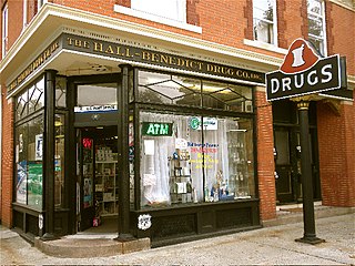
The Hall-Benedict Drug Company Building is a historic commercial building at 763-767 Orange Street in the East Rock neighborhood of New Haven, Connecticut. Built in 1909 to house a pharmacy, it is a little-altered and well-preserved example of an early 20th-century mixed residential-commercial neighborhood building. The building was listed on the National Register in 1986. It is also a contributing property in the Whitney Avenue Historic District.

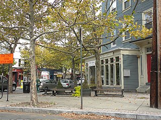
The Orange Street Historic District encompasses a large residential in the East Rock section of New Haven, Connecticut. Roughly bounded by Orange, Cottage, Eagle, State, and Audubon Streets, this area saw growth between about 1830 and 1900, and includes a broad diversity of well-preserved 19th-century residential structures. It was listed on the U.S. National Register of Historic Places in 1985. At that time, it included 546 buildings deemed to contribute to the historic character of the area.
The Upper State Street Historic District encompasses a well-preserved neighborhood commercial district of the late 19th century in the East Rock neighborhood of New Haven, Connecticut. The district is an irregular strip running NNE to SSW mainly along State Street in New Haven, one block west of Interstate 91, the highway which determines the district's eastern and southern borders. The district was listed on the U.S. National Register of Historic Places in 1984.
Spring Glen is a neighborhood in the southeastern portion of the town of Hamden, Connecticut. It is primarily residential, mostly single-family homes with a few two-family. Commercial development is entirely on its principal street, Whitney Avenue. It was developed throughout the first half of the twentieth century as a trolley suburb of New Haven. It was named for the Spring Glen dairy farm established by James J. Webb in 1858 in what would become part of the neighborhood.


