Ekwok, Alaska

Last updated

Ekwok, Alaska
Iquaq
USA Alaska location map.svg
Red pog.svg
Ekwok
Location in Alaska
Coordinates: 59°20′57″N157°29′7″W / 59.34917°N 157.48528°W / 59.34917; -157.48528
CountryUnited States
State Alaska
Census Area Dillingham
Incorporated 1974 [1]
Government
   Mayor Luki Akelkok, Sr. [2]
   State senator Lyman Hoffman (D)
   State rep. Bryce Edgmon (I)
Area
[3]
  Total18.01 sq mi (46.64 km2)
  Land16.75 sq mi (43.37 km2)
  Water1.26 sq mi (3.27 km2)
Elevation
98 ft (30 m)
Population
 (2020)
  Total111
  Density6.63/sq mi (2.56/km2)
Time zone UTC-9 (Alaska (AKST))
  Summer (DST) UTC-8 (AKDT)
ZIP codes
99580
Area code 907
FIPS code 02-21810
GNIS feature ID 1401738

Ekwok (Central Yupik : Iquaq) is a city in Dillingham Census Area, Alaska, United States. At the 2020 census, the population was 111.

Contents

History

Ekwok means "end of the bluff" (river's edge) in Yupik, [4] [5] from iquk ("end"). [6] It is the oldest continuously occupied Yupik village on the Nushagak River. During the 1800s, the settlement was used in the spring and summer as a fish camp, and in the fall as a base camp for picking berries. By 1923, it was the largest settlement along the river.

From the early 1900s until 1941, mail was delivered by dog sled from Dillingham. In 1941 a post office opened in Ekwok. Before 1960, most of the buildings in Ekwok were located in a low area near the river. After a flood in the early 1960s, the village was relocated to its current location.

Geography

Ekwok is located at 59°20′57″N157°29′7″W / 59.34917°N 157.48528°W / 59.34917; -157.48528 (59.349260, -157.485404). [7]

Ekwok is on the Nushagak River in southwestern Alaska, 43 miles (69 km) northeast of Dillingham.

According to the United States Census Bureau, Ekwok has a total area of 17.5 square miles (45.4 km2), of which 16.3 square miles (42.1 km2) is land and 1.2 square miles (3.2 km2), or 7.10%, is water. [8]

Demographics

Historical population
CensusPop.Note
1930 40
1940 6870.0%
1950 13192.6%
1960 106−19.1%
1970 103−2.8%
1980 77−25.2%
1990 770.0%
2000 13068.8%
2010 115−11.5%
2020 111−3.5%
U.S. Decennial Census [9]

Ekwok first appeared on the 1930 U.S. Census as "Ekwak", an unincorporated village, and again in 1940. The name (or spelling) was changed to Ekwok with the 1950 U.S. Census. It was formally incorporated in 1974.

As of the census [10] of 2000, there were 130 people, 42 households, and 29 families residing in the city. The population density was 8.1 inhabitants per square mile (3.1/km2). There were 56 housing units at an average density of 3.5 per square mile (1.4/km2). The racial makeup of the city was 6.15% White, 91.54% Native American, and 2.31% from two or more races.

There were 42 households, out of which 47.6% had children under the age of 18 living with them, 61.9% were married couples living together, 7.1% had a female householder with no husband present, and 28.6% were non-families. 28.6% of all households were made up of individuals, and 4.8% had someone living alone who was 65 years of age or older. The average household size was 3.10 and the average family size was 3.93.

In the city, the age distribution of the population shows 43.8% under the age of 18, 3.8% from 18 to 24, 26.2% from 25 to 44, 19.2% from 45 to 64, and 6.9% who were 65 years of age or older. The median age was 32 years. For every 100 females, there were 113.1 males. For every 100 females age 18 and over, there were 114.7 males.

The median income for a household in the city was $16,250, and the median income for a family was $20,000. Males had a median income of $38,750 versus $35,750 for females. The per capita income for the city was $11,079. There were 29.2% of families and 32.1% of the population living below the poverty line, including 24.4% of under eighteens and 40.0% of those over 64.

Education

The William "Sonny" Nelson School of the Southwest Region School District serves the village. [11]

Related Research Articles

<span class="mw-page-title-main">Dillingham Census Area, Alaska</span> Census area in Alaska, United States

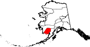
Dillingham Census Area is a census area located in the state of Alaska, United States. At the 2020 census, the population was 4,857, slightly up from 4,847 in 2010. It is part of the unorganized borough and therefore has no borough seat. Its largest community by far is the city of Dillingham, on a small arm of Bristol Bay on the Bering Sea.

<span class="mw-page-title-main">Goodnews Bay, Alaska</span> City in Alaska, United States

Goodnews Bay is a city in Bethel Census Area, Alaska, United States. As of the 2010 census, the population of the city was 243, up from 230 in 2000.

<span class="mw-page-title-main">Kwethluk, Alaska</span> City in Alaska, United States

Kwethluk is a city in Bethel Census Area in the U.S. state of Alaska. At the 2010 census the population was 721, up from 713 in 2000. It is the birthplace of Saint Olga of Alaska

<span class="mw-page-title-main">Napaskiak, Alaska</span> City in Alaska, United States

Napaskiak is a city in Bethel Census Area, Alaska, United States. At the 2010 census the population was 405, up from 390 in 2000.

<span class="mw-page-title-main">Platinum, Alaska</span> City in Alaska, United States

Platinum is a city in Bethel Census Area, Alaska, United States. The population was 61 at the 2010 census, up from 41 in 2000.

<span class="mw-page-title-main">South Naknek, Alaska</span> CDP in Alaska, United States

South Naknek is a census-designated place (CDP) in Bristol Bay Borough, Alaska, United States. At the 2020 census the population was 67, down from 79 in 2010.

<span class="mw-page-title-main">Aleknagik, Alaska</span> City in Alaska, United States

Aleknagik is a second class city in the Dillingham Census Area of the Unorganized Borough of the U.S. state of Alaska. The population was 219 at the 2010 census, down from 221 in 2000.

<span class="mw-page-title-main">Dillingham, Alaska</span> Town in Alaska

Dillingham, also known as Curyung, is a city in Dillingham Census Area, Alaska, United States. Incorporated in 1963, it is an important commercial fishing port on Nushagak Bay. As of the 2020 census, the population of the city was 2,249, down from 2,329 in 2010.

<span class="mw-page-title-main">Koliganek, Alaska</span> Census-designated place in Alaska, United States

Koliganek is a census-designated place (CDP) in Dillingham Census Area, Alaska, United States. It is located along the Nushagak River At the 2010 census, the population was 209, up from 182 in 2000.

<span class="mw-page-title-main">New Stuyahok, Alaska</span> City in Alaska, United States

New Stuyahok is a city in Dillingham Census Area, Alaska, United States. At the 2010 census the population was 510, up from 471 in 2000.

<span class="mw-page-title-main">Portage Creek, Alaska</span> Census-designated place in Alaska, United States

Portage Creek is a census-designated place (CDP) in Dillingham Census Area, Alaska, United States. The population was 2 at the 2010 census, down from 36 at the 2000 census.

Togiak is a city in Dillingham Census Area, Alaska, United States. At the 2010 census the population was 817, up from 809 in 2000.

<span class="mw-page-title-main">Egegik, Alaska</span> City in Alaska, United States

Egegik is a city in Lake and Peninsula Borough, Alaska, United States. As of the 2020 census, the population of the city is 39, down from 109 in 2010. It has been home to cannery operations. If the city's population somehow exploded in the decades to come, it will potentially become the new borough seat of Lake and Peninsula Borough replacing King Salmon.

<span class="mw-page-title-main">Igiugig, Alaska</span> Census-designated place in Alaska, United States

Igiugig is a census-designated place (CDP) in Lake and Peninsula Borough, Alaska, United States. The population was 68 at the 2020 census, up from 54 in 2010. The village is at the source of the Kvichak River, at the outlet of Lake Iliamna.

Newhalen is a city in Lake and Peninsula Borough, Alaska, United States. At the 2020 census, the population was 168.

St. Michael, historically referred to as Saint Michael, is a city in Nome Census Area, Alaska. The population was 401 at the 2010 census, up from 368 in 2000.

Stebbins is a city in Nome Census Area, Alaska, United States. At the 2010 census the population was 556, up from 547 in 2000.

Kotlik is a city in Kusilvak Census Area, Alaska, United States. At the 2010 census the population was 577, down from 591 in 2000.

Nunam Iqua, formerly called Sheldon Point, is a city in the Kusilvak Census Area in the U.S. state of Alaska. At the 2010 census the population was 187, up from 164 in 2000.

St. Mary's is a city in Kusilvak Census Area, Alaska, United States. The adjacent village of Andreafsky joined with St. Mary's in 1980. At the 2010 census the population was 507, up from 500 in 2000. By 2018, the population was estimated to be 567.

References

  1. 1996 Alaska Municipal Officials Directory. Juneau: Alaska Municipal League/Alaska Department of Community and Regional Affairs. January 1996. p. 52.
  2. 2015 Alaska Municipal Officials Directory. Juneau: Alaska Municipal League. 2015. p. 58.
  3. "2020 U.S. Gazetteer Files". United States Census Bureau. Retrieved October 29, 2021.
  4. Sandy Nestor (2003). Indian Placenames in America. McFarland. p. 11. ISBN   978-0-7864-1654-7. In Yup'ik Eskimo, the name is translated as "end of the bluff."
  5. Travel Holiday. Travel Magazine. 1985. p. 796. the word Ekwok means river's edge
  6. William Bright (2004). Native American Placenames of the United States. University of Oklahoma Press. p. 142. ISBN   978-0-8061-3598-4. From Yupik (Eskimo) iquaq, based on iquk 'end' (Jacobson 1984).
  7. "US Gazetteer files: 2010, 2000, and 1990". United States Census Bureau. February 12, 2011. Retrieved April 23, 2011.
  8. "Geographic Identifiers: 2010 Demographic Profile Data (G001): Ekwok city, Alaska". U.S. Census Bureau, American Factfinder. Retrieved October 8, 2015.[ dead link ]
  9. "Census of Population and Housing". Census.gov. Retrieved June 4, 2015.
  10. "U.S. Census website". United States Census Bureau . Retrieved January 31, 2008.
  11. "Ekwok Archived 2018-10-30 at the Wayback Machine ." Southwest Region School District. Retrieved on March 26, 2017.

59°20′57″N157°29′07″W / 59.34926°N 157.485404°W / 59.34926; -157.485404