Manokotak, Alaska

Last updated

Manokotak
Manuquutaq
USA Alaska location map.svg
Red pog.svg
Manokotak
Location in Alaska
Coordinates: 58°58′52″N159°3′21″W / 58.98111°N 159.05583°W / 58.98111; -159.05583
CountryUnited States
State Alaska
Census Area Dillingham
Incorporated October 19, 1970 [1]
Government
   Mayor Melvin Andrew [2]
   State senator Lyman Hoffman (D)
   State rep. Bryce Edgmon (I)
Area
[3]
  Total108.45 sq mi (280.87 km2)
  Land73.14 sq mi (189.43 km2)
  Water35.31 sq mi (91.45 km2)
Elevation
16 ft (5 m)
Population
  Total488
  Density6.67/sq mi (2.58/km2)
Time zone UTC-9 (Alaska (AKST))
  Summer (DST) UTC-8 (AKDT)
ZIP code
99628
Area code 907
FIPS code 02-46890
GNIS feature ID 1405927

Manokotak (Central Yupik : Manuquutaq) is a city in Dillingham Census Area, Alaska, United States. At the 2010 census the population was 442, [4] up from 399 in 2000.

Contents

Geography

Manokotak is located at 58°58′52″N159°3′21″W / 58.98111°N 159.05583°W / 58.98111; -159.05583 (58.981087, -159.055808). [5]

According to the United States Census Bureau, the city has a total area of 37.1 square miles (96.2 km2), of which 35.8 square miles (92.6 km2) is land and 1.4 square miles (3.6 km2), or 3.79%, is water. [4]

Demographics

Historical population
CensusPop.Note
1950 120
1960 14924.2%
1970 21443.6%
1980 29437.4%
1990 38531.0%
2000 3993.6%
2010 442 [4] 10.8%
2020 488[ citation needed ]10.4%
U.S. Decennial Census [6] [ failed verification ]

Manokotak first appeared on the 1950 U.S. Census as an unincorporated village. It formally incorporated in 1970.

As of the Census' 2018 American Community Survey, there were 824 people and 152 households residing in the village. The population density was 11.3 people per square mile. There were 249 housing units with a median value of $70,000 per housing unit. The racial makeup of the city was about 70% native, 16% white, and 4% Asian. [7]

There were 93 households, out of which 55.9% had children under the age of 18 living with them, 67.7% were married couples living together, 11.8% had a female householder with no husband present, and 17.2% were non-families. 15.1% of all households were made up of individuals, and none had someone living alone who was 65 years of age or older. The average household size was 4.29 and the average family size was 4.92.

In the village the age distribution of the population shows 44.4% under the age of 18, 10.8% from 18 to 24, 24.8% from 25 to 44, 15.0% from 45 to 64, and 5.0% who were 65 years of age or older. The median age was 22 years. For every 100 females, there were 116.8 males. For every 100 females age 18 and over, there were 133.7 males.

The median income for a household in the village was $26,875, and the median income for a family was $30,357. Males had a median income of $13,125 versus $0 for females. The per capita income for the city was $9,294. About 32.5% of families and 35.3% of the population were below the poverty line, including 44.0% of those under age 18 and none of those age 65 or over.

Notable people

Education

The Manokotak "Nunaniq" School of the Southwest Region School District serves the village. [12]

Health

Sale, importation and possession of alcohol are banned in the village. [13]

Related Research Articles

<span class="mw-page-title-main">Chuathbaluk, Alaska</span> City in Alaska, United States

Chuathbaluk is a city in Bethel Census Area, Alaska, United States.

Upper Kalskag is a city in Bethel Census Area, Alaska, United States. It is thirty miles west of Aniak. At the 2010 census the population was 210, down from 230 in 2000.

Clark's Point is a city in Dillingham Census Area, Alaska, United States. The population was 62 at the 2010 census.

Ekwok is a city in Dillingham Census Area, Alaska, United States. At the 2020 census, the population was 111.

Larsen Bay is a city in Kodiak Island Borough, Alaska, United States. At the 2010 census the population was 87, down from 115 in 2000.

<span class="mw-page-title-main">Chignik, Alaska</span> City in Alaska, United States

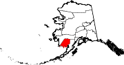
Chignik is a city in Lake and Peninsula Borough, Alaska, United States. It is two hundred and fifty miles southwest of Kodiak. At the 2020 census the population was 97, up from 91 in 2010.

<span class="mw-page-title-main">Egegik, Alaska</span> City in Alaska, United States

Egegik is a city in Lake and Peninsula Borough, Alaska, United States. As of the 2020 census, the population of the city is 39, down from 109 in 2010. It has been home to cannery operations. If the city's population somehow exploded in the decades to come, it will potentially become the new borough seat of Lake and Peninsula Borough replacing King Salmon.

<span class="mw-page-title-main">Ivanof Bay, Alaska</span> Census-designated place in Alaska, United States

Ivanof Bay is a census-designated place (CDP) in Lake and Peninsula Borough, Alaska, United States. The population was just one at the 2020 census, down from seven in 2010.

<span class="mw-page-title-main">Pilot Point, Alaska</span> City in Alaska, United States

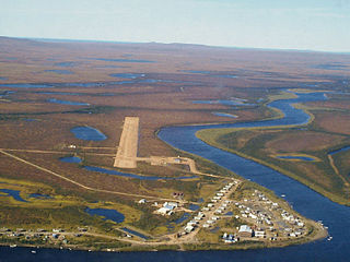
Pilot Point is a city in Lake and Peninsula Borough, Alaska, United States, on the Alaska Peninsula. As of the 2020 census, the population of the city was 70, up from 68 in 2010.

<span class="mw-page-title-main">Port Alsworth, Alaska</span> Census-designated place in Alaska, United States

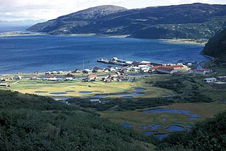
Port Alsworth is a census-designated place (CDP) in Lake and Peninsula Borough, Alaska, United States. It is 165 miles (266 km) by air southwest of Anchorage. The population was 186 at the 2020 census, up from 159 in 2010. It is the most populated community in the borough.

Koyuk is a city in the Nome Census Area, Alaska, United States. The population was 332 at the 2010 census, up from 297 in 2000.

St. Michael, historically referred to as Saint Michael, is a city in Nome Census Area, Alaska. The population was 401 at the 2010 census, up from 368 in 2000.

<span class="mw-page-title-main">Buckland, Alaska</span> City in Alaska, United States

Buckland is a city in Northwest Arctic Borough, Alaska, United States. At the 2010 census the population was 416, up from 406 in 2000. It takes its English name from the Buckland River, which in turn takes its name from Oxford University professor William Buckland.

<span class="mw-page-title-main">Kobuk, Alaska</span> City in Alaska, United States

Kobuk is a city in Northwest Arctic Borough, Alaska, United States. At the 2010 census the population was 151, up from 109 in 2000.

St. Mary's is a city in Kusilvak Census Area, Alaska, United States. The adjacent village of Andreafsky joined with St. Mary's in 1980. At the 2010 census the population was 507, up from 500 in 2000. By 2018, the population was estimated to be 567.

<span class="mw-page-title-main">Holy Cross, Alaska</span> City in Alaska

Holy Cross is a city in Yukon-Koyukuk Census Area, Alaska, United States. At the 2010 census the population was 178, down from 227 in 2000.

<span class="mw-page-title-main">Huslia, Alaska</span> City in Alaska, United States

Huslia is a city in Yukon-Koyukuk Census Area, Alaska, United States. Rarely known as Hussliakatna, it is inhabited by Koyukuk-hotana Athabascans. The population was 293 at the 2000 census and 275 as of the 2010 census.

Shageluk is a city in Yukon-Koyukuk Census Area, Alaska, United States. At the 2010 census the population was 83, down from 129 in 2000.

<span class="mw-page-title-main">Plaucheville, Louisiana</span> Village in Louisiana, United States

Plaucheville is a village in Avoyelles Parish, Louisiana, United States. The population was 248 at the 2010 census.

<span class="mw-page-title-main">Lake Roesiger, Washington</span> CDP in Washington, United States

Lake Roesiger is a census-designated place (CDP) in Snohomish County, Washington, United States. The population was 503 at the 2010 census.

References

  1. 1996 Alaska Municipal Officials Directory. Juneau: Alaska Municipal League/Alaska Department of Community and Regional Affairs. January 1996. p. 93.
  2. 2015 Alaska Municipal Officials Directory. Juneau: Alaska Municipal League. 2015. p. 99.
  3. "2020 U.S. Gazetteer Files". United States Census Bureau. Retrieved October 29, 2021.
  4. 1 2 3 "Geographic Identifiers: 2010 Demographic Profile Data (G001): Manokotak city, Alaska". U.S. Census Bureau, American Factfinder. Retrieved October 9, 2015.[ dead link ]
  5. "US Gazetteer files: 2010, 2000, and 1990". United States Census Bureau. February 12, 2011. Retrieved April 23, 2011.
  6. "Census of Population and Housing". Census.gov. Retrieved June 4, 2015.
  7. "Census profile: Manokotak, AK". Census Reporter. Retrieved August 10, 2020.
  8. "Dick gets 99 years for murder of VPSO".
  9. "Killed VPSO officer in Manokotak mourned as irreplaceable". Anchorage Daily News.
  10. "Governor Signs Edgmon Bill to Allow Arming of VPSOs". housemajority.org. July 18, 2014. Archived from the original on December 30, 2016. Retrieved June 19, 2023.
  11. "Don Page wins prestigious U of a research award".
  12. "Manokotak." Southwest Region School District. Retrieved on March 26, 2017.
  13. "Schedule of Local Option Communities" (PDF). Alcoholic Beverage Control Board. Retrieved May 3, 2023.

58°58′52″N159°03′21″W / 58.981087°N 159.055808°W / 58.981087; -159.055808