Portage Creek, Alaska

Last updated

Portage Creek, Alaska
AKMap-doton-Dillingham.PNG
Location of Portage Creek, Alaska
Coordinates: 58°54′22″N157°43′0″W / 58.90611°N 157.71667°W / 58.90611; -157.71667
CountryUnited States
State Alaska
Census Area Dillingham
Government
   State senator Lyman Hoffman (D)
   State rep. Bryce Edgmon (I)
Area
[1]
  Total13.17 sq mi (34.11 km2)
  Land13.17 sq mi (34.11 km2)
  Water0.00 sq mi (0.00 km2)
Elevation
40 ft (10 m)
Population
 (2020)
  Total4
  Density0.30/sq mi (0.12/km2)
Time zone UTC-9 (Alaska (AKST))
  Summer (DST) UTC-8 (AKDT)
ZIP code
99569 [2]
Area code 907
FIPS code 02-62285

Portage Creek is a census-designated place (CDP) in Dillingham Census Area, Alaska, United States. The population was 2 at the 2010 census, [3] down from 36 at the 2000 census.

Contents

Geography

The Portage Creek CDP is located at 58°54′22″N157°43′0″W / 58.90611°N 157.71667°W / 58.90611; -157.71667 (58.906088, -157.716758), [4] at the confluence of Portage Creek with the Nushagak River.

According to the United States Census Bureau, the CDP has a total area of 12.9 square miles (33.3 km2), all of it land. [3]

Demographics

Historical population
CensusPop.Note
1980 48
1990 5−89.6%
2000 36620.0%
2010 2−94.4%
2020 4100.0%
U.S. Decennial Census [5]

Portage Creek first appeared on the 1980 U.S. Census as a census-designated place (CDP). In 1990, it lost that designation and was reclassified as an unincorporated Alaskan Native Village Statistical Area (ANVSA). In 2000, it regained its status as a census-designated place (CDP).

As of the census [6] of 2000, there were 36 people, 7 households, and 4 families residing in the CDP. The population density was 2.7 people per square mile (1.0 people/km2). There were 22 housing units at an average density of 1.7 per square mile (0.66/km2). The racial makeup of the CDP was 13.89% White and 86.11% Native American.

There were 7 households, out of which 57.1% had children under the age of 18 living with them, 71.4% were married couples living together, and 28.6% were non-families. 28.6% of all households were made up of individuals, and none had someone living alone who was 65 years of age or older. The average household size was 5.14 and the average family size was 6.60.

In the CDP, the population was spread out, with 52.8% under the age of 18, 11.1% from 18 to 24, 25.0% from 25 to 44, 5.6% from 45 to 64, and 5.6% who were 65 years of age or older. The median age was 14 years. For every 100 females, there were 111.8 males. For every 100 females age 18 and over, there were 88.9 males.

The median income for a household in the CDP was $41,250, and the median income for a family was $41,250. Males had a median income of $0 versus $16,250 for females. The per capita income for the CDP was $8,010. There were no families and none of the population living below the poverty line, including no under eighteens and none of those over 64.

As of November 2013 there were only 2 year-round residents of Portage Creek. [7]

Education

It was previously served by the Portage Creek School, operated by the Southwest Region School District. [8] [9]

Related Research Articles

<span class="mw-page-title-main">South Naknek, Alaska</span> CDP in Alaska, United States

South Naknek is a census-designated place (CDP) in Bristol Bay Borough, Alaska, United States. At the 2020 census the population was 67, down from 79 in 2010.

Covenant Life is a census-designated place (CDP) in Haines Borough, Alaska, United States. At the 2020 census the population was 25, down from 86 at the 2010 census.

<span class="mw-page-title-main">Bear Creek, Alaska</span> Census-designated place in Alaska, United States

Bear Creek is a census-designated place (CDP) in Kenai Peninsula Borough, Alaska, United States. At the 2020 census the population was 2,129 up from 1,956 in 2010. Bear Creek is a few miles north of Seward near the stream of the same name and its source, Bear Lake.

<span class="mw-page-title-main">Crown Point, Alaska</span> Census-designated place in Alaska, United States

Crown Point is a census-designated place (CDP) in Kenai Peninsula Borough, Alaska, United States. The population was 74 at the 2010 census. Land access to this area is by either the Alaska Railroad or the Seward Highway.

<span class="mw-page-title-main">Primrose, Alaska</span> Census-designated place in Alaska, United States

Primrose is a census-designated place (CDP) in Kenai Peninsula Borough, Alaska, United States. The population was 78 at the 2010 census, down from 93 at the 2000 census. Primrose is one of a number of small communities located north of Seward along the Seward Highway.

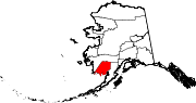
Aleneva is a census-designated place in the Kodiak Island Borough in the U.S. state of Alaska. As of the 2010 census, the population was 37, down from 68 in 2000.

Womens Bay is a census-designated place (CDP) in Kodiak Island Borough, Alaska, United States. At the 2020 census the population was 743, up from 719 in 2010. The name is correctly spelled "Womens", without an apostrophe.

<span class="mw-page-title-main">Pilot Point, Alaska</span> City in Alaska, United States

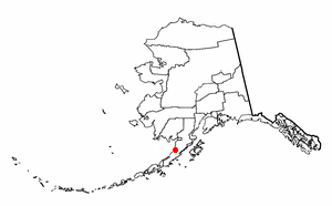
Pilot Point is a city in Lake and Peninsula Borough, Alaska, United States, on the Alaska Peninsula. As of the 2020 census, the population of the city was 70, up from 68 in 2010.

<span class="mw-page-title-main">Ugashik, Alaska</span> Census-designated place in Alaska, United States

Ugashik is a census-designated place (CDP) in Lake and Peninsula Borough, Alaska, United States. The population was 4 at the 2020 census, down from 12 in 2010.

<span class="mw-page-title-main">Petersville, Alaska</span> Census-designated place in Alaska, United States

Petersville is a census-designated place (CDP) in Matanuska-Susitna Borough, Alaska, United States. It is part of the Anchorage Metropolitan Area. The population was 27 at the 2020 census.

<span class="mw-page-title-main">Game Creek, Alaska</span> Census-designated place in Alaska, United States

Game Creek is a census-designated place (CDP) on Chichagof Island in Hoonah-Angoon Census Area, Alaska, United States. The population was 18 at the 2010 census, down from 35 at the 2000 census.

<span class="mw-page-title-main">Whitestone Logging Camp, Alaska</span> Census-designated place in Alaska, United States

Whitestone Logging Camp is a census-designated place (CDP) on Chichagof Island in Hoonah-Angoon Census Area, Alaska, United States. In 2010, the population was 17, down from 116 in 2000. It is not to be confused with Whitestone, another CDP in Southeast Fairbanks Census Area.

<span class="mw-page-title-main">Alcan Border, Alaska</span> Census-designated place in Alaska, United States

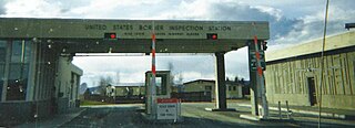
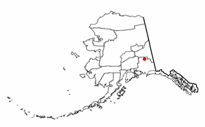
Alcan Border, also known as Port Alcan, is a census-designated place in the Southeast Fairbanks Census Area in the U.S. state of Alaska. Part of the Unorganized Borough, Alcan Border is the site of the Alcan - Beaver Creek Border Crossing, the main U.S. port of entry for persons arriving in Alaska by road. The population was 33 at the 2010 census, up from 21 in 2000.

<span class="mw-page-title-main">Chistochina, Alaska</span> CDP in Alaska, United States

Chistochina is a census-designated place (CDP) in Copper River Census Area, Alaska, United States. At the 2020 census the population was 60, down from 93 in 2010.

Nelchina is a census-designated place (CDP) in Copper River Census Area, Alaska, United States. The population was 45 at the 2020 census, down from 59 in 2010.

Willow Creek is a census-designated place (CDP) in Copper River Census Area, Alaska, United States. At the 2020 census the population was 190, down from 191 in 2010.

Birch Creek is a census-designated place (CDP) in Yukon-Koyukuk Census Area, Alaska, United States. The population was 33 at the 2010 census, up from 28 in 2000.

<span class="mw-page-title-main">Central, Alaska</span> CDP in Alaska, United States

Central is a census-designated place (CDP) in Yukon-Koyukuk Census Area, Alaska, United States. At the 2010 census the population was 96, down from 134 in 2000. Every February, Central hosts a checkpoint for the long-distance Yukon Quest sled dog race.

<span class="mw-page-title-main">Chalkyitsik, Alaska</span> CDP in Alaska, United States

Chalkyitsik, meaning "to fish with a hook, at the mouth of the creek", is a census-designated place (CDP) in Yukon-Koyukuk Census Area, Alaska, United States. It is located on the left (south) bank of the Black River, 45 miles northeast of Fort Yukon. At the 2010 census the population was 69, down from 83 in 2000.

<span class="mw-page-title-main">Rockland, La Crosse County, Wisconsin</span> Village in Wisconsin, United States

Rockland is a village in eastern La Crosse County, Wisconsin, United States, along the La Crosse River. It is part of the La Crosse, Wisconsin Metropolitan Statistical Area. The population was 765 at the 2020 census.

References

  1. "2020 U.S. Gazetteer Files". United States Census Bureau. Retrieved October 29, 2021.
  2. "Portage Creek AK ZIP Code". zipdatamaps.com. 2023. Retrieved June 16, 2023.
  3. 1 2 "Geographic Identifiers: 2010 Demographic Profile Data (G001): Portage Creek CDP, Alaska". U.S. Census Bureau, American Factfinder. Retrieved October 9, 2015.[ dead link ]
  4. "US Gazetteer files: 2010, 2000, and 1990". United States Census Bureau. February 12, 2011. Retrieved April 23, 2011.
  5. "U.S. Decennial Census". Census.gov. Retrieved June 6, 2013.
  6. "U.S. Census website". United States Census Bureau . Retrieved January 31, 2008.
  7. Alaska Public Radio Networks' "300 Villages" project
  8. "Map of the Alaska School Districts (2013)." Alaska Department of Education. Retrieved on March 12, 2017.
  9. "Portage Creek School." Alaska Department of Education. Retrieved on March 26, 2017.

58°54′22″N157°43′00″W / 58.906088°N 157.716758°W / 58.906088; -157.716758