Elkview, West Virginia

Last updated

Elkview, West Virginia
Kanawha County West Virginia incorporated and unincorporated areas Elkview highlighted.svg
Location in Kanawha County and state of West Virginia.
Coordinates: 38°26′16″N81°28′55″W / 38.43778°N 81.48194°W / 38.43778; -81.48194
Country United States
State West Virginia
County Kanawha
Area
  Total1.8 sq mi (4.6 km2)
  Land1.7 sq mi (4.4 km2)
  Water0.1 sq mi (0.2 km2)
Elevation
604 ft (184 m)
Population
 (2010) [1]
  Total1,222
  Density680/sq mi (270/km2)
Time zone UTC-5 (Eastern (EST))
  Summer (DST) UTC-4 (EDT)
ZIP code
25071
Area code 304
FIPS code 54-24748 [2]
GNIS feature ID1554387 [3]

Elkview is a census-designated place (CDP) in Kanawha County, West Virginia, United States. The population was 1,222 at the 2010 census. [1] It is named after the Elk River, which flows into the Kanawha River.

Contents

Interstate 79, the "Jennings Randolph Expressway", provides highway access to Elkview from exit 9. U.S. Route 119 also reaches Elkview. A shopping center was built off I-79, which includes a La Quinta Inns and Suites, Kroger,and several fast food restaurants. Hundreds of people were stranded at this shopping center during the 2016 West Virginia flood, as the bridge leading to it from the interstate was washed away. [4]

This small town is nestled between the larger town of Clendenin, and the municipality of Kanawha County, Charleston.

Geography

Elkview is located at 38°26′16″N81°28′55″W / 38.43778°N 81.48194°W / 38.43778; -81.48194 (38.437810, -81.482007), [5] twelve miles east of Charleston.

According to the United States Census Bureau, the Elkview CDP has a total area of 1.8 square miles (4.6 km2), of which 1.7 square miles (4.4 km2) is land and 0.1 square mile (0.2 km2) (4.49%) is water.

Demographics

As of the census [2] of 2000, there were 1,182 people, 507 households, and 370 families residing in the community. The population density was 697.4 people per square mile (270.0/km2). There were 552 housing units at an average density of 325.7/sq mi (126.1/km2). The racial makeup of the community was 98.82% White, 0.25% Native American, 0.25% Asian, and 0.68% from two or more races. Hispanic or Latino of any race were 0.51% of the population.

There were 507 households, out of which 27.2% had children under the age of 18 living with them, 58.2% were married couples living together, 12.4% had a female householder with no husband present, and 27.0% were non-families. 24.9% of all households were made up of individuals, and 12.4% had someone living alone who was 65 years of age or older. The average household size was 2.33 and the average family size was 2.74.

The community's age distribution is 20.0% under the age of 18, 7.3% from 18 to 24, 26.6% from 25 to 44, 27.9% from 45 to 64, and 18.3% who were 65 years of age or older. The median age was 42 years. For every 100 females, there were 90.0 males. For every 100 females age 18 and over, there were 87.3 males.

The median income for a household in the community was $35,033, and the median income for a family was $37,467. Males had a median income of $31,462 versus $21,136 for females. The per capita income for the community was $15,057. About 11.5% of families and 13.7% of the population were below the poverty line, including 18.8% of those under age 18 and 21.3% of those age 65 or over.

Herbert Hoover High School was named in honor of former U.S. President Herbert Hoover. It was located in Clendenin, a few miles north of Elkview, prior to its extensive flood damage in 2016. The original building was torn down, and in 2020 Kanawha County broke ground for the new building in Elkview. [6]

Notable people

Related Research Articles

<span class="mw-page-title-main">Clay County, West Virginia</span> County in West Virginia, United States

Clay County is a county in the U.S. state of West Virginia. As of the 2020 census, the population was 8,051. Its county seat is Clay. The county was founded in 1858 and named in honor of Henry Clay, famous American statesman, member of the United States Senate from Kentucky and United States Secretary of State in the 19th century.

<span class="mw-page-title-main">Wood County, West Virginia</span> County in West Virginia, United States

Wood County is a county in the U.S. state of West Virginia. As of the 2020 census, the population was 84,296, making it West Virginia's fifth-most populous county. Its county seat is Parkersburg. The county was formed in 1798 from the western part of Harrison County and named for James Wood, governor of Virginia from 1796 to 1799.

<span class="mw-page-title-main">Kanawha County, West Virginia</span> County in West Virginia, United States

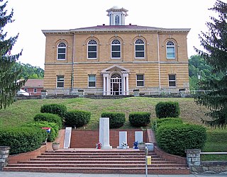
Kanawha County is a county in the U.S. state of West Virginia. As of the 2020 census, the population was 180,745, making it West Virginia's most populous county. The county seat is Charleston, which is also the state capital. Kanawha County is part of the Charleston, WV Metropolitan Statistical Area.

<span class="mw-page-title-main">West Wenatchee, Washington</span> Unincorporated community in Washington, United States

West Wenatchee is a former census-designated place (CDP) and now an unincorporated community in Chelan County, Washington, United States. The United States Census Bureau removed the community at the 2010 census, with most of its former area being merged into Wenatchee city limits, raising the population significantly. The area that was West Wenatchee is part of the Wenatchee–East Wenatchee Metropolitan Statistical Area.

<span class="mw-page-title-main">Gauley Bridge, West Virginia</span> Town in West Virginia, United States

Gauley Bridge is a town in Fayette County, West Virginia, United States. The population was 614 at the 2010 census. The Kanawha River is formed at Gauley Bridge by the confluence of the New and Gauley Rivers. Two miles to the southeast of Gauley Bridge, in Glen Ferris, is Kanawha Falls, a popular stopping point on Midland Trail Scenic Highway.

<span class="mw-page-title-main">Cedar Grove, West Virginia</span> Town in West Virginia, United States

Cedar Grove is a town in Kanawha County, West Virginia, United States. The population was 714 at the 2020 census. Cedar Grove was incorporated in 1902. Its name is derived from the time the town was established, when a large juniper forest, misidentified as cedars by early settlers, was growing at that location. Cedar Grove is the site of Fort Kelley and the oldest settlement in the Kanawha Valley, dating from 1773. Landmarks located here include the Tompkins Home (1844) and the Old Brick Church (1853). The current mayor is James Hudnall.

<span class="mw-page-title-main">Clendenin, West Virginia</span> Town in West Virginia, United States

Clendenin is a town in Kanawha County, West Virginia, United States, situated along the Elk River. The population was 850 at the 2020 census.

<span class="mw-page-title-main">Coal Fork, West Virginia</span> Census-designated place in West Virginia, United States

Coal Fork is an unincorporated census-designated place (CDP) in Kanawha County, West Virginia, United States. It is part of a larger unincorporated community known as Campbells Creek, approximately 10 minutes east of Charleston. The population was 1,233 at the 2010 census.

<span class="mw-page-title-main">Dunbar, West Virginia</span> City in West Virginia, United States

Dunbar is a city in Kanawha County, West Virginia, United States, situated along the Kanawha River. The population was 7,479 at the 2020 census.

<span class="mw-page-title-main">East Bank, West Virginia</span> Town in West Virginia, United States

East Bank is a town in Kanawha County, West Virginia, United States, situated along the Kanawha River. The population was 820 at the 2020 census. East Bank was incorporated in 1889 by special charter enacted by the West Virginia Legislature. It is so named on account of the town's location on the east side of the Kanawha River.

<span class="mw-page-title-main">Jefferson, West Virginia</span> Census-designated place in West Virginia, United States

Jefferson is a census-designated place (CDP) in Kanawha County, West Virginia, United States, along the Kanawha River. The population was 676 at the 2010 census. Jefferson was incorporated on March 22, 1997, but was disincorporated less than a decade later on February 21, 2007.

<span class="mw-page-title-main">Pinch, West Virginia</span> Census-designated place in West Virginia, United States

Pinch is a census-designated place (CDP) in Kanawha County, West Virginia, United States. The population was 3,262 at the 2010 census.

<span class="mw-page-title-main">Pratt, West Virginia</span> Town in West Virginia, United States

Pratt is a town in Kanawha County, West Virginia, United States, along the Kanawha River. The population was 482 at the 2020 census.

<span class="mw-page-title-main">South Charleston, West Virginia</span> City in West Virginia, United States

South Charleston is a city in Kanawha County, West Virginia, United States. It is located to the west of the state capital of Charleston. The population was 13,639 at the 2020 census. It was established in 1906, but not incorporated until 1917. The Criel Mound built circa 0 B.C. by the Adena culture is adjacent to the city’s downtown business district.

<span class="mw-page-title-main">Alum Creek, West Virginia</span> Census-designated place in West Virginia, United States

Alum Creek is a census-designated place (CDP) in Kanawha and Lincoln counties along the Coal River in the U.S. state of West Virginia. It includes the unincorporated communities of Alum Creek, Forks of Coal, and Priestley. The CDP had a population of 1,749 at the 2010 census, down from 1,839 at the 2000 census.

<span class="mw-page-title-main">Leon, West Virginia</span> Town in West Virginia, United States

Leon is a town in Mason County, West Virginia, United States, situated along the Kanawha River. The population was 137 at the 2020 census. It is part of the Point Pleasant, WV–OH Micropolitan Statistical Area.

<span class="mw-page-title-main">Buffalo, West Virginia</span> Town in West Virginia, United States

Buffalo is a town in Putnam County, West Virginia, United States, located along the Kanawha River. The population was 1,211 at the time of the 2020 census It is part of the Huntington–Ashland metropolitan area.

<span class="mw-page-title-main">Reedy, West Virginia</span> Town in West Virginia, United States

Reedy is a town in Roane County, West Virginia, United States. The population was 152 at the 2020 census.

<span class="mw-page-title-main">Mineralwells, West Virginia</span> CDP in West Virginia, United States

Mineralwells, also known as Mineral Wells, is a census-designated place (CDP) in Wood County, West Virginia, United States. It is part of the Parkersburg-Marietta-Vienna, WV-OH Metropolitan Statistical Area. The population was 1,950 at the 2010 census.

<span class="mw-page-title-main">Smithers, West Virginia</span> Place in West Virginia, United States

Smithers is a city in Fayette and Kanawha counties in the U.S. state of West Virginia. Located along the Kanawha River, it lies almost entirely in Fayette County. The population was 751 at the 2020 census. The city most likely takes its name from Smithers Creek. The small river city is noted for having a rich cultural history related to both its coal mining and Italian-American heritages.

References

  1. 1 2 "U.S. Census website". United States Census Bureau . Retrieved May 14, 2011.
  2. 1 2 "U.S. Census website". United States Census Bureau . Retrieved January 31, 2008.
  3. "US Board on Geographic Names". United States Geological Survey. October 25, 2007. Retrieved January 31, 2008.
  4. "People at the Elkview Shopping Center can now retrieve their cars". WOWK . Archived from the original on June 25, 2016. Retrieved June 25, 2016.
  5. "US Gazetteer files: 2010, 2000, and 1990". United States Census Bureau. February 12, 2011. Retrieved April 23, 2011.
  6. "Herbert Hoover High School Breaks Ground in Elkview". WOWK-TV . January 22, 2020. Retrieved December 12, 2020.
  7. "Former Herbert Hoover, Marshall star Corey Bird called up by Miami Marlins".