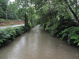
The East River is a tributary of the New River, 24 miles (39 km) long, in southern West Virginia and southwestern Virginia in the United States. Via the New, Kanawha and Ohio rivers, it is part of the watershed of the Mississippi River, draining an area of 76.4 square miles (198 km2) in the Ridge-and-Valley Appalachians.
Tightsqueeze is an unincorporated community in the center of Pittsylvania County, Virginia, United States. It is included in the Danville, Virginia Metropolitan Statistical Area.
The following is a set–index article, providing a list of lists, for the cities, towns and villages within the jurisdictional United States. It is divided, alphabetically, according to the state, territory, or district name in which they are located.

Interstate 81 (I-81) is an 855.02-mile-long (1,376.02 km) Interstate Highway. In the US state of Virginia, I-81 runs for 324.92 miles (522.91 km), making the portion in Virginia longer than any other state's portion of the route. It is also the longest Interstate Highway within the borders of Virginia. It stretches from the Tennessee state line near Bristol to the West Virginia state line near Winchester. It enters Virginia from Bristol, Tennessee, and leaves Virginia into Berkeley County, West Virginia. The route passes through the cities of Bristol, Roanoke, Lexington, Staunton, and Harrisonburg.
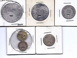
Hot Coal or Hotcoal was an unincorporated community and coal town located along the Winding Gulf Creek in Raleigh County, West Virginia, United States. Originally, it was named Patterson and later acquired the name Hot Coal. It was the next community past Big Stick on County Route 3/2. Although, the community now no longer exists, the Winding Gulf Bank, now the National Bank at Beckley, resided at Hot Coal and was moved to Beckley on January 1, 1914. Hot Coal at one time had a Post Office

Longdale Furnace is an unincorporated community located east of Clifton Forge in Alleghany County, Virginia, United States.

Newport is an unincorporated community in Giles County, Virginia, United States, with the ZIP code of 24128. The 2020 Census reports a population of 1,767 in the community. It is located in a valley between Salt Pond Mountain, Sherman's Nose and Gap Mountain.
Midway is an unincorporated community in Giles County, Virginia. It lies at an elevation of 1,719 feet.
Jumping Branch is an unincorporated community in Summers County, West Virginia, United States, located west of Hinton. The name Jumping Branch originated as settlers had to cross a stream to enter the area by crossing over a fallen tree before it was bridged. The Lilly Crews cemetery is located there as well. Jumping Branch has a post office with ZIP code 25969.
Newport, Virginia may refer to several places:
Lodore is a rural unincorporated community in northern Amelia County just south of the Appomattox River in the U.S. state of Virginia. It is located along SR 616 at its intersection with the northern terminus of SR 636.
Turleytown is an unincorporated community located in Rockingham County, in the U.S. state of Virginia.
Kimballton is an unincorporated community in Giles County, Virginia, United States. Kimballton is located on Stony Creek, 4.2 miles (6.8 km) northeast of Pearisburg. Virginia Tech's Kimballton Underground Research Facility (KURF), a low-background physics laboratory, is located in a limestone mine in Kimballton.

Gill is an unincorporated community and former railroad town in Lincoln County, West Virginia, United States.
Letch is an unincorporated community in Braxton County, West Virginia, United States. Its post office is closed.
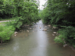
Cabin Creek is a tributary of the Kanawha River, 22.7 miles (36.5 km) long, in West Virginia in the United States. Via the Kanawha and Ohio rivers, it is part of the watershed of the Mississippi River, draining an area of 72.6 square miles (188 km2) in a coal mining region on the unglaciated portion of the Allegheny Plateau.


