Orma is an unincorporated community in Calhoun County, West Virginia, United States. It lies along West Virginia Route 16 and the West Fork Little Kanawha River, to the south of the town of Grantsville, the county seat of Calhoun County. Its elevation is 738 feet. It has a post office with the ZIP code 25268.
Arnoldsburg is an unincorporated community in Calhoun County, West Virginia, United States. It lies along U.S. Route 33 at the point where West Virginia Route 16 heads southward; it is several miles south of the county seat of Grantsville. Its elevation is 738 feet. The West Fork Little Kanawha River flows through the community. It has a post office with the ZIP code 25234.
Creston is an unincorporated community in southeastern Wirt County, West Virginia, United States. It lies at the confluence of the Little Kanawha River and the West Fork Little Kanawha River on West Virginia Route 5, southeast of the town of Elizabeth, the county seat of Wirt County. Its elevation is 653 feet (199 m). Creston had a post office, which closed on June 25, 2011. The community was named for a drainage divide near the town site.
Advent is an unincorporated community in southeastern Jackson County, West Virginia, United States. It lies along Advent Road southeast of the city of Ripley, the county seat of Jackson County, and near Jackson County's borders with Kanawha and Roane counties. Its elevation is 791 feet (241 m). Advent had a post office, which closed on December 25, 2010.
Cleveland is an unincorporated community in Webster County, West Virginia, United States. Cleveland is located 17 miles (27 km) north of Webster Springs on West Virginia Route 20, along the Right Fork Little Kanawha River. Cleveland has a post office with ZIP code 26215.
Kanawha Head is an unincorporated community in Upshur County, West Virginia, United States. Kanawha Head is located on West Virginia Route 20, 16.5 miles (26.6 km) south-southwest of Buckhannon. Kanawha Head had a post office with ZIP code 26228.
Alloy is an unincorporated community in Fayette County, West Virginia, United States. Alloy is located along the Kanawha River and U.S. Route 60, 5 miles (8.0 km) southwest of Gauley Bridge. Alloy was originally known as Boncar until the mid-1930s. Both the original placename and the current placename refer to the ferroalloy plant that still operates here. The metals plant was originally the Electro Metallurgical Co.; a unit of Union Carbide and Carbon Corporation. Alloy has a post office with ZIP code 25002.

Mount Carbon is a census-designated place (CDP) in Fayette County, West Virginia, United States. Mount Carbon is located along West Virginia Route 61, 3 miles (4.8 km) southeast of Montgomery, on the south bank of the Kanawha River at the mouth of Armstrong Creek. Mount Carbon has a post office with ZIP code 25139. As of the 2010 census, its population was 428.
Kanawha Falls is an unincorporated community in Fayette County, West Virginia, United States. Kanawha Falls is located on the east bank of the Kanawha River, 2 miles (3.2 km) southwest of Gauley Bridge and 0.6 miles (0.97 km) downstream from the waterfall of the same name. Kanawha Falls had a post office, which opened on March 26, 1856, and closed on November 2, 2002.
Dawes is an unincorporated community in Kanawha County, West Virginia, United States. Dawes is 5 miles (8.0 km) south of East Bank along Cabin Creek. Dawes has a post office with ZIP code 25054.
Miami is an unincorporated community in Kanawha County, West Virginia, United States. Miami is 4.5 miles (7.2 km) south of East Bank along Cabin Creek. Miami has a post office with ZIP code 25134.
Dry Branch is an unincorporated community in Kanawha County, West Virginia, United States. Dry Branch is 3 miles (4.8 km) southwest of East Bank, along Cabin Creek. Dry Branch has a post office with ZIP code 25061.
Falling Rock is an unincorporated community in Kanawha County, West Virginia, United States. Falling Rock is located at the confluence of Falling Rock Creek with the Elk River 3 miles (4.8 km) southwest of Clendenin along US Route 19. Falling Rock has a post office with ZIP code 25079.
Tad is an unincorporated community in Kanawha County, West Virginia, United States. Tad is 7.5 miles (12.1 km) east of Charleston. Tad has a post office with ZIP code 25201.
Hernshaw is an unincorporated community in Kanawha County, West Virginia, United States. Hernshaw is located on West Virginia Route 94, 2.5 miles (4.0 km) southwest of Marmet, along Lens Creek. Hernshaw has a post office with ZIP code 25107.
Hugheston is an unincorporated community in Kanawha County, West Virginia, United States. Hugheston is located on the north bank of the Kanawha River across from Pratt. Hugheston has a post office with ZIP code 25110. The average household income is $32,436.
Pond Gap is an unincorporated community in Kanawha County, West Virginia, United States. Pond Gap is 7 miles (11 km) north-northeast of Smithers. Pond Gap has a post office with ZIP code 25160.
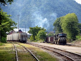
Winifrede is an unincorporated community in Kanawha County, West Virginia, United States. Winifrede is 2.5 miles (4.0 km) southwest of Chesapeake. Winifrede has a post office with ZIP code 25214. It is home of the Big Eagle Railroad, one of the oldest short-line railroad operations in the United States, having been in existence since 1850. The Winifrede Railroad was incorporated in November 1881 and opened in 1882; the original operation was closed in 1988 and reopened as the Big Eagle Railroad in 2000–01.
Grimms Landing is an unincorporated community in Mason County, West Virginia, United States. Grimms Landing is located on the east bank of the Kanawha River along West Virginia Route 62, 4.5 miles (7.2 km) north-northeast of Buffalo.
Robertsburg is an unincorporated community in Putnam County, West Virginia, United States. Robertsburg is located on the east bank of the Kanawha River along West Virginia Route 62, 3 miles (4.8 km) north-northeast of Buffalo. Robertsburg had a post office, which opened on August 6, 1900, and closed on May 10, 1997.


