The San Francisco Municipal Railway ( MEW-nee; SF Muni or Muni), is the primary public transit system within San Francisco, California. It operates a system of bus routes, the Muni Metro light rail system, three historic cable car lines, and two historic streetcar lines. Previously an independent agency, the San Francisco Municipal Railway merged with two other agencies in 1999 to become the San Francisco Municipal Transportation Agency (SFMTA). In 2018, Muni served 46.7 square miles (121 km2) with an operating budget of about $1.2 billion. Muni is the seventh-highest-ridership transit system in the United States, with 142,168,200 rides in 2023, and the second-highest in California after the Los Angeles County Metropolitan Transportation Authority.
Muni Metro is a semi-metro system serving San Francisco, California, United States. Operated by the San Francisco Municipal Railway (Muni), a part of the San Francisco Municipal Transportation Agency (SFMTA), Muni Metro served an average of 68,700 passengers per weekday in the first quarter of 2023, making it the seventh-busiest light rail system in the United States.

The F Market & Wharves line is one of several light rail lines in San Francisco, California. Unlike most other lines in the system, the F line runs as a heritage streetcar service, almost exclusively using historic equipment both from San Francisco's retired fleet as well as from cities around the world. While the F line is operated by the San Francisco Municipal Railway (Muni), its operation is supported by Market Street Railway, a nonprofit organization of streetcar enthusiasts which raises funds and helps to restore vintage streetcars.

The L Taraval is a hybrid light rail/streetcar line of the Muni Metro system in San Francisco, California, mainly serving the Parkside District. Since 2021, the line has been suspended and replaced by buses until the end of 2024 for an improvement project along Taraval Street.

The M Ocean View is a light rail line that is part of the Muni Metro system in San Francisco, California. Named after the Oceanview neighborhood, it runs between San Jose and Geneva and Embarcadero station, connecting Oceanview, San Francisco State University, and Stonestown Galleria with the city center. The line opened on October 6, 1925.

The K Ingleside is a hybrid light rail/streetcar line of the Muni Metro system in San Francisco, California. It mainly serves the West Portal and Ingleside neighborhoods. The line opened on February 3, 1918, and was the first line to use the Twin Peaks Tunnel.

The J Church is a hybrid light rail/streetcar line of the Muni Metro system in San Francisco, California. The line runs between Embarcadero station and Balboa Park station through Noe Valley. Opened on August 11, 1917, it is the oldest and has the lowest ridership of all of the Muni Metro lines.

The Sunset Tunnel, originally known as the Duboce Tunnel, is a 4,232 ft (1,290 m)-long light rail/streetcar tunnel in San Francisco, California. The tunnel runs under the steep hill adjacent to Buena Vista Park and is used exclusively by the N Judah Muni Metro line.
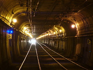
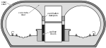
The Twin Peaks Tunnel is a 2.27-mile-long (3.65 km) light rail/streetcar tunnel in San Francisco, California. The tunnel runs under Twin Peaks and is used by the K Ingleside, M Ocean View and S Shuttle lines of the Muni Metro system.

Balboa Park station is a Bay Area Rapid Transit (BART) station and Muni Metro complex in the Mission Terrace neighborhood of San Francisco, California, located near the eponymous Balboa Park. It is an intermodal hub served by four BART routes, three Muni Metro lines, and a number of Muni bus routes. The station complex also includes two rail yards, Cameron Beach Yard and Green Light Rail Center, where Muni maintains Muni Metro trains and heritage streetcars. BART uses a below-grade island platform on the west side of the complex; Muni Metro routes use several smaller side platforms located on surface-level rail loops around the yards.

Fort Mason, in San Francisco, California originated as a coastal defense site during the American Civil War. The nucleus of the property was owned by John C. Frémont and disputes over compensation by the United States continued into 1968. In 1882 the defenses were named for Richard Barnes Mason, a military governor before statehood. Fort Mason became the headquarters for an Army command that included California and the Hawaiian Islands from 1904 to 1907. In 1912 the Army began building a port facility with piers and warehouses to be a home base for ships of the Army Transport Service serving Alaska, Hawaii, the Philippines and other Pacific Army posts and focus of Army supply for the Pacific.

The E Embarcadero is a historic streetcar line that is the San Francisco Municipal Railway's second heritage streetcar line in San Francisco, California. Trial service first ran during the Sunday Streets events on The Embarcadero in 2008. The line initially ran on weekends only, but expanded to weeklong service in late April 2016.

The Pittsburgh Light Rail is a 26.2-mile (42.2 km) light rail system in Pittsburgh, Pennsylvania, and surrounding suburbs. It operates as a deep-level subway in Downtown Pittsburgh, but runs mostly at-grade in the suburbs south of the city. The system is largely linear in a north-south direction, with one terminus near Pittsburgh's central business district and two termini in the South Hills. The system is owned and operated by Pittsburgh Regional Transit. The T is one of the surviving first-generation streetcar systems in North America, with the oldest portions of the network dating back to 1903 and the Pittsburgh Railways. It is also one of only three light rail systems in the United States that continues to use the broad 5 ft 2+1⁄2 in Pennsylvania Trolley Gauge on its lines instead of the 4 ft 8+1⁄2 instandard gauge. In 2023, the system had a ridership of 3,417,100.

Streetcars or trolley(car)s were once the chief mode of public transit in hundreds of North American cities and towns. Most of the original urban streetcar systems were either dismantled in the mid-20th century or converted to other modes of operation, such as light rail. Today, only Toronto still operates a streetcar network essentially unchanged in layout and mode of operation.

The 47D Drake was a PCC trolley line that was part of the Pittsburgh Light Rail system.