Defunct bus lines
This is a listing of all the Local, Rapid, Express, and streetcar lines that once operated throughout San Francisco, but are now defunct.
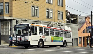
 1950 Muni trolley coach 776 serving the 8 Market line on Market Street at 10th during the 1987 San Francisco Historic Trolley Festival.
 74X Culture Bus in special livery, October 2008.
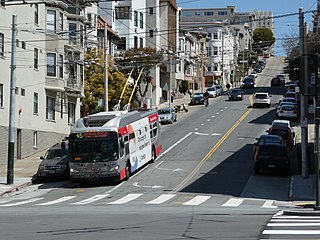
 The 53 Southern Heights was served by short 30-foot (9.1 m) buses, seen here in January 2008.


| * | Weekday peak hours only |
| ^ | Articulated bus (60 ft.) |
| ♦ | Community bus (30 ft.) |
| (TC) | Trolleybus |
Local lines
| Line | Note | Inbound terminal | Outbound terminal | Reason for discontinuing | Areas served | Year started | Year discontinued |
|---|---|---|---|---|---|---|---|
| 1 Westwood Park [1] | |||||||
| 4 Sutter | (TC)* | Sutter Street & Sansome Street | 6th Avenue & California Street | Low ridership; [2] supplemented by 2 Clement re-routing. It was revived for a while when the 1 California moved to Sacramento St.; a truncated version to Presidio to be re-instated. The 2 Sutter trolleybus is its replacement. | Richmond District, Laurel Heights, Western Addition, Japantown, Union Square, Financial District | 1948 | 2009 |
| 5 McAllister | (TC) | Transbay Terminal | La Playa and Balboa streets | Renamed 5 Fulton. [3] | Financial District, Tenderloin, Civic Center, Western Addition, Alamo Square, University of San Francisco, Golden Gate Park, Richmond, Ocean Beach | 1906 | 1948 |
| 7 Haight | (TC)* | Mission Street & Main Street | Haight Street & Stanyan Street | Low ridership; [2] 71 Haight/Noriega was renumbered to 7 Haight/Noriega in 2015. [4] | Haight-Ashbury, Haight-Fillmore, Market Street, Civic Center, Financial District | 1948 | 2009 |
| 8 Market | (TC) | Ferry Building | Collingwood & 19th Streets | Replaced by F Market and subsequently by F Market & Wharves; 9X Bayshore Express was renumbered to 8X Bayshore Express. [5] | The Embarcadero, Market Street, Financial District, Civic Center, The Castro | 1945 | 1995 |
| 8 Seventeenth Avenue | 17th & Judah | 15th & Taraval | [6] | ||||
| 9 Richland | (TC) | Ferry Building | Richland & Andover | Part combined with parts of 13 Ellsworth and 23 Crescent to form 67 Bernal Heights; rest replaced by 26 Valencia (portions replaced by 29 Sunset in 1982)[ citation needed ] | South of Market, Mission District, Bernal Heights | 1949 | 1983 [7] |
| 10 Monterey | 10th Ave & California | 3rd & Palou | Replaced by 23-Monterey and 43-Masonic.[ citation needed ] | Richmond, Golden Gate Park, Inner Sunset, Glen Park, Bernal Heights | |||
| 11 Telegraph Hill | Union & Montgomery | Coit Tower | 1939 [6] | ||||
| 11 Hoffman | Ferry Building | 24th & Douglass via Forest Hill station | Replaced by 13 Guerrero and 48 Quintara/24th Street | South of Market, Mission District, Noe Valley, Diamond Heights, Forest Hill | 1948 | 1983 [7] | |
| 12 Mission/Ocean | (TC) | Ferry Building | Ocean & Phelan | Replaced by 49 Van Ness/Mission | South of Market, Mission District, Bernal Heights, Excelsior, Balboa Park | 1948 | 1983 [7] |
| 13 Ellsworth | Crescent & Putnam | Richland & Mission | Combined with parts of 9 Richland and 23 Crescent to form 67 Bernal Heights. | Bernal Heights | 1970 | 1983 [7] | |
| 13 Guerrero | Ferry Building | Clipper & Grandview | Duplicated service on J Church and 48 Quintara. | South of Market, Mission District, Noe Valley | 1983 [7] | 1988 | |
| 14 Roosevelt | Renamed 43 Roosevelt | 1949 [8] | |||||
| 15 Third Street | ^ | Kearny & Bay Streets | City College | Replaced by T Third Street and 9X Bayshore Express (now 8 Bayshore); [9] and later 15 Bayview Hunters Point Express [10] | Fisherman's Wharf, Chinatown, Union Square, Mission Bay, Dogpatch, Islais Creek, Bayview/Hunters Point, Visitacion Valley | 1941 | 2007 |
| 16 Kearny/Third Street | Replaced by 15 Third Street (now T Third Street) [11] | 1941 | 1946 | ||||
| 16 Noriega | 5th St & Market | 48th Avenue and Ortega | Portions merged with the 28 19th Avenue, 71 (now 7) Haight-Noriega. | Downtown San Francisco, Hayes Valley, Western Addition, Richmond, Sunset | |||
| 17 Parkmerced | ♦ | West Portal Station | Arballo and Acevedo | Renamed 57 Parkmerced. [12] Note that there was an earlier 57 Parkmerced that merged into the 17 Parkmerced, as shown on roll signs. | West Portal, Stonestown Galleria, Parkmerced | 2015 | |
| 20 Ellis | Split into 71 Haight-Noriega (now 7 Haight-Noriega) and 72 Haight-Sunset (now part of 29 Sunset) | 1947 | 1951 | ||||
| 20 Columbus | (TC) Midday hours only | Beale Street & Howard Street | Van Ness Avenue & North Point Street | Low ridership; replaced by 41 Union; there was an earlier 20 Columbus, shown on rollsigns. [2] | Financial District, Fisherman's Wharf, North Beach, Chinatown, Financial District, South of Market | 2007 | 2009 |
| 23 Crescent | 24th & Mission | Putnam & Crescent | Combined with parts of 9 Richland and 13 Ellsworth to form 67 Bernal Heights | Mission District, Bernal Heights | 1940 | 1983 [7] | |
| 25 Bryant | Jackson & Fillmore | Geneva & Santos | Replaced by 9 San Bruno and rest merged with 27 Noe to form 27 Bryant. [7] | Pacific Heights, Nob Hill, Tenderloin, Union Square, South of Market, Mission District, Portola, Visitacion Valley, Sunnydale | 1948 | 1983 | |
| 25 Stanyan | Renamed 33 Stanyan (Now 33 Ashbury/18th Street). | 1983 | |||||
| 26 Valencia | Mission Street & 5th Street | Balboa Park Station, San Francisco State University | Low ridership. [2] | South of Market, Mission District, Glen Park, Balboa Park | 1945 | 2009 [13] | |
| 27 Noe [14] | |||||||
| 29 Visitacion | Mansell & Visitacion | Gillette & Lathrop | Replaced by 56 Rutland. [15] | Visitacion Valley | 1948 | 1980 | |
| 32 Embarcadero | Hyde & Jefferson Streets | Ferry Building, Caltrain Depot | Replaced by E Embarcadero (defunct from 1998–2015) [16] and subsequently by F Market & Wharves and N Judah. | Fisherman's Wharf, Ferry Building, The Embarcadero | 1927 | 2000 | |
| 34 Woodside | Myra & Dalewood | Forest Hill Station | Merged into 36 Teresita. | Mount Davidson, Miraloma Park, Midtown Terrace, Forest Hill | 1961 [17] | ||
| 34/36 Woodside/Teresita | Combination of Lines 34 and 36; renamed 36 Teresita. | ||||||
| 35 Howard | Replaced by the R Howard trolleybus. | 1941 | |||||
| 36 Folsom | Ferry Building | Precita Park | Low ridership. | Bernal Heights, Mission District, SoMa, and Ferry Plaza. | 1896 | 1945 | |
| 36 Miraloma | [17] | ||||||
| 36/52 Special | ♦ | Forest Hill station | Split into 36 Teresita and 52 Excelsior. [18] | Glen Park, San Francisco, Sunnyside, San Francisco, California, Midtown Terrace, and Miraloma. | 2021 | ||
| 40 Commuter | |||||||
| 41 Union/Howard | (TC) | Lyon and Greenwich streets | South Van Ness and Cesar Chavez | Renamed 41 Union; it splits in two with the portion north of Howard remaining the 41 and the southern portion becoming the 12 Folsom/Pacific. [19] | Cow Hollow, Russian Hill, Washington Square, Financial District, SoMa, Mission District. | 1949 | 1970 |
| 42 Evans | Merged into 19 Polk. | 1945 | 1980 | ||||
| 42 Downtown Loop | Caltrain Depot | Split into 47 Van Ness and 10 Townsend to improve service in South of Market. [20] | Financial District, Caltrain Depot, South of Market, Nob Hill, Fisherman's Wharf, Levi Plaza | 1980 | 2001 | ||
| 43 Roosevelt | Partially replaced by 37 Corbett and rest extended and renamed 43 Masonic. | Letterman Hospital, Kaiser Hospital, University of California, San Francisco Medical Center, St. Joseph's Hospital | 1949 [8] | 1980 | |||
| 44 Sansome | 1945 [8] | 1954 [21] | |||||
| 44 Diamond Heights | Replaced by 52 Excelsior | 1971 | 1980 | ||||
| 45 Greenwich | Replaced by 45 Union–Van Ness trolleybus | 1950 | 1982 | ||||
| 45 Union–Van Ness | (TC) | Replaced by 45 Union/Stockton | 1982 | 1988 | |||
| 50 Crocker-Amazon | Replaced by 43 Masonic [ citation needed ] | 1926 | 1980 | ||||
| 51 Silver | Middle Point & Hare | Bosworth & Diamond (Glen Park Station) (Weekdays) / Mission & Silver (Weekends and holidays) | Replaced by 44 O'Shaughnessy | Glen Park, Excelsior District, Portola, Silver Terrace, Bayview-Hunters Point | 1927 | 1980 | |
| 53 Southern Heights | ♦ | 16th Street & Mission Street 16th Street Mission Station; Weekdays 16th Street & Bryant Street Weekends | Connecticut Street & 18th Street | Low ridership. [2] | Mission District, Potrero Hill | 1932 | 2009 |
| 54 Hunters Point | by 1950 | ||||||
| 55 Sacramento | Howard & Main Streets | 6th Avenue & Clement Street | Electrified and merged with 1 California. [5] | Financial District, Chinatown, Nob Hill, Richmond, Laurel Heights | 1942 | 1982 | |
| 55 16th Street | 3rd Street & Mission Bay Boulevard North | Mission & 16th Street | Route east of US 101 was replaced by 22 Fillmore in 2021; the remainder of the route merged with parts of 22's previous alignment to create 55 Dogpatch. [22] | Potrero Hill, Mission District, Mission Bay | 2015 | 2021 | |
| 57 Fitzgerald | by 1950 | ||||||
| 58 Leavenworth | Operated during cable car reconstruction [23] | 1982 | 1984 [24] | ||||
| 69 Crissy Field | Downtown to Crissy Field during fireworks events | by 2000 | |||||
| 70 Hunter's Point | Third | Hunter's Point | [25] | 1944 | 1948 | ||
| 70 Northridge | by 1950 | ||||||
| 70 Lake Merced | Great Highway & John Muir | Daly City Station | Replaced by 17 Parkmerced and 18 46th Avenue. | ||||
| 71 San Francisco Junior College | Ridgewood & Monterey | San Francisco Junior College | [25] | 1946 | |||
| 71 Haight-Noriega | Transbay Terminal | Ortega and 48th Ave. | Renamed 7 Haight/Noriega. [12] | South of Market, Financial District, Civic Center, Lower Haight, Haight-Ashbury, Golden Gate Park, Sunset | 2015 | ||
| 72 Haight/Sunset | Ferry Building (weekday peak) / 5th & Market (all other times) | 19th & Winston (daytime) / Sunset & Lake Merced (mornings and evenings) | Replaced by 29 Sunset. | 1951 | 1983 | ||
| 72 Sunset | Shown on rollsigns; eliminated as redundant with 29 Sunset. | 1983 | |||||
| 73 Lincoln Way | 5th and Market Streets | Sloat & Sunset Boulevards | Split into 71 (now 7) Haight-Noriega and 72 Haight-Sunset. | Financial District, Haight-Ashbury, Sunset District, Parkside | 1991 [26] | ||
| 74 Veterans Hospital | 42nd & Clement | 43rd & Fulton | [25] | 1946 | |||
| 74 King Tut Shuttle | De Young Museum | Cabrillo & Great Highway | [25] | 1979 | |||
| 75 Parklands Shuttle | Bay & Laguna | 48th & Point Lobos | Subsidized by the National Park Service, ran two months for weekends and holidays. [27] | 1979 | |||
| 75 Legion of Honor | [27] | 1946 | 1954 [21] | ||||
| 76 Fort Cronkhite | [27] | ||||||
| 76 Broadmoor | San Jose Avenue & Flournoy | Broadmoor Village | Subsidy by developer discontinued.[ citation needed ] | Daly City | 1949 [27] | 1955 [28] | |
| 76 Marin Headlands | Caltrain Station | Fort Cronkhite | Renamed 76x Marin Headlands Express in 2012. | SoMa, Financial District, Nob Hill, Presidio, Golden Gate Bridge, Marin Headlands, and Fort Cronkhite. | 1976 | 2012 | |
| 77 Alemany | |||||||
| 77 Industrial | Alemany & Sickles | Industrial & Loomis | 1950 [27] | 1954 [27] [21] | |||
| 77 Brotherhood Way [27] | |||||||
| 79 Fort Mason | Hyde & North Point | Fort Mason | Ran two weeks in August. [27] | 1980 | |||
| 79 Sunset Heights | [27] | 1950 | |||||
| 80 Leavenworth | Replaced by 25 Bryant. [27] | 1951 | 1974 | ||||
| 81 Bacon/Fitzgerald | Fitzgerald & Keith | Huron & Mission | Replaced by 29 Sunset and 54 Felton | 1939 | 1982 | ||
| 82 Chinatown | Pacific & Kearny | 4th & Folsom | Merged with present-day 8, 30, and 45 lines | 1980s | |||
| 83 Pacific | Pacific & Van Ness Avenues | Battery Street & Pacific Avenue | Merged into 12 Folsom-Pacific. [29] | Chinatown, Nob Hill | 1979 [30] | 2001 | |
| 84 Shoppers' Shuttle | [30] | 1966 | |||||
| 84 Marina | Downtown to Marina during firework events | by 2000 | |||||
| 85 Shopper Shuttle | |||||||
| 88 Hospital Shuttle | Service absorbed by 10 Monterey [30] | 1970 | 1978 | ||||
| 89 Laguna Honda | ♦ | Forest Hill Station | Laguna Honda Hospital | Low ridership. [2] | Laguna Honda Hospital, Forest Hill | 2009 | |
| 99 BART Shuttle | |||||||
| 108 Treasure Island | Transbay Terminal | 13th and Gateview Treasure Island | Renamed 25 Treasure Island. [12] | South of Market, Treasure Island | 2015 | ||
Limited/Rapid lines
Express lines
| Line | Note | Inbound terminus | Outbound terminus | Reason for discontinuing | Neighborhoods served | Year started | Year discontinued |
|---|---|---|---|---|---|---|---|
| 8X Bayshore Express | ^ | Kearny and North Point | Phelan Loop | Renamed 8 Bayshore. [12] | Fisherman's Wharf, North Beach, Chinatown, Financial District, South of Market, Portola, Visitacion Valley, Excelsior, Crocker-Amazon | 2009 | 2015 |
| 9X Bayshore Express | Renamed 8X Bayshore Express. | 2009 | |||||
| 9AX Bayshore 'A' Express | Kearny and Pacific | Geneva and Schwerin | Renamed 8AX Bayshore 'A' Express. | North Beach, Chinatown, Financial District, South of Market, Portola, Visitacion Valley | |||
| 9BX Bayshore 'B' Express | Kearny and North Point | Phelan Loop | Renamed 8BX Bayshore 'B' Express. | Fisherman's Wharf, North Beach, Chinatown, Financial District, South of Market, Portola, Visitacion Valley, Excelsior, Crocker-Amazon | |||
| 15X Bayshore Express | ^ | Replaced by T Third Street. | 2007 | ||||
| 15AX Bayshore 'A' Express | |||||||
| 15BX Bayshore 'B' Express | |||||||
| 16X Noriega Express | Market Street & 4th Street | Ortega Street & 48th Avenue | Renamed 7X Noriega Express. [12] A different 7X Noriega express went on a slightly different route, as shown on rollsigns. | Tenderloin, Civic Center, Golden Gate Park, Sunset | 2009 | 2015 | |
| 16AX Noriega 'A' Express | Combined with 16BX to become 16X. (now 7X) | Sunset District, Golden Gate Park, Civic Center, Tenderloin | 2009 | ||||
| 16BX Noriega 'B' Express | Noriega Street & Sunset Boulevard | Combined with 16AX to become 16X. (now 7X) | |||||
| 17X Parkmerced Express | John Muir Drive | Daly City BART | Merged into 88 BART Shuttle | Lake Merced, Parkmerced | |||
| 72X Sunset Express | |||||||
| 74X CultureBus | Howard & New Montgomery | Golden Gate Park | Low ridership. [32] | SoMa, Golden Gate Park, Union Square | 2008 | 2009 | |
| 80X Gateway Express | * | 4th and King (Caltrain Depot) | Sacramento and Battery | Replaced by 82X Levi Plaza Express.[ citation needed ] | Financial District, SoMa, South Beach, The East Cut | 2013 | |
| 82x Presidio & Wharves Express | Anza and Lincoin | 4th and King (Caltrain Depot) | Renamed and truncated to create 82x Levi Plaza Express. [33] | SoMa, Financial District, North Beach, Marina District, the Presidio. | 2007 | ||
| 83X Mid-Market Express | ♦* | 9th Street and Market (Civic Center) | Townsend and 5th Street | [34] | Mid-Market, SoMa, Showplace Square, Mission Bay | 2012 | 2020 |
| 87X Civic Center Express |
Candlestick Park lines
Through the end of 2013, the four Candlestick Express lines connected Candlestick Park with other points throughout the city. These lines ran before and after San Francisco 49ers games, while the 86 and 87 Candlestick Shuttles also ran during the game. [35]
| Line | Termini [a] | Neighborhoods served | Links | |
|---|---|---|---|---|
| 75X Candlestick Express | Balboa Park Station | Candlestick Park | Balboa Park | Route map (PDF) |
| 77X Candlestick Express | California and Van Ness Pre-game | Candlestick Park | South of Market, Civic Center, Pacific Heights, Fort Mason (post-game only) | |
| Van Ness and North Point Post-game | ||||
| 78X Candlestick Express | Funston and California | Candlestick Park | Richmond, Golden Gate Park, Sunset, Stonestown Galleria, Crocker-Amazon, Excelsior, Balboa Park | |
| 79X Candlestick Express | Sutter and Sansome | Candlestick Park | Financial District, South of Market | |
| 86 Candlestick Shuttle | Bacon and San Bruno | Candlestick Park | Portola | |
| 87 Candlestick Shuttle | Gilman and Third | Candlestick Park | Bayview-Hunters Point | |
R Howard
The R Howard was a trolleybus line created on September 7, 1941. It ran from Beale and Howard on Howard and South Van Ness Avenue to Army Street (now Cesar Chavez Street). It was combined with the E Union in July 1947, and was renumbered 41 in February 1949. [36]