List of San Francisco Municipal Railway lines

Last updated

The San Francisco Municipal Railway (Muni) is the primary public transit system for San Francisco, California. Muni is part of the San Francisco Municipal Transportation Agency, which is also responsible for the streets, parking, traffic signals, and other transportation in the city. In 2019, Muni had the eighth-highest ridership among systems in the United States, with an average weekday ridership of 684,600. [1] [2] Service is operated to all parts of San Francisco - including Treasure Island - as well as small sections of Daly City and Marin County.

Contents

Muni operates seven light rail lines in the Muni Metro system, two streetcar lines (E Embarcadero and F Market & Wharves), and three cable car lines. Daytime bus service includes 44 local routes, 5 limited-stop "Rapid" routes, and 15 peak-hour express routes. Four additional express routes provide weekend service to the Marin Headlands, service to Oracle Park (home of the San Francisco Giants), and the Chase Center (home of the Golden State Warriors) and supplement BART in the early morning. Overnight night bus "Owl" service - part of the All Nighter network - includes eight 24-hour routes, two night-only routes, three bus replacements of Muni Metro lines, and five-weekend early-morning Muni Metro replacement lines. Fourteen local routes (two only at certain times), one rapid route, and four Owl routes run as electric trolleybuses. Muni service operates out of ten yards and garages: one cable car barn, three light rail/streetcar yards, two trolleybus garages, and four bus garages. [3]

Routes have two-part names like "19 Polk" and "N Judah", where the second portion is usually a street served by the route (or in some cases, a neighborhood or landmark). Light rail and streetcar lines are lettered, while bus routes are numbered. The letter/number scheme was created by Muni, while the two-part naming scheme was created by the Market Street Railway, which Muni absorbed in 1944. [4] :127 The three cable car lines are largely known by name (Powell-Mason, Powell-Hyde, and California), though they are abbreviated to PM, PH, and C on maps, and have internal numbers 59–61 for operational purposes. [5]

Muni began service on December 28, 1912, when the A Geary-Park line was inaugurated, running between the Financial District and the Richmond District on the western side of the city. [4] :27 The streetcar system was expanded over the next 16 years, including the Stockton Street Tunnel in 1914, Twin Peaks Tunnel in 1918 and the Sunset Tunnel in 1928. Muni began operating buses in 1917, and trolleybuses in 1941. [4] :89,111 The city acquired the competing Market Street Railway in 1944, doubling the size of Muni; its purchase of the bankrupt California Street Cable Railroad in 1952 made it the city's sole transit operator. [6] Replacement of streetcars by buses in the 1940s and 1950s left only five streetcar lines; they were converted to Muni Metro light rail in 1980 with the completion of the Market Street subway. Numerous service changes over the lifetime of Muni gave rise to the lines in use today; a number of other lines have been discontinued.

During the COVID-19 pandemic, service was initially reduced to a limited set of "core service" routes, then gradually expanded. As of July 2022, six Muni Metro routes, one streetcar route, one bus replacement for a Muni Metro route, three cable car routes, 43 local bus routes, four Rapid routes, and three express routes are in operation. [7] Several of those routes have been temporarily modified. Twelve overnight Owl routes and one early-morning express route are in operation. [7]

Cable car lines

A cable car on Powell Street in 2015 Cable Car SFO 04 2015 2469.jpg
A cable car on Powell Street in 2015

All three cable car lines are based out of the cable car barn at Mason and Washington.

RouteInbound terminalOutbound terminalRidership [3] Links
California (C) California and Market California and Van Ness 4,000 Link
Powell-Hyde (PH) Powell and Market Hyde and Beach7,800 Link
Powell-Mason (PM)Taylor and Bay5,100 Link

Muni Metro and historic streetcar lines

A PCC streetcar and an ex-Milan streetcar on the F Market & Wharves line at the Ferry Building Muni 1071 and 1815 at the Ferry Building, March 2019.JPG
A PCC streetcar and an ex-Milan streetcar on the F Market & Wharves line at the Ferry Building
An N Judah train at Powell station in 2017 Muni 2006 at Powell station, November 2017.jpg
An N Judah train at Powell station in 2017

Muni runs six Muni Metro light rail lines (J, K, L, M, N, and T), plus a shuttle service (S). The S Shuttle operates as an additional subway service at peak hours; extended S service is also used to serve events at Oracle Park (primarily San Francisco Giants games) and Chase Center (primarily Golden State Warriors games).

Two streetcar lines (E and F) use historic streetcars but serve as full transit routes rather than mere tourist attractions. Muni Metro lines are based out of two yards, Green Division (located at Balboa Park station) and Muni Metro East; the historic streetcar lines are based at Cameron Beach Yard (also near Balboa Park).

All routes except the E Embarcadero and L Taraval are in operation; bus replacements operate for the L Taraval. [7]

RouteInbound terminalOutbound terminalLinks
Jones and Beach
(Fisherman's Wharf)
4th and King
(Caltrain Depot)
Link
17th Street and Castro Link
Embarcadero Balboa Park Link
Link
46th Avenue and Wawona
(SF Zoo)
Link
San Jose and Geneva
(Balboa Park)
Link
4th and King
(Caltrain Depot)
Judah and La Playa
(Ocean Beach)
Link
Embarcadero West Portal Link
Chinatown Sunnydale Link

Local bus lines

A route 5 Fulton bus at the street-level bus plaza at the Transbay Transit Center in 2018 Muni bus at Transbay Transit Center, January 2018.JPG
A route 5 Fulton bus at the street-level bus plaza at the Transbay Transit Center in 2018
A route 18 bus on 46th Avenue in 2018 Muni route 18 bus at 46th Avenue and Taraval, June 2018.JPG
A route 18 bus on 46th Avenue in 2018
Route 21 Hayes and 31 Balboa trolleybuses at Ferry Plaza in 2019 Three Muni trolleybuses on Steuart Street, March 2019.JPG
Route 21 Hayes and 31 Balboa trolleybuses at Ferry Plaza in 2019
A 30-foot (9.1 m) route 37 Corbett bus in Cole Valley in 2018 Muni route 37 bus in Cole Valley, February 2018.jpg
A 30-foot (9.1 m) route 37 Corbett bus in Cole Valley in 2018
A route 49 bus on red transit-only lanes in the Mission District in 2017 Muni route 49 bus at 24th Street station, December 2017.JPG
A route 49 bus on red transit-only lanes in the Mission District in 2017

Muni operates 44 local bus routes. Most routes operate on weekdays and weekends; the 41 and 88 operate only during weekday peak hours. A number of routes have different terminals during evenings and/or weekends. Route 2, which uses diesel hybrid buses, is supplemented by short turn trolleybuses at peak hours. Route 5 uses trolleybuses only during evenings and weekends.

Key to table notes
Electric trolleybus routes
Community routes using 30–32-foot (9.1–9.8 m) buses
^Routes using 60-foot (18 m) articulated buses
NRoutes not operating during COVID-19 pandemic
MRoutes with modified routing during COVID-19 pandemic

Rapid bus lines

A route 9R bus on Market Street in 2019 Muni route 9R bus at Market and Larkin, April 2019.JPG
A route 9R bus on Market Street in 2019

On five high-ridership corridors, local buses are supplemented with rapid buses with limited stops. The Rapid routes largely follow the route of the local buses, with some variations; at times when the 5R and 9R operate, the 5 and 9 are cut back to a shorter route. The 5R, 9R, and 28R operate only on weekdays until 7pm; the 14R and 38R operate every day until 7pm.

RouteNoteInbound terminalOutbound terminalRidership [3] Links
5R Fulton Rapid ^Transbay Transit CenterCabrillo and La Playa12,900 Link
9R San Bruno Rapid^Main and MissionSunnydale and McLaren School11,700 Link
14R Mission Rapid ^Mission and Main Daly City station 18,900 Link
28R 19th Avenue RapidMCalifornia and 6th AvenueDaly City station4,500 Link
38R Geary Rapid ^Transbay Transit CenterPoint Lobos and 48th Avenue29,500 Link

Express bus lines

A route 8BX bus at Balboa Park station Muni route 8BX bus at Balboa Park station, May 2018.JPG
A route 8BX bus at Balboa Park station
A route N bus on 19th Avenue in 2018 Muni route Nx bus on 19th Avenue, September 2018.JPG
A route N bus on 19th Avenue in 2018

Muni operates several types of express routes. Twelve routes operate between outer neighborhoods and downtown. The local sections in the outer neighborhoods overlap with local routes of the same number, while the non-stop express sections operate on expressways or major arterials. They operate only during weekday peak hours, with service only in the peak direction. Buses in the opposite direction run deadhead except for the 8AX and 8BX, which are paired with the local route 8 in the non-peak direction. Eight of the express routes are paired into 'A' and 'B' types, which have different local segments on the same corridor. All express routes except routes 1X, 8AX, 8BX, and 78X are suspended during the COVID-19 pandemic. [7]

RouteNoteInbound terminalOutbound terminalRidership [3] Links
1X California Express ^Davis and Pine (mornings)
Sacramento and Drumm (evenings)
Geary and 33rd AvenueN/A Link
1AX California 'A' Express N ^Davis and Pine Geary and 33rd Avenue1,200 Link
1BX California 'B' Express N ^California and 6th Avenue1,500 Link
7X Noriega Express N ^Market and Steuart (AM)
Main and Market (PM)
Ortega and 48th Avenue1,600 Link
8AX Bayshore 'A' Express^Kearny and PacificGeneva and Schwerin5,800 Link
8BX Bayshore 'B' Express^Kearny and North Point City College (Unity Plaza)5,600 Link
14X Mission Express N ^Steuart and Mission (Ferry Plaza)Mission and San Jose4,200 Link
30X Marina Express N ^Howard and SpearScott and Beach2,000 Link
31AX Balboa 'A' Express NDavis and PineCabrillo and La Playa1,100 Link
31BX Balboa 'B' Express NBalboa and Park Presidio900 Link
38AX Geary 'A' Express NPoint Lobos and 48th Avenue900 Link
38BX Geary 'B' Express N Geary and 25th Avenue1,000 Link
Nx Judah ExpressNBush and Montgomery (AM)
Sutter and Sansome (PM)
Judah and 48th Avenue 1,300 Link
A route 76 bus (renamed 76X in 2012) at the Rodeo Beach parking lot in the Marin Headlands in 2007 Muni route 76X bus at Rodeo Beach, April 2007.jpg
A route 76 bus (renamed 76X in 2012) at the Rodeo Beach parking lot in the Marin Headlands in 2007

Three express routes provide specialized service. The 76X, which runs only on weekends and holidays, provides service to recreational and tourist areas in the Marin Headlands. The 78X and 79X provide service to the Chase Center; they run only before and after events at the arena. [8]

RouteNoteInbound terminalOutbound terminalLinks
76X Marin Headlands ExpressNSutter and Sansome Fort Cronkhite (Marin Headlands) Link
78X 16th Street Arena ExpressN ^Chase Center 16th Street Mission station Link
79X Van Ness Arena ExpressNVan Ness and North Point Link

Two additional routes provide shorter-distance express service between the Caltrain commuter rail terminal at 4th and King station and business areas near Market Street. Like the outer express routes, they operate only at peak hours. The 81X and 82X operate only in the peak direction (the 81X operates only in the morning peak).

RouteNoteInbound terminalOutbound terminalRidership [3] Links
81X Caltrain ExpressNBeale and Howard Townsend and 4th Street 100 Link
82X Levi Plaza ExpressNSansome and Filbert (Levi's Plaza)500 Link

Owl bus lines

A route K Owl bus on Market Street in 2019 Muni K Owl bus on Market Street, March 2019.JPG
A route K Owl bus on Market Street in 2019

Owl routes provide night bus service from 1am to 5am daily (including holidays) as a part of the Bay Area's All Nighter network.

The 90 Owl route is a combination of the daytime 47 Van Ness and 9 San Bruno routes, while the 91 Owl route is a combination of the daytime K Ingleside, 8 Bayshore, T Third, 30 Stockton, and 28 19th Avenue routes. The 5 Fulton, 24 Divisadero, 44 O'Shaughnessy, and 48 Quintara-24th Street Owl routes are truncated from their daytime counterparts.

Route 714 is part of the Early Bird Express system, which provides service while BART performs seismic retrofit earthquake work in the Transbay Tube. It runs a limited number of trips during the early morning between 4am and 5am, while BART is closed. [9]

The K, L, and N Owl motor coaches replace daytime light rail service and run on surface streets, making local stops, rather than in the Market Street subway, Twin Peaks Tunnel, and Sunset Tunnel. The L Owl also covers the route of the daytime F-Market line. The L and N Owl buses run all night, while the K Owl runs only a small number of trips in the early morning and just after the subway closes.

RouteNoteInbound terminalOutbound terminalLinks
5 Fulton Jones and McAllisterCabrillo and La Playa Link
14 Mission Steuart and MissionMission and San Jose Link
22 Fillmore Fillmore and BayMission Bay North and Third Street Link
24 Divisadero Divisadero and SutterCortland and Bayshore Link
25 Treasure IslandTransbay Transit Center13th and Gateview (Treasure Island) Link
38 Geary Point Lobos and 48th Avenue Link
44 O'Shaughnessy Glen Park BART Hudson and Newhall Link

48 24th Street Owl22nd Street and IowaCastro and 24th Street Link
90 San Bruno Owl Van Ness and North PointSan Bruno and Bayshore Link
91 Third Street/19th Avenue Owl Holloway and 19th Avenue West Portal station Link
714 BART Early Bird^Transbay Transit Center Daly City station Link
K OwlNSteuart and Mission Balboa Park station Link
L Owl Jones and Beach Wawona and 46th Avenue Link
N Owl 4th Street and Townsend Ocean Beach Link

Early morning lines

In addition to the Owl service, buses normally provide weekend service along all Muni Metro lines from 5am until rail service begins (6am on Saturdays, 8am on Sundays) to allow for overnight maintenance work in the subway. [10] The K, L, and N Bus routes differ slightly from the nightly Owl routes and do not make local stops along their surface street detours, instead stopping only at stops used by the normal L and N daytime light rail routes. Several of the early morning routes are suspended, while the L bus operates the same shortened route as the daytime bus. [7]

RouteNoteInbound terminalOutbound terminalLinks
J Church BusFerry Plaza
(Embarcadero station)
Balboa Park stationN/A
K Ingleside Bus Link
L Taraval BusM West Portal station Wawona and 46th Avenue Link
M Ocean View BusOnly if neededSan Jose and Geneva
(Balboa Park)
Link
N Judah Bus Townsend and 5th Street Ocean Beach Link
T Third Street Bus Bayshore and Sunnydale Stockton and Washington
(Chinatown station)
Link

Related Research Articles

<span class="mw-page-title-main">San Francisco Municipal Railway</span> Public transport agency in San Francisco, California, USA

The San Francisco Municipal Railway ( MEW-nee; SF Muni or Muni), is the primary public transit system within San Francisco, California. It operates a system of bus routes, the Muni Metro light rail system, three historic cable car lines, and two historic streetcar lines. Previously an independent agency, the San Francisco Municipal Railway merged with two other agencies in 1999 to become the San Francisco Municipal Transportation Agency (SFMTA). In 2018, Muni served 46.7 square miles (121 km2) with an operating budget of about $1.2 billion. Muni is the seventh-highest-ridership transit system in the United States, with 142,168,200 rides in 2023, and the second-highest in California after the Los Angeles County Metropolitan Transportation Authority.

<span class="mw-page-title-main">Muni Metro</span> Light rail system in San Francisco

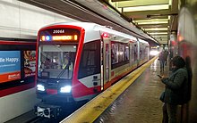
Muni Metro is a semi-metro system serving San Francisco, California, United States. Operated by the San Francisco Municipal Railway (Muni), a part of the San Francisco Municipal Transportation Agency (SFMTA), Muni Metro served an average of 68,700 passengers per weekday in the first quarter of 2023, making it the seventh-busiest light rail system in the United States.

<span class="mw-page-title-main">F Market & Wharves</span> San Francisco heritage streetcar line

The F Market & Wharves line is one of several light rail lines in San Francisco, California. Unlike most other lines in the system, the F line runs as a heritage streetcar service, almost exclusively using historic equipment both from San Francisco's retired fleet as well as from cities around the world. While the F line is operated by the San Francisco Municipal Railway (Muni), its operation is supported by Market Street Railway, a nonprofit organization of streetcar enthusiasts which raises funds and helps to restore vintage streetcars.

<span class="mw-page-title-main">N Judah</span> San Francisco light rail line

The N Judah is a hybrid light rail/streetcar line of the Muni Metro system in San Francisco, California. The line is named after Judah Street that it runs along for much of its length, named after railroad engineer Theodore Judah. It links downtown San Francisco to the Cole Valley and Sunset neighborhoods. The line provides rail access to Golden Gate Park. It is the busiest line in the Muni Metro system, serving an average of 41,439 weekday passengers in 2013. It was one of San Francisco's streetcar lines, beginning operation in 1928, and was partially converted to modern light-rail operation with the opening of the Muni Metro system in 1980. While many streetcar lines were converted to bus lines after World War II, the N Judah remained a streetcar line due to its use of the Sunset Tunnel.

<span class="mw-page-title-main">L Taraval</span> San Francisco light rail line

The L Taraval is a hybrid light rail/streetcar line of the Muni Metro system in San Francisco, California, mainly serving the Parkside District. Since 2021, the line has been suspended and replaced by buses until the end of 2024 for an improvement project along Taraval Street.

<span class="mw-page-title-main">M Ocean View</span> San Francisco light rail line

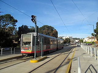
The M Ocean View is a light rail line that is part of the Muni Metro system in San Francisco, California. Named after the Oceanview neighborhood, it runs between San Jose and Geneva and Embarcadero station, connecting Oceanview, San Francisco State University, and Stonestown Galleria with the city center. The line opened on October 6, 1925.

<span class="mw-page-title-main">K Ingleside</span> San Francisco light rail line

The K Ingleside is a hybrid light rail/streetcar line of the Muni Metro system in San Francisco, California. It mainly serves the West Portal and Ingleside neighborhoods. The line opened on February 3, 1918, and was the first line to use the Twin Peaks Tunnel.

<span class="mw-page-title-main">J Church</span> San Francisco light rail line

The J Church is a hybrid light rail/streetcar line of the Muni Metro system in San Francisco, California. The line runs between Embarcadero station and Balboa Park station through Noe Valley. Opened on August 11, 1917, it is the oldest and has the lowest ridership of all of the Muni Metro lines.

<span class="mw-page-title-main">Powell Street station</span> Rapid transit station in San Francisco, California, US

Powell Street station is a combined BART and Muni Metro rapid transit station in the Market Street subway in downtown San Francisco. Located under Market Street between 4th Street and 5th Street, it serves the Financial District neighborhood and surrounding areas. The three-level station has a large fare mezzanine level, with separate platform levels for Muni Metro and BART below. The station is served by the BART Red, Yellow, Green Line, and Blue lines, and the Muni Metro J Church, K Ingleside, L Taraval, M Ocean View, N Judah, and S Shuttle lines.

<span class="mw-page-title-main">T Third Street</span> San Francisco light rail line

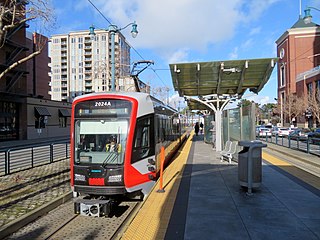
The T Third Street is a Muni Metro light rail line in San Francisco, California. It runs along the east side of San Francisco from Sunnydale to Chinatown, traveling in the median of Third Street for most of its length before entering the Central Subway as it approaches downtown. The line serves 22 stations, all of which are accessible. Most of the surface portion of the line runs in dedicated median lanes, though two portions operate in mixed traffic.

<span class="mw-page-title-main">E Embarcadero</span> San Francisco heritage streetcar line

The E Embarcadero is a historic streetcar line that is the San Francisco Municipal Railway's second heritage streetcar line in San Francisco, California. Trial service first ran during the Sunday Streets events on The Embarcadero in 2008. The line initially ran on weekends only, but expanded to weeklong service in late April 2016.

<span class="mw-page-title-main">38 Geary</span> San Francisco bus route

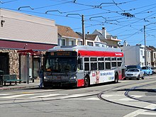
38 Geary is a bus line operated by the San Francisco Municipal Railway (Muni). Together with the limited service routes that share the number, the 38R Geary Rapid, 38AX Geary 'A' Express, and 38BX Geary 'B' Express, the Geary Boulevard corridor makes up Muni's busiest thoroughfare.

<span class="mw-page-title-main">San Francisco Municipal Railway fleet</span> LRV and Bus Fleet of the San Francisco Municipal Railway (Muni)

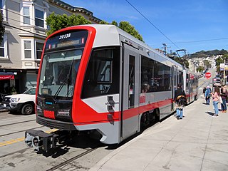
With five different modes of transport, the San Francisco Municipal Railway runs one of the most diverse fleets of vehicles in the United States. Roughly 550 diesel-electric hybrid buses, 300 electric trolleybuses, 250 modern light rail vehicles, 50 historic streetcars and 40 cable cars see active duty.

<span class="mw-page-title-main">The Embarcadero and Brannan station</span>

Brannan and The Embarcadero station is a Muni Metro light rail station located in the median of The Embarcadero south of Brannan Street in the South Beach area of San Francisco, California. Muni Metro trains use a high-level island platform, while historic streetcars use a pair of side platforms at the south end of the station.

<span class="mw-page-title-main">2nd and King station</span> Light rail station in San Francisco, California

2nd and King station is a Muni Metro light rail station located in the median of King Street near Second Street in the China Basin neighborhood of San Francisco, California. It is adjacent to Oracle Park. Muni Metro trains use a high-level island platform, while historic streetcars use a pair of side platforms just to the south.

<span class="mw-page-title-main">Duboce and Church station</span>

Duboce and Church is a light rail stop on the Muni Metro J Church and N Judah lines, located in the Duboce Triangle neighborhood of San Francisco, California. Just east of the station, the two lines enter the Market Street subway. The stop originally opened with the 22 Fillmore line in 1895. The station has complex layout with two side platforms in the middle of Duboce Avenue for the N Judah, one side platform in the middle of Church Street for northbound J Church trains entering the Market Street subway, and two mini-high platforms at the subway portal which provides access to both lines for people with disabilities.

<span class="mw-page-title-main">St. Francis Circle station</span>

St. Francis Circle is a light rail stop on the Muni Metro K Ingleside and M Ocean View lines, located in the St. Francis Wood neighborhood of San Francisco, California. It opened around 1907 when the United Railroads (URR) expanded its Ocean Avenue line west to Ocean Beach; Muni service followed with the K in 1918 and the M in 1925.

<span class="mw-page-title-main">Trolleybuses in San Francisco</span>

The San Francisco trolleybus system forms part of the public transportation network serving San Francisco, in the state of California, United States. Opened on October 6, 1935, it presently comprises 15 lines and is operated by the San Francisco Municipal Railway, commonly known as Muni, with around 300 trolleybuses. In San Francisco, these vehicles are also known as "trolley coaches", a term that was the most common name for trolleybuses in the United States in the middle decades of the 20th century. In 2023, the system had a ridership of 42,240,000, or about 132,300 per weekday as of the fourth quarter of 2023.

<span class="mw-page-title-main">31 Balboa</span> Trolleybus line operated by the San Francisco Municipal Railway

31 Balboa is a trolleybus line operated by the San Francisco Municipal Railway. It is one of several routes operating between the Financial District and the Richmond District.

References

  1. "Transit Ridership Report: Third Quarter 2019" (PDF). American Public Transportation Association. November 22, 2019.
  2. "Connecting Communities: FY 2018-2019 Annual Report" (PDF). San Francisco Municipal Transportation Agency.
  3. 1 2 3 4 5 6 "Short Range Transit Plan: Fiscal Year 2019 - Fiscal Year 2030" (PDF). San Francisco Municipal Transportation Agency. December 2019. pp. 21, 47.
  4. 1 2 3 Perles, Anthony (1981). The People's Railway: The History of the Municipal Railway of San Francisco. Interurban Press. ISBN   0916374424.
  5. "FY11 Q3/Q4 Year-End Service Standards Scorecard – Summary" (PDF). San Francisco Municipal Transportation Agency. August 17, 2011. p. 43. Archived from the original (PDF) on January 7, 2019.
  6. Matoff, Tom (June 1999). "The Muni Paradox — A Brief Social History of the Municipal Railway". Urbanist. San Francisco Planning and Urban Research Association . Retrieved January 15, 2010.
  7. 1 2 3 4 5 "Muni Routes & Stops". San Francisco Municipal Transportation Agency. 8 August 2018. Retrieved July 10, 2022.
  8. Phelan, Lori (August 21, 2019). "New Transit Service to and from Chase Center" (Press release). San Francisco Municipal Transportation Agency.
  9. "Early Bird Express" (PDF). San Francisco Bay Area Rapid Transit District. 2019.
  10. "Permanent Muni Service Changes Starting Saturday, February 22, 2020" (Press release). San Francisco Municipal Transportation Agency. February 22, 2020.