Third Street Light Rail Project

Last updated

Third Street Light Rail
San Francisco-Third St Light Rail.jpg
New tracks on 3rd Street north of 16th Street in September 2005
Overview
Owner San Francisco Municipal Transportation Agency
Locale San Francisco, California
Stations18
Service
Type Light rail
System Muni Metro
Operator(s) San Francisco Municipal Railway
History
OpenedApril 7, 2007
Technical
Line length5.1 miles (8.2 km)
Track gauge 4 ft 8+12 in (1,435 mm)
(standard gauge)
Electrification Overhead lines, 600 V DC
Route map

Contents

BSicon uCONTg.svg
BSicon uSTR.svg
BSicon MFADEg.svg
BSicon uLSTR.svg
E Embarcadero logo.svg N Judah logo.svg
BSicon LSTR+l.svg
BSicon HUBa.svg
BSicon KACCeq.svg
BSicon uSTR+c2.svg
BSicon uSTR3.svg
BSicon uENDEaq.svg
BSicon HUB.svg
BSicon uACCq.svg
BSicon uSTRr+1.svg
BSicon ueABZg+1.svg
BSicon uSTRc4.svg
E Embarcadero logo.svg N Judah logo.svg
BSicon HUBl.svg
BSicon HUBeq.svg
BSicon uACC.svg
Gnome-searchtool.svg 4th and King
Caltrain roundel.svg
BSicon dWASSERq.svg
BSicon uWBRUCKE1.svg
BSicon dWASSERq.svg
4th Street Bridge
over Mission Creek
BSicon uACC.svg
Mission Rock
BSicon uACC.svg
UCSF/Chase Center
BSicon uACC.svg
UCSF Medical Center
BSicon uWSLgl.svg
Mission Bay Loop
BSicon LSTRa.svg
BSicon uACC.svg
20th Street
BSicon BHF.svg
BSicon uSTR.svg
22nd Street
Caltrain roundel.svg
BSicon LSTRe.svg
BSicon uACC.svg
23rd Street
BSicon uABZgl+l.svg
BSicon ulDST~F.svg
BSicon uSTR+r.svg
 
Muni Metro
BSicon uABZgl+l.svg
BSicon ulDST~G.svg
BSicon uSTRr.svg
East Yard
 
BSicon uACC.svg
Marin Street
BSicon dWASSERq.svg
BSicon uWBRUCKE1.svg
BSicon dWASSERq.svg
Levon Hagop Nishkian Bridge
over Islais Creek
BSicon uACC.svg
Evans
BSicon uACC.svg
Hudson/Innes
BSicon uACC.svg
Kirkwood/La Salle
BSicon uACC.svg
Oakdale/Palou
BSicon uACC.svg
Revere/Shafter
BSicon uACC.svg
Williams
BSicon udENDEaq.svg
BSicon uABZgr+r.svg
Armstrong wye
BSicon uACC.svg
Carroll
BSicon uACC.svg
Gilman/Paul
BSicon uACC.svg
Le Conte
BSicon dRP4q.svg
BSicon uSKRZ-G4o.svg
BSicon dRP4q.svg
BSicon tLSTRl.svg
BSicon umKRZt.svg
BSicon tSTR+r.svg
BSicon uACC.svg
BSicon lCONTf@G.svg
Arleta
BSicon uACC.svg
Sunnydale
BSicon uENDExe.svg
BSicon CONTg.svg
BSicon uexKINTe-L.svg
BSicon ACC.svg
BSicon exlINT-R.svg
Bayshore
planned
BSicon CONTf.svg

The Third Street Light Rail Project was the construction project that expanded the Muni Metro system in San Francisco, California, linking downtown San Francisco to the historically underserved southeastern neighborhoods of Bayview-Hunters Point and Visitacion Valley along the eastern side of the city. Construction was finished in late 2006, non-revenue weekend service began on January 13, 2007, and full service began on April 7, 2007. [1] The new service, as the T Third Street Metro line, replaced the 15 Third bus line, which ran south from the Caltrain Depot at 4th and King streets, along Third Street and Bayshore Boulevard to the southeastern neighborhoods.

History

In 1993, the San Francisco Municipal Railway published the Bayshore Transit Study, which offered the following seven goals: [2]

  1. Improve transit service to, from and within the Bayshore corridor (decrease transit times and improve ridership)
  2. Facilitate economic development in the area (stimulate new development and employment)
  3. Enhance the area's environment (air quality and visual improvements)
  4. Enhanced current and planned City & regional transportation (connections to other modes of transportation)
  5. Implement a cost-effective and financially feasible system (minimize operating and capital costs)
  6. Implement project as soon as possible
  7. Implement an equitable system (bringing transit service to citywide levels)

The Bayshore Transit Study presented nine alternatives (including a "do nothing" alternative) ranging from building a trolley coach to expanding the MUNI Metro light rail system. [2] In the two alternative light rail routes proposed, rail service would be extended south to Caltrain's Bayshore Station along Third Street from the Financial District. Potential future extensions studied included lines along Hunter's Point, in Little Hollywood (to Candlestick Park), and along Bayshore and Geneva to the Balboa Park station. [2]

The project was initially budgeted at $667 million. As of July 2006, the budget increased by $120 million. [1]

Route

The T Third starts at Chinatown station, and runs through the Central Subway to the Caltrain Depot at 4th and King streets, then along Third Street. [3] The 15-Third bus line was eliminated and the 8-Bayshore bus line was extended to replace the 15 in areas not served by the metro extension, including City College and Fisherman's Wharf.

The extension was supposed to connect directly to the Bayshore Caltrain Station when the station was in San Francisco County. However, as part of Caltrain's 2004 CTX project, Caltrain relocated the Bayshore Station to San Mateo County without informing Muni. To complicate matters, this connection has been plagued by cost and design issues. As a result, the southern end of the line terminates at the Sunnydale Station on Bayshore Boulevard for the time being.

Features

18 new stations were built along the line. They consist of either island platforms between the tracks or side platforms, with elevated platform heights to allow level boarding with the internal train stairs raised, similar to the ones used by the N Judah along the Embarcadero.

As part of the project, the entire Third Street corridor was repaved and received new streetlights. Additionally, palm trees were planted, sidewalks reconstructed and the pavement on 3rd Street repaved. Stations along the route have a distinctive marquee pole with a sculpture or mobile.

Light rail vehicles (LRVs) operate in an exclusive right-of-way in the center of the street along most of the line to bypass vehicular congestion and increase speed along the line. LRVs operate in mixed flow traffic at the 4th Street Bridge (the bridge does not have enough room for LRV exclusive right-of-way) and in a 10 block segment (from Kirkwood/La Salle stop through Revere/Shafter) in the Bayview business district to maintain parking on both sides of the street for customers of local businesses.

In addition, transit signal priority has been implemented along the entire corridor. The goal is to allow LRVs to have a green light at every intersection so they can travel from station to station without stopping.

Further expansion

The Third Street Light Rail Project is the first part of a multi-phase plan to expand the Muni Metro system. The second phase, known as the Central Subway, removed the need for the T Third to share tracks with N Judah north of 4th and King. T Third was routed to new tracks extending north from the Caltrain depot at 4th and King above ground to a new station at 4th and Brannan, then proceeds underground with intermediate stops at the new stations Yerba Buena/Moscone station and Union Square/Market Street station before terminating at Chinatown station at Stockton and Washington Streets. In addition, the second phase includes short turn service via the new Mission Bay Loop, which was completed in 2019 [4] at a cost of $10.2 million. This improves service to Chase Center. [5] T Third trains began through-running into the Central Subway on January 7, 2023.

In early March 2009, media and community groups proposed that as the Central Subway is being built, plans should be drawn up to extend the T Third past Chinatown through North Beach and Fisherman's Wharf neighborhoods, passing Pier 39, potentially using an old steam railroad line underneath Fort Mason and ending up at The Presidio. [6] These plans were presented in October 2014 as a third phase (northern extension to Fisherman's Wharf) and a conceptual fourth phase (extension west to the Presidio). [7] Formal planning for a Central Subway extension was kicked off in late 2018 with several community meetings, and an Alternatives Study is underway with a projected completion in late 2019. [8] [9]

Related Research Articles

<span class="mw-page-title-main">San Francisco Municipal Railway</span> Public transport agency in San Francisco, California, USA

The San Francisco Municipal Railway ( MEW-nee; SF Muni or Muni), is the primary public transit system within San Francisco, California. It operates a system of bus routes, the Muni Metro light rail system, three historic cable car lines, and two historic streetcar lines. Previously an independent agency, the San Francisco Municipal Railway merged with two other agencies in 1999 to become the San Francisco Municipal Transportation Agency (SFMTA). In 2018, Muni served 46.7 square miles (121 km2) with an operating budget of about $1.2 billion. Muni is the seventh-highest-ridership transit system in the United States, with 142,168,200 rides in 2023, and the second-highest in California after the Los Angeles County Metropolitan Transportation Authority.

<span class="mw-page-title-main">Muni Metro</span> Light rail system in San Francisco

Muni Metro is a semi-metro system serving San Francisco, California, United States. Operated by the San Francisco Municipal Railway (Muni), a part of the San Francisco Municipal Transportation Agency (SFMTA), Muni's light rail lines saw an average of 75,500 boardings per day as of the fourth quarter of 2023 and a total of 24,324,600 boardings in 2023, making it the sixth-busiest light rail system in the United States.

<span class="mw-page-title-main">N Judah</span> San Francisco light rail line

The N Judah is a hybrid light rail/streetcar line of the Muni Metro system in San Francisco, California. The line is named after Judah Street that it runs along for much of its length, named after railroad engineer Theodore Judah. It links downtown San Francisco to the Cole Valley and Sunset neighborhoods. The line provides rail access to Golden Gate Park. It is the busiest line in the Muni Metro system, serving an average of 41,439 weekday passengers in 2013. It was one of San Francisco's streetcar lines, beginning operation in 1928, and was partially converted to modern light-rail operation with the opening of the Muni Metro system in 1980. While many streetcar lines were converted to bus lines after World War II, the N Judah remained a streetcar line due to its use of the Sunset Tunnel.

<span class="mw-page-title-main">M Ocean View</span> San Francisco light rail line

The M Ocean View is a light rail line that is part of the Muni Metro system in San Francisco, California. Named after the Oceanview neighborhood, it runs between San Jose and Geneva and Embarcadero station, connecting Oceanview, San Francisco State University, and Stonestown Galleria with the city center. The line opened on October 6, 1925.

<span class="mw-page-title-main">K Ingleside</span> San Francisco light rail line

The K Ingleside is a hybrid light rail/streetcar line of the Muni Metro system in San Francisco, California. It mainly serves the West Portal and Ingleside neighborhoods. The line opened on February 3, 1918, and was the first line to use the Twin Peaks Tunnel.

<span class="mw-page-title-main">S Shuttle</span> San Francisco light rail line

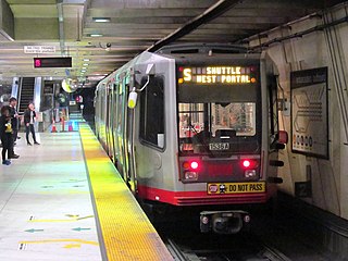
The S Shuttle is a light rail service on the Muni Metro system in San Francisco, California. The service began in 2001 as the S Castro Shuttle, an effort to reduce crowding at Castro station. It was briefly discontinued in 2007 when the T Third Street line was opened. Service was extended to St. Francis Circle station in 2013, but cut back to West Portal station in 2016. In 2020, it was changed to full-time service as part of a reconfiguration of Muni Metro service.

<span class="mw-page-title-main">Central Subway (San Francisco)</span> Underground light rail line

The Central Subway is a Muni Metro light rail tunnel in San Francisco, California, United States. It runs between Chinatown station in Chinatown and a portal in South of Market (SoMa), with intermediate stops at Union Square/Market Street station in Union Square and Yerba Buena/Moscone station in SoMa. A surface portion runs through SoMa to connect to the previously existing T Third Street line at 4th and King station.

<span class="mw-page-title-main">Market Street subway</span> BART-Muni Metro main line, San Francisco

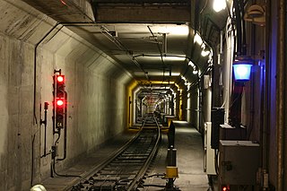
The Market Street subway is a two-level subway tunnel that carries Muni Metro and BART trains under Market Street in San Francisco, California. It runs under the length of Market Street between Embarcadero station and Castro station. The upper level is used by Muni Metro lines and the lower level is used by BART lines. BART does not run through the whole subway; it turns south and runs under Mission Street southwest of Civic Center/UN Plaza station. The northeastern end of the BART level is connected to the Transbay Tube. On the Muni Metro level, the southwestern end of the Market Street subway connects to the much-older Twin Peaks Tunnel, and the northeastern end connects to surface tracks along the Embarcadero.

<span class="mw-page-title-main">T Third Street</span> San Francisco light rail line

The T Third Street is a Muni Metro light rail line in San Francisco, California. It runs along the east side of San Francisco from Sunnydale to Chinatown, traveling in the median of Third Street for most of its length before entering the Central Subway as it approaches downtown. The line serves 22 stations, all of which are accessible. Most of the surface portion of the line runs in dedicated median lanes, though two portions operate in mixed traffic.

<span class="mw-page-title-main">E Embarcadero</span> San Francisco heritage streetcar line

The E Embarcadero is a historic streetcar line that is the San Francisco Municipal Railway's second heritage streetcar line in San Francisco, California. Trial service first ran during the Sunday Streets events on The Embarcadero in 2008. The line initially ran on weekends only, but expanded to weeklong service in late April 2016.

<span class="mw-page-title-main">San Francisco 4th and King Street station</span> Train station in San Francisco, California, U.S.

San Francisco 4th and King Street station, also known as the Caltrain Depot, is a train station in the SoMa district of San Francisco, California. It is presently the northern terminus of the Caltrain commuter rail line serving the San Francisco Peninsula and Santa Clara Valley. It is also the eastern terminus of the N Judah and E Embarcadero, as well as a stop along the T Third Street of the Muni network. The station is additionally the projected terminus for the first phase of the California High-Speed Rail project and a station once Phase 2 is completed.

<span class="mw-page-title-main">Bayshore station (Caltrain)</span> Train station in San Francisco, California, U.S.

Bayshore station is a Caltrain commuter rail station in the Visitacion Valley neighborhood of San Francisco, California. The station is on the border of San Francisco and the neighboring city of Brisbane. The parking lot and the northern section of the station are in San Francisco, while the remainder is in Brisbane. The station address is in San Francisco proper.

<span class="mw-page-title-main">The Embarcadero and Folsom station</span>

The Embarcadero and Folsom station is a Muni Metro light rail station located in the median of The Embarcadero between Folsom Street and Harrison Street in the Rincon Hill area of San Francisco, California. Muni Metro trains use a high-level island platform, while historic streetcars use a pair of side platforms at the southeast end of the station next to the Harrison Street grade crossing.

<span class="mw-page-title-main">The Embarcadero and Brannan station</span>

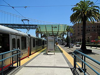
Brannan and The Embarcadero station is a Muni Metro light rail station located in the median of The Embarcadero south of Brannan Street in the South Beach area of San Francisco, California. Muni Metro trains use a high-level island platform, while historic streetcars use a pair of side platforms at the south end of the station.

<span class="mw-page-title-main">2nd and King station</span> Light rail station in San Francisco, California

2nd and King station is a Muni Metro light rail station located in the median of King Street near Second Street in the China Basin neighborhood of San Francisco, California. It is adjacent to Oracle Park. Muni Metro trains use a high-level island platform, while historic streetcars use a pair of side platforms just to the south.

<span class="mw-page-title-main">Arleta station</span> Rail stop in San Francisco

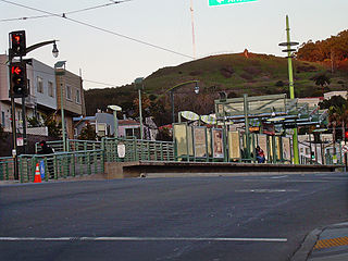
Arleta station is a light rail station on the Muni Metro T Third Street line in the Visitacion Valley neighborhood of San Francisco, California on the south slope of Candlestick Hill. The station opened with the T Third Street line on January 13, 2007. It has a single island platform located in the median of Bayshore Boulevard between Arleta Avenue and Blanken Avenue, with access from crosswalks at both streets.

<span class="mw-page-title-main">Sunnydale station</span> Light rail station in San Francisco, California

Sunnydale station is a light rail station on the Muni Metro T Third Street line, located in the median of Bayshore Boulevard in the Visitacion Valley neighborhood of San Francisco, California, United States. The station opened as the terminus of the T Third Street line on April 7, 2007. It has a single island platform north of Sunnydale Avenue. Tail tracks and a crossover for trains to reverse direction are located south of Sunnydale Avenue.

<span class="mw-page-title-main">Chinatown station (Muni Metro)</span> Subway station in San Francisco, California, US

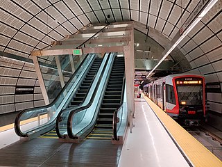
Chinatown station is an underground Muni Metro light rail station, located under Stockton Street at Washington Street in the Chinatown neighborhood of San Francisco, California. It opened on November 19, 2022, as part of the Central Subway project. The station's official name honors Rose Pak, a political activist in the Chinatown community who helped secure support and funding for the station and the extension of the T Third Street line.

<span class="mw-page-title-main">4th and Brannan station</span> Light rail station in San Francisco, California, US

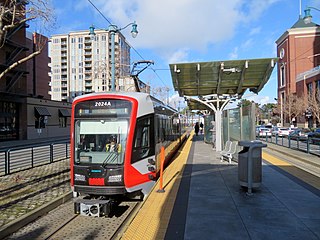
4th and Brannan station is an at-grade Muni Metro light rail station located in the median of 4th Street at Brannan Street in the South of Market (SoMa) district of San Francisco, California. It opened on November 19, 2022, as part of the Central Subway project. The station is served by the T Third Street line which runs between Chinatown and Sunnydale.

References

  1. 1 2 Cabanatuan, Michael (January 13, 2007). "Muni's Third St. light-rail line finally rolling". San Francisco Chronicle. Retrieved March 18, 2013.
  2. 1 2 3 Wilbur Smith Associates (1993). Bayshore Transit Study (Report). City and County of San Francisco, San Francisco Municipal Railway. Retrieved March 10, 2017.
  3. Ward, Christopher. "New T Third Connecting Chinatown to Sunnydale Starts Saturday". New T Third Connecting Chinatown to Sunnydale Starts Saturday | SFMTA. SFMTA. Retrieved February 22, 2023.
  4. Cohen, Bettina (September 2019). "Efforts Continue to Improve Mission Bay Mobility in the Face of New Demands". The Potrero View. Retrieved June 16, 2021.
  5. Rodriguez, Joe Fitzgerald (July 23, 2018). "Cost for long delayed Muni 'loop' to boost Warriors train service jumps $1.4 million". The Examiner. Retrieved July 24, 2018.
  6. Cabanatuan, Michael (November 26, 2014). "Extending S.F.'s Central Subway would draw riders, study says". San Francisco Chronicle. Retrieved March 10, 2017.
  7. T-Third – Phase 3 Concept Study (PDF) (Report). San Francisco Municipal Transportation Agency, Sustainable Streets Division. October 2014. Retrieved March 10, 2017.
  8. Rodriguez, Joe Fitzgerald (December 8, 2018). "Marina District may be on board for Central Subway extension". San Francisco Examiner. Retrieved December 10, 2018.
  9. "Central Subway Extension Alternatives Study" (PDF). San Francisco Municipal Transportation Agency. September 27, 2018. Retrieved December 10, 2018.