
Arthur St. Clair was a Scottish-American soldier and politician. Born in Thurso, Scotland, he served in the British Army during the French and Indian War before settling in Pennsylvania, where he held local office. During the American Revolutionary War, he rose to the rank of major general in the Continental Army, but lost his command after a controversial retreat from Fort Ticonderoga.

Little Turtle was a Sagamore (chief) of the Miami people, who became one of the most famous Native American military leaders. Historian Wiley Sword calls him "perhaps the most capable Indian leader then in the Northwest Territory," although he later signed several treaties ceding land, which caused him to lose his leader status during the battles which became a prelude to the War of 1812. In the 1790s, Mihšihkinaahkwa led a confederation of native warriors to several major victories against U.S. forces in the Northwest Indian Wars, sometimes called "Little Turtle's War", particularly St. Clair's defeat in 1791, wherein the confederation defeated General Arthur St. Clair, who lost 900 men in the most decisive loss by the U.S. Army against Native American forces.

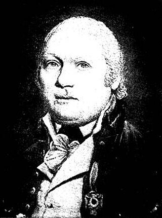
Josiah Harmar was an officer in the United States Army during the American Revolutionary War and the Northwest Indian War. He was the senior officer in the Army for six years and seven months.

The Northwest Territory, also known as the Old Northwest and formally known as the Territory Northwest of the River Ohio, was formed from unorganized western territory of the United States after the American Revolution. Established in 1787 by the Congress of the Confederation through the Northwest Ordinance, it was the nation's first post-colonial organized incorporated territory.

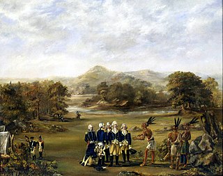
The Treaty of Greenville, also known to Americans as the Treaty with the Wyandots, etc., but formally titled A treaty of peace between the United States of America, and the tribes of Indians called the Wyandots, Delawares, Shawanees, Ottawas, Chippewas, Pattawatimas, Miamis, Eel Rivers, Weas, Kickapoos, Piankeshaws, and Kaskaskias was a 1795 treaty between the United States and indigenous nations of the Northwest Territory, including the Wyandot and Delaware peoples, that redefined the boundary between indigenous peoples' lands and territory for European American community settlement.

The Symmes Purchase, also known as the Miami Purchase, was an area of land totaling roughly 311,682 acres in what is now Hamilton, Butler, and Warren counties of southwestern Ohio, purchased by Judge John Cleves Symmes of New Jersey in 1788 from the Continental Congress.
The Northwest Indian War (1785–1795), also known by other names, was an armed conflict for control of the Northwest Territory fought between the United States and a united group of Native American nations known today as the Northwestern Confederacy. The United States Army considers it the first of the American Indian Wars.
Kekionga, also known as Kiskakon or Pacan's Village, was the capital of the Miami tribe. It was located at the confluence of the Saint Joseph and Saint Marys rivers to form the Maumee River on the western edge of the Great Black Swamp in present-day Indiana. Over their respective decades of influence from colonial times to after the American Revolution, French and Indian Wars, and the Northwest Indian Wars, the French, British and Americans all established trading posts and forts at the large village, originally known as Fort Miami, due to its key location on the portage connecting Lake Erie to the Wabash and Mississippi rivers. The European-American town of Fort Wayne, Indiana started as a settlement around the American Fort Wayne stockade after the War of 1812.

Fort Recovery was a United States Army fort ordered built by General "Mad" Anthony Wayne during what is now termed the Northwest Indian War. Constructed from late 1793 and completed in March 1794, the fort was built along the Wabash River, within two miles of what became the Ohio state border with Indiana. A detachment of Wayne's Legion of the United States held off an attack from combined Indian forces on June 30, 1794. The fort was used as a reference in drawing treaty lines for the 1795 Treaty of Greenville, and for later settlement. The fort was abandoned in 1796.
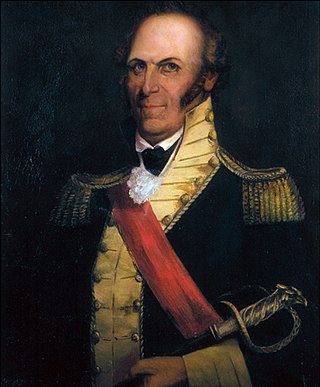
Charles Scott was an American military officer and politician who served as the governor of Kentucky from 1808 to 1812. Orphaned in his teens, Scott enlisted in the Virginia Regiment in October 1755 and served as a scout and escort during the French and Indian War. He quickly rose through the ranks to become a captain. After the war, he married and engaged in agricultural pursuits on land left to him by his father, but he returned to active military service in 1775 as the American Revolution began to grow in intensity. In August 1776, he was promoted to colonel and given command of the 5th Virginia Regiment. The 5th Virginia joined George Washington in New Jersey later that year, serving with him for the duration of the Philadelphia campaign. Scott commanded Washington's light infantry, and by late 1778 was also serving as his chief of intelligence. Furloughed at the end of the Philadelphia campaign, Scott returned to active service in March 1779 and was ordered to South Carolina to assist General Benjamin Lincoln in the southern theater. He arrived in Charleston, South Carolina, just as Henry Clinton had begun his siege of the city. Scott was taken as a prisoner of war when Charleston surrendered. Paroled in March 1781 and exchanged for Lord Rawdon in July 1782, Scott managed to complete a few recruiting assignments before the war ended.

The Treaty of Fort Harmar (1789) was an agreement between the United States government and numerous Native American tribes with claims to the Northwest Territory.

Cincinnati began with the settlement of Columbia, Losantiville, and North Bend in the Northwest Territory of the United States beginning in late December 1788. The following year Fort Washington, named for George Washington, was established to protect the settlers.
James Fontaine or James Fountaine (1757–1790) was an officer who served in American Revolutionary War and the Northwest Indian War.
David Ziegler was a German immigrant to the United States who served in the U.S. military and became the first mayor of Cincinnati, Ohio.
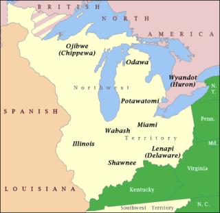
The Northwestern Confederacy, or Northwestern Indian Confederacy, was a loose confederacy of Native Americans in the Great Lakes region of the United States created after the American Revolutionary War. Formally, the confederacy referred to itself as the United Indian Nations, at their Confederate Council. It was known infrequently as the Miami Confederacy since many contemporaneous federal officials overestimated the influence and numerical strength of the Miami tribes based on the size of their principal city, Kekionga.

The Harmar campaign was an attempt by the United States Army to subdue confederated Native Americans nations in the Northwest Territory that were seen as hostile in Autumn 1790. The campaign was led by General Josiah Harmar and is considered a significant campaign of the Northwest Indian War. The campaign ended with a series of battles on 19–22 October 1790 near the Fort Miami and Miami village of Kekionga. These were all overwhelming victories for the Native Americans and are sometimes collectively referred to as Harmar's Defeat.

St. Clair's defeat, also known as the Battle of the Wabash, the Battle of Wabash River or the Battle of a Thousand Slain, was a battle fought on 4 November 1791 in the Northwest Territory of the United States. The U.S. Army faced the Western Confederacy of Native Americans, as part of the Northwest Indian War. It was "the most decisive defeat in the history of the American military" and its largest defeat ever by Native Americans.

The siege of Dunlap's Station was a battle that took place on January 10–11, 1791, during the Northwest Indian War between the Northwestern Confederacy of American Indians and European-American settlers in what became the southwestern region of the U.S. state of Ohio. This was one of the Indians' few unsuccessful attacks during this period. It was shortly after the Harmar Campaign attacks and unprecedented defeat of U.S. Army forces.
Fort St. Clair was a fort built during the Northwest Indian War near the modern town of Eaton, Preble County, Ohio. The site of the fort was listed on the National Register of Historic Places in 1970.
Asa Hartshorne was a United States Army officer who died in 1794 during the Northwest Indian War. He was among the signers of the Treaty with the Six Nations and the Treaty with the Wyandot at Fort Harmar on January 9, 1789. Hartshorne became the namesake of a 1790 frontier skirmish near Maysville, Kentucky.


