Glen Oaks, Baltimore

Last updated
Glen Oaks
neighborhood statistical area
Coordinates: 39°22′00″N76°35′46″W / 39.3666°N 76.5962°W / 39.3666; -76.5962 Coordinates: 39°22′00″N76°35′46″W / 39.3666°N 76.5962°W / 39.3666; -76.5962 [1]
Country United States
State Maryland
City Baltimore
Area [2]
  Total .352 sq mi (0.91 km2)
  Land .352 sq mi (0.91 km2)
Population (2009) [2]
  Total 3,012
  Density 8,600/sq mi (3,300/km2)
Time zone Eastern (UTC-5)
  Summer (DST) EDT (UTC-4)
ZIP code 21239 and 21212
Area code 410, 443, and 667

Glen Oaks is a neighborhood in the North District of Baltimore. Its boundaries form a slender, inverted triangle, with the city line as the neighborhood's northern base and Belvedere Shopping Center as its southern apex. Chinquapin Parkway (west) and The Alameda (east) draw the triangle's sides and cross at the neighborhood's southern tip. [1]

Baltimore Largest city in Maryland

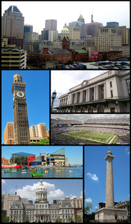
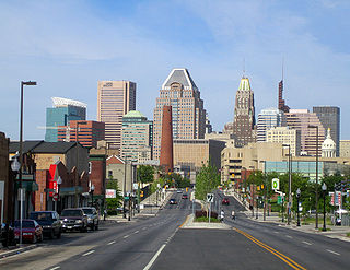
Baltimore is the largest city in the state of Maryland within the United States. Baltimore was established by the Constitution of Maryland as an independent city in 1729. With a population of 611,648 in 2017, Baltimore is the largest such independent city in the United States. As of 2017, the population of the Baltimore metropolitan area was estimated to be just under 2.808 million, making it the 20th largest metropolitan area in the country. Baltimore is located about 40 miles (60 km) northeast of Washington, D.C., making it a principal city in the Washington-Baltimore combined statistical area (CSA), the fourth-largest CSA in the nation, with a calculated 2017 population of 9,764,315.

Contents

Most of the homes in Glen Oaks are brick row houses, built in 1948 by Elba Construction, Inc. [3]

The neighborhoods of Chinquapin Park-Belevedere, Lake Walker and Cameron Village are located to the west of Glen Oaks, on the opposite side Chinquapin Park. Idlewood, Ramblewood and Woodbourne Heights are located to the east, across The Alameda in the Northeast District.

Cameron Village is a neighborhood in the North District of Baltimore, located between the neighborhoods of Mid-Govans and Woodbourne Heights. Vaguely bell-shaped, its boundaries are marked by Bradhurst Road and E. Belvedere Avenue (north), Woodbourne Avenue (south), Lothian Road (west) and Northwood Drive (east).

Ramblewood is a small community located in northeast Baltimore, Maryland, United States. Ramblewood is located south of Northern Parkway with The Alameda serving as its western boundary and Loch Raven Blvd. as its eastern boundary and north of Belvedere Ave. The Ramblewood Community Association has had residential parking permits issued to its members as the result of the proliferation of students from Morgan parking in the neighborhood.

Woodbourne Heights, Baltimore is a community in northern Baltimore, Maryland. It is served by the Woodbourne Heights Community, the Woodbourne-McCabe Neighborhood and the Beauregard Neighborhood Associations.

Route 36 (MTA Maryland) provides bus service along The Alameda, connecting Glen Oaks residents with Downtown Baltimore. Route 44 (MTA Maryland) provides cross-town service along Belvedere Avenue.

Route 36 (MTA Maryland)

Route 36 is a bus route operated by the Maryland Transit Administration in Baltimore and its suburbs. The line currently runs from the intersection of York Road and Northern Parkway to the Riverview, with some trips making short turns at Washington Boulevard and Monroe Street. The line serves the corridors of The Alameda, Kirk Avenue, Guilford Avenue, and Washington Boulevard.

Downtown Baltimore Place in Maryland, United States

Downtown Baltimore is the central business district of Baltimore traditionally bounded by Martin Luther King, Jr. Boulevard to the west, Mt. Royal Avenue to the north, President Street to the east and the Inner Harbor area to the south. It consists of five neighborhoods: Westside, Mount Vernon, City Centre, Inner Harbor, and Camden Yards.

Route 44 (MTA Maryland)

Route 44 is a bus route operated by the Maryland Transit Administration in Baltimore and its suburbs. The line currently runs from Rosedale Industrial Park near Pulaski Highway just outside the Baltimore city limits on the east side of the city across the northern portion of the city to Security Square Mall, with selected peak hour trips to the Social Security Administration. Some early morning trips before 7 AM lay over at the Centers for Medicare and Medicaid Services (CMS) headquarters. The line operates mostly along Frankford Avenue, Echodale Avenue, East Belvedere Avenue, Northern Parkway, Rogers Avenue, and Gwynn Oak Avenue, serving the communities of Gardenville, Hamilton, Belvedere Park, Homeland, Roland Park, Pimlico, and Arlington, and the western suburb of Woodlawn.

Median household income for Glen Oaks in 2009 was estimated at $44,821, while the citywide median was only $38,772. Residents living below the poverty level were 12.5 percent of the Glen Oaks population and 22.9 percent of the Baltimore population. About 3/4 of the Glen Oaks population of 3,012 (census estimate for 2009) were black and almost 1/4 were white. [2]

See also

List of Baltimore neighborhoods

Related Research Articles

Pigtown, Baltimore neighborhood in the southern area of Baltimore, Maryland, United States

"Pigtown", also known as "Washington Village", is a neighborhood in the southern area of Baltimore, bordered by Martin Luther King Jr. Boulevard to the east, Monroe Street to the west, Russell Street to the south, and West Pratt Street to the north. The neighborhood acquired its name during the second half of the 19th century, when the area was the site of butcher shops and meat packing plants to process pigs transported from the Midwest on the B&O Railroad; they were herded across Ostend and Cross Streets to be slaughtered and processed.

Northern Parkway is a major road that runs west–east across the northern part of the city Baltimore. For most of the way, it is at least six lanes wide, and it is used by motorists for crosstown travel. It is designated E. Northern Pkwy and W. Northern Pkwy with Charles Street being the dividing line. It was constructed in the 1950s through several neighborhoods and several homes were razed in the process from right-of-way. The section of E. Northern Pkwy from Harford Road to Fleetwood Ave was originally called German Lane.

Dorchester, Baltimore neighborhood statistical area in Baltimore, Maryland, United States

Dorchester is a neighborhood in the Northwest District of Baltimore. It is located between the neighborhoods of Arlington (north), Central Forest Park (south), Howard Park (west) and Gallway-Garrison (east). Maryland Route 26 draws boundary between Dorchester and Central Forest Park. Dorchester's other boundaries are marked by Oakford Avenue, Eldorado Avenue and Garrison Boulevard.

The Orchards is a neighborhood in the North District of Baltimore, located between the neighborhoods of New North Roland Park–Poplar Hill and Bellona–Gittings. Its boundaries are marked by the Baltimore County line (north), Maryland Route 133 Northern Parkway (south), and Maryland Route 139 Charles Street (east). Roland Avenue, West Lake Avenue, Kenmore Road and Melrose Avenue draw the neighborhood's west boundary.

Edgecomb, also known as Parklane, is a neighborhood in the North District of Baltimore, located between the neighborhoods of Cylburn (north) and Greenspring (south). Its boundaries are marked by Dupont Avenue (north), Coldspring Lane (south), Pimlico Road (west) and Greenspring Avenue (east). Central Park Heights, is located on the opposite side of Pimlico Road in the Northwest District. The neighborhood of Coldspring is located to Edgecomb's east, across Greenspring Avenue.

Cylburn, Baltimore neighborhood statistical area in Baltimore, Maryland, United States

Cylburn is a neighborhood in the North District of Baltimore, located between the neighborhoods of Levindale (north) and Edgecomb (south). Its boundaries are marked by Cylburn Avenue (north), Dupont Avenue (south), Pimlico Road (west) and Greenspring Avenue (east). Central Park Heights, is located on the opposite side of Pimlico Road in the Northwest area of Baltimore City. Cylburn Arboretum and the neighborhood of Cold Spring are located to Cylburn's east, across Greenspring Avenue. The heavily wooded property with its historic mansion and grounds, walking trails, famous collections and gardens overlook the Jones Falls Valley with the Jones Falls Expressway further to the east.

Sabina Mattefeldt, Baltimore neighborhood statistical area in Baltimore, Maryland, United States

Sabina Mattefeldt is a neighborhood in the North District of Baltimore, located beside the Jones Falls, between the neighborhoods of Mount Washington (west) and Poplar Hill (east). Its name comes from the two streets, Sabina Avenue and Mattefeldt Avenue, where most of the neighborhhood's homes are located.

Garwyn Oaks, Baltimore neighborhood statistical area in Baltimore, Maryland, United States

Garwyn Oaks is a neighborhood in the Northwest District of Baltimore, located between the neighborhoods of Windsor Hills and Hanlon Longwood. The boundaries of its somewhat rectangular shape are marked by Woodhaven Avenue (north), Gwynns Falls Parkway (south), Garrison Boulevard (east) and Chelsea Terrace (west).

Greenspring, Baltimore neighborhood statistical area in Baltimore, Maryland, United States

Greenspring is a neighborhood in the North District of Baltimore, located between the neighborhoods of Woodberry (east) and Central Park Heights (west). Its boundaries are marked by West Cold Spring Lane (north), Greenspring Avenue (east), and Springhill Avenue (south). The western edge of the neighborhood runs along Pimlico Road from West Cold Spring Lane to Park Heights Avenue, then along Park Heights Avenue to Springhill Avenue.

Reisterstown Station, Baltimore neighborhood statistical area in Baltimore, Maryland, United States

Reisterstown Station is a neighborhood in the Northwest District of Baltimore, located between the neighborhoods of Glen (northeast) and Grove Park (southwest). The Baltimore County line is the neighborhood's western border. Its other boundaries are drawn by Reisterstown Road (northeast), West Northern Parkway (southeast), Crest Heights Road (northwest), Patterson Avenue and Wabash Avenue (southwest).

Beverly Hills, Baltimore neighborhood statistical area in Baltimore, Maryland, United States

Beverly Hills is a neighborhood in the Northeast District of Baltimore, located between the neighborhoods of Moravia-Walther, Arcadia and Lauraville. Its boundaries are drawn by Harford Road (west), Weaver Avenue (south), Harcourt Road (east), Moravia Road (northeast) and Grindon Avenue (north).

Callaway-Garrison, Baltimore neighborhood statistical area in Baltimore, Maryland, United States

Callaway-Garrison is a neighborhood in the Northwest district of Baltimore, located between the neighborhoods of Dorchester (west) and Ashburton (east). Its boundaries are marked by West Cold Spring Lane (north), Liberty Heights Avenue (south), Callaway Avenue (east) and Garrison Boulevard (west).

Bellona–Gittings, Baltimore neighborhood statistical area in Baltimore, Maryland, United States

Bellona–Gittings is a neighborhood in the North District of Baltimore, located between the neighborhoods of Cedarcroft (east) and The Orchards (west). Its boundaries are marked by the Baltimore County line (north), East Melrose Avenue (south), Bellona Avenue (east) and North Charles Street (west). Many of the houses in this neighborhood were built from 1853 to 1956, with a wide variety of styles. Aside from one historic commercial building, the neighborhood is residential.

Hanlon Longwood, Baltimore neighborhood statistical area in Baltimore, Maryland, United States

Hanlon Longwood is a neighborhood in the Northwest District of Baltimore, located between the neighborhoods of Garwyn Oaks (west) and Burleigh–Leighton (east). It is bounded by North Dukeland Street (east), Garrison Boulevard (west) and the Gwynns Falls Parkway (south). The neighborhood's north boundary is marked by North Longwood Street, North Hilton Street and Liberty Heights Avenue.

Langston Hughes, Baltimore neighborhood statistical area in Baltimore, Maryland, United States

Langston Hughes is a neighborhood in the Northwest District of Baltimore, located between the neighborhoods of Central Park Heights (east) and Woodmere. Its roughly pentagonal boundaries are marked by West Belvedere Avenue (northwest), Litchfield Avenue (northeast), Reisterstown Road (south) and Oakmont Avenue (east).

Westgate, Baltimore neighborhood statistical area in Baltimore, Maryland, United States

Westgate is a neighborhood in the Southwest District of Baltimore, located between Baltimore County (west) and the city neighborhood of Ten Hills (east). Its boundaries are marked by Baltimore National Pike (north), Frederick Avenue (south), Rock Glen Avenue and Edmondson Avenue (east) and the city line (west).

West Hills, Baltimore neighborhood statistical area in Baltimore, Maryland, United States

West Hills is a neighborhood in the Southwest District of Baltimore, located between the neighborhoods of Westgate (south), Franklintown (north) and Hunting Ridge (east). Its boundaries are drawn by the Baltimore County line (west), Baltimore National Pike (south) and North Franklintown Road (north). Its eastern boundary follows Cooks Lane from Baltimore National Pike, then Briarclift Road and finally Wynans Way to the intersection with N. Franklintown Road.

Mount Holly, Baltimore neighborhood statistical area in Baltimore, Maryland, United States

Mount Holly is a neighborhood in the Southwest District of Baltimore, located between the neighborhoods of Fairmont (south), Walbrook (east) and Garwyn Oaks (north). Its boundaries are drawn by Denison Street (east), Clifton Avenue (southwest), Gwynns Falls Parkway (north), Windsor Mill Road (northwest), and West North Avenue (south). Gwynns Falls Leakin Park is located to the west of Mount Holly.

Cold Spring, Baltimore Neighborhood of Baltimore in Baltimore, Maryland, United States

Cold Spring, also known as Coldspring, is a neighborhood in the North District of Baltimore, located between Cylburn (west) and the Village of Cross Keys (east). Its boundaries are drawn by West Northern Parkway (north), Greenspring Avenue (west), Jones Falls Expressway (east) and West Cold Spring Lane (south). Cold Spring Park covers about two-thirds of the neighborhood, running from Cold Spring's northern tip, where the Jones Falls Expressway crosses over West Northern Parkway, and overlapping the neighborhood's southern edge at West Cold Spring Lane.

References

  1. 1 2 "Discover Your Neighborhood". Live Baltimore. Retrieved May 26, 2011.
  2. 1 2 3 "Glen Oaks neighborhood in Baltimore". City-data.com. Retrieved May 26, 2011.
  3. "Glen Oaks". Live Baltimore. Retrieved May 12, 2011.