
College Park is a city in Prince George's County, Maryland, United States, and is approximately four miles (6.4 km) from the northeast border of Washington, D.C. The population was 34,740 at the 2020 United States Census. It is best known as the home of the University of Maryland, College Park. Since 1994, the city has also been home to the National Archives at College Park, a facility of the U.S. National Archives, as well as to the National Oceanic and Atmospheric Administration (NOAA) Center for Weather and Climate Prediction (NCWCP) and the Food and Drug Administration (FDA) Center for Food Safety and Applied Nutrition (CFSAN).

Canton is a historic waterfront neighborhood in Baltimore, Maryland, United States. The neighborhood is along Baltimore's outer harbor in the southeastern section of the city, roughly two miles east of Baltimore's downtown district and next to or near the neighborhoods of Patterson Park, Fell's Point, Highlandtown, and Brewers Hill.

Westport is a neighborhood in south Baltimore, Maryland. Westport is a majority African-American neighborhood that has struggled with crime, housing abandonment, and unemployment in the past decade. The neighborhood is bordered by the Middle Branch of the Patapsco River on the east, the city neighborhoods of Cherry Hill, Brooklyn and the southwestern Baltimore County community of Lansdowne to the southwest, Hollins Ferry Road and the Mount Winans and Lakeland neighborhoods to the west, and Interstate 95 to the north, along with the South Baltimore communities of Federal Hill and Otterbein. The Baltimore–Washington Parkway runs through the middle of Westport and intersects with Interstate 95, the main East Coast super-highway, north to south, Maine to Florida.
O'Donnell Heights is a neighborhood named for a public housing development in the far southeastern part of the city of Baltimore, Maryland, United States. It is located south and east of Interstate 95, just west of the border with Baltimore County, and north of the St. Helena neighborhood.

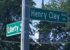
Park Heights is an area of Baltimore City, Maryland, that lies approximately 10 miles northwest of downtown Baltimore and within two miles of the Baltimore County line. A 1,500-acre community, Park Heights comprises 12 smaller neighborhoods that together contain approximately 30,000 residents. It is bounded on the south by Druid Park Drive, on the west by Wabash Avenue, on the east by Greenspring Avenue, and on the north by Northern Parkway. Interstate-83 is less than a half mile to the east. Two major roadways—Park Heights Avenue and Reisterstown Road—run north-south through Park Heights, serving as the neighborhood's "Main Streets" as well as commuter corridors. Limited commercial uses—primarily retail—are scattered along these roads; there is also some industrial activity on the neighborhood's western edge.

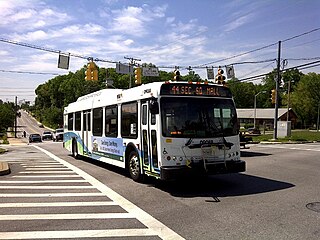
Maryland Route 129 is a state highway in the U.S. state of Maryland, running north-northwesterly from U.S. Route 40 and MD 295 in Baltimore into Baltimore County, ending at Garrison Forest Road east of Reisterstown. The route leaves downtown on the one-way pair of McCulloh Street and Druid Hill Avenue, and then uses the entire length of Park Heights Avenue to the end. MD 129 connects Downtown Baltimore with Druid Hill Park using McCulloh Street and Druid Hill Avenue. As Park Heights Avenue, the state highway is one of two primary radial routes in the northwestern part of the city, providing access to The Maryland Zoo and Pimlico Race Course. In Baltimore County, MD 129 passes through Pikesville, where it has a junction with Interstate 695 (I-695) and serves an affluent rural area north of Pikesville and east of Reisterstown.

Forest Park is a region of Northwest Baltimore, Maryland located west of Reisterstown Road, south of Northern Parkway, and east of the Baltimore City/County line. In Baltimore, the region is referred to by locals simply as "Forest Park" and includes the neighborhoods of Ashburton, Callaway-Garrison, Central Forest Park, Dolfield, Dorchester, East Arlington, Forest Park, Grove Park, Hanlon Longwood, Howard Park, Garwyn Oaks, Purnell, West Arlington, West Forest Park, and Windsor Hills.
Baltimore City Council's 1st District is a council district located in Southeast Baltimore, Maryland.
Fallstaff is a neighborhood in the Upper Park Heights area of Northwest Baltimore, Maryland, and is one of the city's northwesternmost communities. The area, which is mostly middle class, is part of the center of Baltimore's Orthodox Jewish community, and also has a heavy African-American and immigrant population.

Medfield is a neighborhood located in north Baltimore, Maryland, United States of America. It is located to the north of the trendy Hampden neighborhood and south of affluent Roland Park neighborhood. Its unofficial boundaries are Coldspring Lane to the north; Jones Falls Expressway to the west; Falls Road/Hickory Avenue to the east; and West 41st Street to the south.
O'Donnell is a surname, and an ancient and powerful Irish family.

"Mount Winans" is a mixed-use residential, commercial and industrial neighborhood in the southwestern area of the City of Baltimore in Maryland. Its north, south and east boundaries are marked by the various lines of track of the CSX Railroad. In addition, Hollins Ferry Road running to the south towards suburban Baltimore County in the southwest and further connecting with adjacent Anne Arundel County to the southeast, draws its western boundary.
Frankford is a neighborhood in northeast Baltimore. Frankford is the most populous of the city's designated neighborhoods, with over 17,000 residents.
Liberty Heights is a neighborhood in southeastern Lexington, Kentucky, United States. Its boundaries are Winchester Road to the north, New Circle Road to the east, and R. J. Corman railroad tracks to the west and south.
Edgecomb, also known as Parklane, is a neighborhood in the North District of Baltimore, located between the neighborhoods of Cylburn (north) and Greenspring (south). Its boundaries are marked by Dupont Avenue (north), Coldspring Lane (south), Pimlico Road (west) and Greenspring Avenue (east). Central Park Heights, is located on the opposite side of Pimlico Road in the Northwest District. The neighborhood of Coldspring is located to Edgecomb's east, across Greenspring Avenue.
Greenspring is a neighborhood in the North District of Baltimore, located between the neighborhoods of Woodberry (east) and Central Park Heights (west). Its boundaries are marked by West Cold Spring Lane (north), Greenspring Avenue (east), and Springhill Avenue (south). The western edge of the neighborhood runs along Pimlico Road from West Cold Spring Lane to Park Heights Avenue, then along Park Heights Avenue to Springhill Avenue.
Madison Park is a neighborhood in west Baltimore.
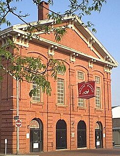
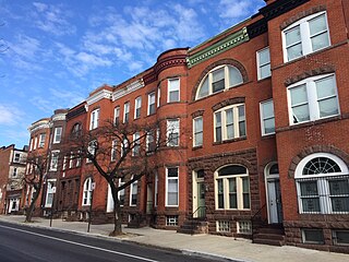
Hollins Market is a neighborhood in the Sowebo area of Baltimore. It takes its name from the Hollins Market, the oldest public market building still in use in Baltimore City, which is located in the heart of the neighborhood.
Levindale is a neighborhood in northwest Baltimore which includes Sinai Hospital, the Levindale Hebrew Geriatric Center and Hospital, and a small number of detached homes and apartment buildings towards its south.

