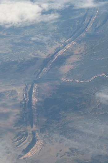
Erosion is the action of surface processes that removes soil, rock, or dissolved material from one location on the Earth's crust and then transports it to another location where it is deposited. Erosion is distinct from weathering which involves no movement. Removal of rock or soil as clastic sediment is referred to as physical or mechanical erosion; this contrasts with chemical erosion, where soil or rock material is removed from an area by dissolution. Eroded sediment or solutes may be transported just a few millimetres, or for thousands of kilometres.

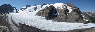
A glacier is a persistent body of dense ice that is constantly moving under its own weight. A glacier forms where the accumulation of snow exceeds its ablation over many years, often centuries. It acquires distinguishing features, such as crevasses and seracs, as it slowly flows and deforms under stresses induced by its weight. As it moves, it abrades rock and debris from its substrate to create landforms such as cirques, moraines, or fjords. Although a glacier may flow into a body of water, it forms only on land and is distinct from the much thinner sea ice and lake ice that form on the surface of bodies of water.

A valley is an elongated low area often running between hills or mountains, which will typically contain a river or stream running from one end to the other. Most valleys are formed by erosion of the land surface by rivers or streams over a very long period. Some valleys are formed through erosion by glacial ice. These glaciers may remain present in valleys in high mountains or polar areas.

A mountain is an elevated portion of the Earth's crust, generally with steep sides that show significant exposed bedrock. Although definitions vary, a mountain may differ from a plateau in having a limited summit area, and is usually higher than a hill, typically rising at least 300 metres (980 ft) above the surrounding land. A few mountains are isolated summits, but most occur in mountain ranges.

In physical geography, a fjord or fiord is a long, narrow sea inlet with steep sides or cliffs, created by a glacier. Fjords exist on the coasts of Antarctica, the Arctic, and surrounded landmasses of the northern and southern hemispheres. Norway's coastline is estimated to be 29,000 km (18,000 mi) long with its nearly 1,200 fjords, but only 2,500 km (1,600 mi) long excluding the fjords.

The cryosphere is an all-encompassing term for the portions of Earth's surface where water is in solid form, including sea ice, lake ice, river ice, snow cover, glaciers, ice caps, ice sheets, and frozen ground. Thus, there is a wide overlap with the hydrosphere. The cryosphere is an integral part of the global climate system with important linkages and feedbacks generated through its influence on surface energy and moisture fluxes, clouds, precipitation, hydrology, atmospheric and oceanic circulation.
Landforms are categorized by characteristic physical attributes such as their creating process, shape, elevation, slope, orientation, rock exposure, and soil type.
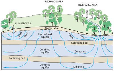
An underwater environment is a environment of, and immersed in, liquid water in a natural or artificial feature, such as an ocean, sea, lake, pond, reservoir, river, canal, or aquifer. Some characteristics of the underwater environment are universal, but many depend on the local situation.

An endorheic basin is a drainage basin that normally retains water and allows no outflow to other, external bodies of water ; instead, the water drainage flows into permanent and seasonal lakes and swamps that equilibrate through evaporation. Endorheic basins also are called closed basins, terminal basins, and internal drainage systems.

The Tibetan Plateau, also known as the Qinghai–Tibet Plateau or the Qing–Zang Plateau or as the Himalayan Plateau in India, is a vast elevated plateau located at the intersection of Central, South, and East Asia covering most of the Tibet Autonomous Region, most of Qinghai, western half of Sichuan, Southern Gansu provinces in Western China, southern Xinjiang, Bhutan, the Indian regions of Ladakh and Lahaul and Spiti as well as Gilgit-Baltistan in Pakistan, northwestern Nepal, eastern Tajikistan and southern Kyrgyzstan. It stretches approximately 1,000 kilometres (620 mi) north to south and 2,500 kilometres (1,600 mi) east to west. It is the world's highest and largest plateau above sea level, with an area of 2,500,000 square kilometres (970,000 sq mi). With an average elevation exceeding 4,500 metres (14,800 ft) and being surrounded by imposing mountain ranges that harbor the world's two highest summits, Mount Everest and K2, the Tibetan Plateau is often referred to as "the Roof of the World".

In geology and physical geography, a plateau, also called a high plain or a tableland, is an area of a highland consisting of flat terrain that is raised sharply above the surrounding area on at least one side. Often one or more sides have deep hills or escarpments. Plateaus can be formed by a number of processes, including upwelling of volcanic magma, extrusion of lava, and erosion by water and glaciers. Plateaus are classified according to their surrounding environment as intermontane, piedmont, or continental. A few plateaus may have a small flat top while others have wider ones.

The Driftless Area, also known as Bluff Country and the Paleozoic Plateau, is a topographical and cultural region in the Midwestern United States that comprises southwestern Wisconsin, southeastern Minnesota, northeastern Iowa, and the extreme northwestern corner of Illinois. The Driftless Area is a USDA Level III Ecoregion: Ecoregion 52. The Driftless Area takes up a large portion of the Upper Midwest forest–savanna transition. The Blufflands refers to the eastern section of the Driftless area in Minnesota, due to the steep bluffs and cliffs around the river valleys. The western half is known as the Rochester Plateau, which is flatter than the Blufflands. The Coulee Region refers to the southwestern part of the Driftless Area in Wisconsin. It is named for its numerous ravines.

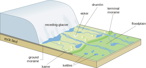
Glacial landforms are landforms created by the action of glaciers. Most of today's glacial landforms were created by the movement of large ice sheets during the Quaternary glaciations. Some areas, like Fennoscandia and the southern Andes, have extensive occurrences of glacial landforms; other areas, such as the Sahara, display rare and very old fossil glacial landforms.
In geomorphology, a knickpoint or nickpoint is part of a river or channel where there is a sharp change in channel bed slope, such as a waterfall or lake. Knickpoints reflect different conditions and processes on the river, often caused by previous erosion due to glaciation or variance in lithology. In the cycle of erosion model, knickpoints advance one cycle upstream, or inland, replacing an older cycle. A knickpoint that occurs at the head of a channel is called a headcut. Headcuts resulting in headward erosion are hallmarks of unstable expanding drainage features such as actively eroding gullies.

Glacier morphology, or the form a glacier takes, is influenced by temperature, precipitation, topography, and other factors. The goal of glacial morphology is to gain a better understanding of glaciated landscapes and the way they are shaped. Types of glaciers can range from massive ice sheets, such as the Greenland ice sheet, to small cirque glaciers found perched on mountain tops. Glaciers can be grouped into two main categories:
Blue Glacier is a large glacier located to the north of Mount Olympus in the Olympic Mountains of Washington. The glacier covers an area of 1.7 sq mi (4.4 km2) and contains 580,000,000 cu ft (16,000,000 m3) of ice and snow in spite of its low terminus elevation. The glacier length has decreased from about 3.4 mi (5.5 km) in 1800 to 2.7 mi (4.3 km) in the year 2000. Just in the period from 1995 and 2006, Blue Glacier retreated 325 ft (99 m). Blue Glacier is also thinning as it retreats and between 1987 and 2009 the glacier lost 178 ft (54 m) of its depth near its terminus and between 32 and 48 ft in the uppermost sections of the glacier known as the accumulation zone.

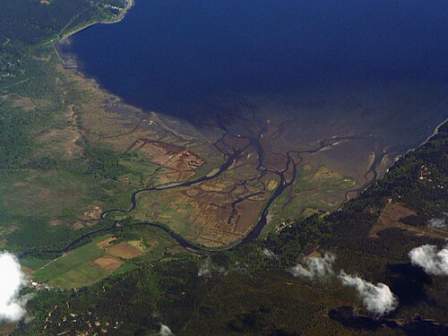
A river is a natural flowing watercourse, usually a freshwater stream, flowing on the earth's land surface or inside caves towards another waterbody at a lower elevation, such as an ocean, sea, bay, lake, wetland, or another river. In some cases, a river flows into the ground or becomes dry at the end of its course without reaching another body of water. Small rivers can be referred to by names such as creek, brook, and rivulet. There are no official definitions for the generic term river as applied to geographic features, although in some countries or communities, a stream is defined by its size. Many names for small rivers are specific to geographic location; examples are "run" in some parts of the United States, "burn" in Scotland and Northeast England, and "beck" in Northern England. Sometimes a river is defined as being larger than a creek, but not always; the language is vague.

The following outline is provided as an overview of and topical guide to geography:

This glossary of meteorology is a list of terms and concepts relevant to meteorology and atmospheric science, their sub-disciplines, and related fields.
This glossary of geography terms is a list of definitions of terms and concepts used in geography and related fields, including Earth science, oceanography, cartography, and human geography, as well as those describing spatial dimension, topographical features, natural resources, and the collection, analysis, and visualization of geographic data. It is split across two articles: