Gore, Oklahoma

Last updated

Gore, Oklahoma
OKMap-doton-Gore.PNG
Location of Gore, Oklahoma
Coordinates: 35°32′30″N95°06′47″W / 35.54167°N 95.11306°W / 35.54167; -95.11306
Country United States
State Oklahoma
County Sequoyah
Area
[1]
  Total2.29 sq mi (5.92 km2)
  Land2.28 sq mi (5.91 km2)
  Water0.00 sq mi (0.01 km2)
Elevation
[2]
535 ft (163 m)
Population
 (2020)
  Total951
  Density416.56/sq mi (160.83/km2)
Time zone UTC-6 (Central (CST))
  Summer (DST) UTC-5 (CDT)
ZIP code
74435
Area code(s) 539/918
FIPS code 40-30300 [3]
GNIS feature ID2412692 [2]
Websitewww.townofgore.org

Gore is a town in western Sequoyah County, Oklahoma, United States. It is part of the Fort Smith, Arkansas-Oklahoma Metropolitan Statistical Area. The population was 977 at the 2010 census, an increase of 15 percent over the figure of 850 recorded in 2000. [4]

Contents

Gore claims to be the "trout capital of Oklahoma", with great fishing in Lake Tenkiller, the Illinois River, and the Arkansas River. [5]

History

This community began as a small settlement in Indian Territory known as Campbell, named for Dr. W. W. Campbell, who, along with Joe Lynch, operated a ferry across the Arkansas River between Campbell and Webbers Falls. Tahlonteskee, the capital of the Western Cherokee from 1828–1839, was near here, just two miles to the north of town. [lower-alpha 1] In 1829, John Jolly, chief of the Cherokee Nation–West, built a home in this area.

The settlement was also known as Illinois Station or "Illinois Station, Campbell Post Office." It became a stage stop on the route between Fort Gibson and Fort Smith. A post office designation of Campbell was assigned to Dr. Campbell's store in 1888. Also in 1888, the St. Louis, Iron Mountain and Southern Railway (later the Missouri Pacific Railway) built a rail line through the settlement. [6]

By 1909, the town had a bank, two lumber companies, a flour mill, a cotton gin, two hotels, and numerous retail outlets. The town changed its name on October 22, 1909, in honor of Oklahoma Senator Thomas Gore, who was serving as one of Oklahoma's U. S. senators immediately after statehood. A fire destroyed most of the business district in 1909. Gore had a population of 319 by the 1910 U. S. census. [6]

The town almost got a second rail line in 1917 when Congress approved construction by the Webbers Falls Railroad of a bridge over the Arkansas from Webbers Falls. [7] However, that railroad was instead scrapped in 1918. [8]

Kerr-McGee built the Sequoyah Fuels Corporation uranium mill on a 300 acres (120 ha) tract located 3 miles (4.8 km) east of Gore to convert uranium ore into uranium hexafluoride (UF6). [lower-alpha 2] The UF6 plant was bought by General Atomics in 1988, and closed in 1993. [6]

Demographics

Historical population
CensusPop.Note
1910 316
1920 3294.1%
1930 297−9.7%
1940 33412.5%
1950 38715.9%
1960 334−13.7%
1970 47843.1%
1980 445−6.9%
1990 69055.1%
2000 85023.2%
2010 97714.9%
2020 951−2.7%
U.S. Decennial Census [9]

As of the census [3] of 2000, there were 850 people, 368 households, and 257 families residing in the town. The population density was 372.4 inhabitants per square mile (143.8/km2). There were 416 housing units at an average density of 182.3 per square mile (70.4/km2). The racial makeup of the town was 68.59% White, 0.12% African American, 24.71% Native American, 0.12% from other races, and 6.47% from two or more races. Hispanic or Latino of any race were 0.82% of the population.

There were 368 households, out of which 28.5% had children under the age of 18 living with them, 56.0% were married couples living together, 12.0% had a female householder with no husband present, and 29.9% were non-families. 26.9% of all households were made up of individuals, and 12.0% had someone living alone who was 65 years of age or older. The average household size was 2.31 and the average family size was 2.78.

In the town, the population was spread out, with 23.9% under the age of 18, 8.8% from 18 to 24, 21.9% from 25 to 44, 26.9% from 45 to 64, and 18.5% who were 65 years of age or older. The median age was 42 years. For every 100 females, there were 89.3 males. For every 100 females age 18 and over, there were 81.7 males.

The median income for a household in the town was $27,266, and the median income for a family was $37,000. Males had a median income of $28,125 versus $27,188 for females. The per capita income for the town was $16,059. About 15.2% of families and 16.6% of the population were below the poverty line, including 18.2% of those under age 18 and 21.1% of those age 65 or over.

Notable people

Notes

  1. After the Eastern Cherokee were relocated to Indian Territory and united with the Western Cherokees, Talequah became the Cherokee capital. Thereafter, Tahlonteskee became the courthouse of the Illinois District of the Cherokee Nation until 1846. [6]
  2. The product was shipped to another plant near Oklahoma City, where it was used to make fuel rods for nuclear reactors. [6]

Related Research Articles

<span class="mw-page-title-main">Sequoyah County, Oklahoma</span> County in Oklahoma, United States

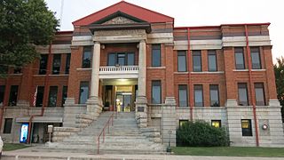
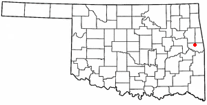
Sequoyah County is a county located in the U.S. state of Oklahoma. As of the 2020 census, the population was 39,281. The county seat is Sallisaw. Sequoyah County was created in 1907 when Oklahoma became a state. It was named after Sequoyah, who created the Cherokee syllabary and its written language.

<span class="mw-page-title-main">Muskogee County, Oklahoma</span> County in Oklahoma, United States

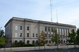
Muskogee County is a county located in the U.S. state of Oklahoma. As of the 2020 census, the population was 66,339. The county seat is Muskogee. The county and city were named for the Muscogee (Creek) Nation. The official spelling of the name was changed to Muskogee by the post office in 1900.

<span class="mw-page-title-main">Adair County, Oklahoma</span> County in Oklahoma, United States

Adair County is a county located in the U.S. state of Oklahoma. As of the 2020 census, the population was 19,495. Its county seat is Stilwell. Adair County was named after the Adair family of the Cherokee tribe. One source says that the county was specifically named for Watt Adair, one of the first Cherokees to settle in the area. Adair County is part of the Cherokee Nation reservation.

<span class="mw-page-title-main">Crawford County, Arkansas</span> County in Arkansas, United States

Crawford County is a county located in the Ozarks region of the U.S. state of Arkansas. As of the 2020 census, the population was 60,133. The county seat and largest city is Van Buren. Crawford County was formed on October 18, 1820, from the former Lovely County and Indian Territory, and was named for William H. Crawford, the United States Secretary of War in 1815.

<span class="mw-page-title-main">Westville, Oklahoma</span> Township in Oklahoma, United States

Westville is a town in Adair County, Oklahoma, located in the foothills of the Ozark Mountains. Westville lies at the junction of U.S. Highways 59 and 62, and approximately 13 miles north of Stilwell, the county seat.

<span class="mw-page-title-main">West Siloam Springs, Oklahoma</span> Town in Oklahoma, United States

West Siloam Springs is a town in Delaware County, Oklahoma, United States. The population was 1,000 at the 2020 census, an 18.2 percent increase from the figure of 846 recorded in 2010. A bedroom community for Siloam Springs, Arkansas, it is notable for its Cherokee casino, and is the closest town to Natural Falls State Park.

<span class="mw-page-title-main">Warner, Oklahoma</span> Town in Muskogee County, Oklahoma, United States

Warner is a town in Muskogee County, Oklahoma, United States. The population was 1,641 at the 2010 census, an increase of 14.8 percent over the figure of 1,430 recorded in 2000. The town is home to one of the two Connors State College campuses.

<span class="mw-page-title-main">Webbers Falls, Oklahoma</span> Town in Oklahoma, United States

Webbers Falls is a town in southeastern Muskogee County, Oklahoma, United States. The population was 616 at the 2010 census, a decline of 14.9 percent from the figure of 724 recorded in 2000.

<span class="mw-page-title-main">Morrison, Oklahoma</span> Town in Oklahoma, United States

Morrison is a town in southeastern Noble County, Oklahoma, United States. The population was 733 at the 2010 census, an increase from the figure of 636 in 2000.

<span class="mw-page-title-main">Nowata, Oklahoma</span> City in Oklahoma, United States

Nowata is a city and county seat of Nowata County, Oklahoma, United States. The population was 3,731 at the United States Census, 2010, a 6.0 percent decline from the figure of 3,971 recorded in 2000. The area where it was established was then part of the Cherokee Nation in Indian Territory.

Dwight Mission is a census-designated place (CDP) in Sequoyah County, Oklahoma, United States. It is part of the Fort Smith, Arkansas-Oklahoma Metropolitan Statistical Area. The population was 55 at the 2010 census, a 71.9 percent gain over the figure of 32 recorded in 2000. It is currently the home of Dwight Mission Presbyterian Camp & Retreat Center.

<span class="mw-page-title-main">Gans, Oklahoma</span> Town in Oklahoma, United States

Gans is a town in Sequoyah County, Oklahoma, United States. It is part of the Fort Smith, Arkansas-Oklahoma Metropolitan Statistical Area. The population was 312 at the 2010 census, an increase of 50 percent over the figure of 208 recorded in 2000.

<span class="mw-page-title-main">Long, Oklahoma</span> CDP in Oklahoma, United States

Long is a census-designated place (CDP) in Sequoyah County, Oklahoma, United States. It is part of the Fort Smith, Arkansas-Oklahoma Metropolitan Statistical Area. The population was 363 at the 2000 census.

<span class="mw-page-title-main">Marble City, Oklahoma</span> Town in Oklahoma, United States

Town of Marble City is a town in Sequoyah County, Oklahoma, United States. It is part of the Fort Smith, Arkansas-Oklahoma Metropolitan Statistical Area. The population was 263 at the 2010 census, an increase of 8.7 percent over the figure of 242 recorded in 2000, making it the seventh-largest town by population in Sequoyah County, after Gans and before Moffett.

<span class="mw-page-title-main">Moffett, Oklahoma</span> Town in Oklahoma, United States

Moffett is a town in Sequoyah County, Oklahoma, United States. It is part of the Fort Smith, Arkansas-Oklahoma Metropolitan Statistical Area. The population was 128 at the 2010 census, a decline of 28.5 percent from the figure of 179 recorded in 2000.

<span class="mw-page-title-main">Muldrow, Oklahoma</span> Town in Oklahoma, United States

Muldrow, officially the Town of Muldrow, is a town in Sequoyah County, Oklahoma, United States. It is part of the Fort Smith, Arkansas–Oklahoma Metropolitan Statistical Area. The population was 3,466 at the 2010 census, an increase of 11.7 percent over the figure of 3,104 recorded in 2000.

Redbird Smith is a census-designated place (CDP) in Sequoyah County, Oklahoma, United States. It is part of the Fort Smith, Arkansas-Oklahoma Metropolitan Statistical Area. The population was 411 at the 2000 census. It was named for Redbird Smith (Cherokee), who founded the Keetoowah Nighthawk Society in Indian Territory and established a ceremonial ground here for sacred rituals.

<span class="mw-page-title-main">Roland, Oklahoma</span> Town in Oklahoma, United States

Roland is a town in Sequoyah County, Oklahoma, United States. It is part of the Fort Smith, Arkansas-Oklahoma Metropolitan Statistical Area. The population was 3,169 at the 2010 census, compared to the figure of 2,842 recorded in 2000.

<span class="mw-page-title-main">Sallisaw, Oklahoma</span> City in Oklahoma, United States

Sallisaw is a city and county seat in Sequoyah County, Oklahoma, United States. As of the 2010 Census, it had a population of 8,880, an 11.2 percent increase over the figure of 7,891 recorded in 2000. Sallisaw is part of the Fort Smith, Arkansas–Oklahoma Metropolitan Statistical Area.

<span class="mw-page-title-main">Vian, Oklahoma</span> Town in Oklahoma, United States

Vian is a town in Sequoyah County, Oklahoma, United States, adjacent to Interstate 40 at the intersection of U.S. Route 64 and Oklahoma State Highway 82. The population was 1,374 at the 2020 census, a 6.3 percent decline from the figure of 1,466 recorded in 2010. It is part of the Fort Smith Metropolitan Statistical Area.

References

  1. "ArcGIS REST Services Directory". United States Census Bureau. Retrieved September 20, 2022.
  2. 1 2 U.S. Geological Survey Geographic Names Information System: Gore, Oklahoma
  3. 1 2 "U.S. Census website". United States Census Bureau . Retrieved January 31, 2008.
  4. Census Viewer: Population of the City of Gore, Oklahoma. Retrieved April 3, 2012 Archived June 15, 2013, at the Wayback Machine
  5. Gore, Oklahoma Archived March 4, 2016, at the Wayback Machine Accessed March 18, 2015.
  6. 1 2 3 4 5 Larry O'Dell, "Gore". Encyclopedia of Oklahoma History and Culture. Retrieved April 3, 2012.
  7. "Webbers Falls Railroad". 1917. Retrieved September 26, 2022.
  8. "Buying Whole Railroads and Reducing Them to Junk". Current Opinion, Volume 65, p.274-275, October 1918. 1918. Retrieved September 26, 2022.
  9. "Census of Population and Housing". Census.gov. Retrieved June 4, 2015.
  10. "Resume aside, Rowe focused on next job", Portland Press-Herald , May 13, 2010.