Hardeman County | |
---|---|
Coordinates: 35°12′N89°00′W / 35.2°N 89°W | |
Country | United States |
State | Tennessee |
Founded | 1823 |
Named for | Thomas J. Hardeman [1] |
Seat | Bolivar |
Largest city | Bolivar |
Area | |
• Total | 670 sq mi (1,700 km2) |
• Land | 668 sq mi (1,730 km2) |
• Water | 2.6 sq mi (7 km2) 0.4% |
Population (2020) | |
• Total | 25,462 |
• Density | 41/sq mi (16/km2) |
Time zone | UTC−6 (Central) |
• Summer (DST) | UTC−5 (CDT) |
Congressional district | 8th |
Hardeman County is a county located in the U.S. state of Tennessee. As of the 2020 census, the population was 25,462. [2] Its county seat is Bolivar. [3]
Hardeman County was created by the Tennessee General Assembly in 1823 from parts of Hardin County and "Indian lands." It is named for Thomas J. Hardeman [4] (1788-1854), a veteran of the Creek War and the War of 1812 and a prominent figure in the fight for Texas independence. He served as a congressman in the Republic of Texas. [1]
Settlers began arriving in the area that is now Hardeman County in 1819, following a treaty with the Chickasaw allowing settlement in West Tennessee signed on October 19, 1818. [5] Among these earliest settlers were the county's namesame Thomas Hardeman and Ezekiel Polk, the paternal grandfather of president James K. Polk. [6] Thereafter, further settlers arrived from Middle Tennessee, Alabama, North and South Carolina, and Virginia. [5]
The first permanent settlement was established in 1823 along the Hatchie River, dubbed Hatchie Town. The town's location along the river led to recurrent flooding, and ultimately the decision was made to relocate the settlement approximately one mile south to what is now Bolivar. [5] [6]
Hardeman County had notable involvement in the Civil War. The Battle of Hatchie's Bridge took place there on October 5, 1862, seeing 900 total casualties. During the war, the Union Army maintained control of the municipality of Grand Junction. The town was thus made a contraband camp by General Ulysses S. Grant, providing education and shelter to formerly enslaved individuals. [5] [6] Relating to these engagements, much of downtown Bolivar was burned down during the war. [5] [6]
The county is the location of two of Tennessee's four private prisons, the Whiteville Correctional Facility and the Hardeman County Correctional Center. Both are medium-security facilities for men, operated by the Corrections Corporation of America. [7] [8]
According to the U.S. Census Bureau, the county has a total area of 670 square miles (1,700 km2), of which 668 square miles (1,730 km2) is land and 2.6 square miles (6.7 km2) (0.4%) is water. [9] It is the fifth-largest county in Tennessee by area.
Census | Pop. | Note | %± |
---|---|---|---|
1830 | 11,655 | — | |
1840 | 14,563 | 25.0% | |
1850 | 17,456 | 19.9% | |
1860 | 17,769 | 1.8% | |
1870 | 18,074 | 1.7% | |
1880 | 22,921 | 26.8% | |
1890 | 21,029 | −8.3% | |
1900 | 22,976 | 9.3% | |
1910 | 23,011 | 0.2% | |
1920 | 22,278 | −3.2% | |
1930 | 22,193 | −0.4% | |
1940 | 23,590 | 6.3% | |
1950 | 23,311 | −1.2% | |
1960 | 21,517 | −7.7% | |
1970 | 22,435 | 4.3% | |
1980 | 23,873 | 6.4% | |
1990 | 23,377 | −2.1% | |
2000 | 28,105 | 20.2% | |
2010 | 27,253 | −3.0% | |
2020 | 25,462 | −6.6% | |
U.S. Decennial Census [10] 1790-1960 [11] 1900-1990 [12] 1990-2000 [13] 2010-2014 [2] |
Race / Ethnicity (NH = Non-Hispanic) | Pop 2000 [15] | Pop 2010 [16] | Pop 2020 [17] | % 20010 | % 2010 | % 2020 |
---|---|---|---|---|---|---|
White alone (NH) | 15,994 | 15,197 | 13,970 | 56.91% | 55.76% | 54.87% |
Black or African American alone (NH) | 11,474 | 11,228 | 10,150 | 40.83% | 41.20% | 39.86% |
Native American or Alaska Native alone (NH) | 66 | 56 | 46 | 0.23% | 0.21% | 0.18% |
Asian alone (NH) | 78 | 145 | 162 | 0.28% | 0.53% | 0.64% |
Pacific Islander alone (NH) | 5 | 0 | 6 | 0.02% | 0.00% | 0.02% |
Some Other Race alone (NH) | 13 | 18 | 68 | 0.05% | 0.07% | 0.27% |
Mixed Race or Multi-Racial (NH) | 202 | 233 | 566 | 0.72% | 0.85% | 2.22% |
Hispanic or Latino (any race) | 273 | 376 | 494 | 0.97% | 1.38% | 1.94% |
Total | 28,105 | 27,253 | 25,462 | 100.00% | 100.00% | 100.00% |
As of the 2020 United States census, there were 25,462 people, 8,891 households, and 5,816 families residing in the county.
As of the census [18] of 2010 the racial makeup of the county was 56.1% White (non-Hispanic) or European American, 41.01% Black or African American, 0.24% Native American, 0.29% Asian, 0.01% Pacific Islander, 0.2% from other races, and 0.79% from two or more races. 0.96% of the population were Hispanic or Latino of any race.
As of the census [18] of 2000, there were 28,105 people, 9,412 households, and 6,767 families residing in the county. The population density was 42 people per square mile (16 people/km2). There were 10,694 housing units at an average density of 16 units per square mile (6.2/km2). The racial makeup of the county was 57.34% White (non-Hispanic) or European American, 40.97% Black or African American, 0.26% Native American, 0.31% Asian, 0.02% Pacific Islander, 0.30% from other races, and 0.79% from two or more races. 0.97% of the population were Hispanic or Latino of any race.
There were 9,412 households, out of which 32.60% had children under the age of 18 living with them, 50.00% were married couples living together, 17.60% had a female householder with no husband present, and 28.10% were non-families. 25.10% of all households were made up of individuals, and 11.40% had someone living alone who was 65 years of age or older. The average household size was 2.56 and the average family size was 3.06.
In the county, the population was spread out, with 23.90% under the age of 18, 9.80% from 18 to 24, 31.30% from 25 to 44, 22.40% from 45 to 64, and 12.60% who were 65 years of age or older. The median age was 36 years. For every 100 females there were 116.90 males. For every 100 females age 18 and over, there were 121.40 males.
The median income for a household in the county was $29,111, and the median income for a family was $34,746. Males had a median income of $27,828 versus $20,759 for females. The per capita income for the county was $13,349. About 16.90% of families and 19.70% of the population were below the poverty line, including 24.40% of those under age 18 and 20.80% of those age 65 or over.
Apart from its powerful vote against Hubert Humphrey in 1968 and George McGovern in 1972 as well as George H. W. Bush's 21-vote plurality in 1988, Hardeman County was a solidly Democratic county up until it flipped to Donald Trump in 2016.
Year | Republican | Democratic | Third party | |||
---|---|---|---|---|---|---|
No. | % | No. | % | No. | % | |
2020 | 5,760 | 57.24% | 4,180 | 41.54% | 123 | 1.22% |
2016 | 4,919 | 53.05% | 4,185 | 45.13% | 169 | 1.82% |
2012 | 4,865 | 46.60% | 5,482 | 52.51% | 92 | 0.88% |
2008 | 5,225 | 46.50% | 5,919 | 52.67% | 93 | 0.83% |
2004 | 4,704 | 44.95% | 5,685 | 54.32% | 77 | 0.74% |
2000 | 3,729 | 42.36% | 4,953 | 56.26% | 121 | 1.37% |
1996 | 2,961 | 35.97% | 4,859 | 59.03% | 411 | 4.99% |
1992 | 3,122 | 36.19% | 4,832 | 56.01% | 673 | 7.80% |
1988 | 3,547 | 49.69% | 3,526 | 49.40% | 65 | 0.91% |
1984 | 3,712 | 48.68% | 3,797 | 49.79% | 117 | 1.53% |
1980 | 2,931 | 40.68% | 4,153 | 57.64% | 121 | 1.68% |
1976 | 2,254 | 35.95% | 3,934 | 62.74% | 82 | 1.31% |
1972 | 3,494 | 66.00% | 1,550 | 29.28% | 250 | 4.72% |
1968 | 1,171 | 20.18% | 1,709 | 29.45% | 2,924 | 50.38% |
1964 | 2,450 | 47.80% | 2,675 | 52.20% | 0 | 0.00% |
1960 | 1,601 | 44.42% | 1,711 | 47.48% | 292 | 8.10% |
1956 | 818 | 24.40% | 1,754 | 52.31% | 781 | 23.29% |
1952 | 1,256 | 31.17% | 2,747 | 68.18% | 26 | 0.65% |
1948 | 317 | 9.61% | 1,609 | 48.76% | 1,374 | 41.64% |
1944 | 444 | 18.50% | 1,949 | 81.21% | 7 | 0.29% |
1940 | 319 | 11.10% | 2,549 | 88.66% | 7 | 0.24% |
1936 | 157 | 7.74% | 1,869 | 92.11% | 3 | 0.15% |
1932 | 281 | 10.49% | 2,377 | 88.69% | 22 | 0.82% |
1928 | 491 | 25.04% | 1,453 | 74.09% | 17 | 0.87% |
1924 | 254 | 13.39% | 1,586 | 83.61% | 57 | 3.00% |
1920 | 895 | 28.59% | 2,212 | 70.67% | 23 | 0.73% |
1916 | 485 | 21.89% | 1,724 | 77.80% | 7 | 0.32% |
1912 | 320 | 16.71% | 1,323 | 69.09% | 272 | 14.20% |
Hardeman County is a county located in the U.S. state of Texas. As of the 2020 census, its population was 3,549. The county seat and largest city is Quanah. The county was created in 1858 and later organized in 1884. It is named for two brothers, Bailey Hardeman and Thomas Jones Hardeman, early Texas politicians and legislators. Hardeman County was one of 46 prohibition or entirely dry counties in the state of Texas until November 2006, when voters approved referendums to permit the legal sale of alcoholic beverages for on- and off-premises consumption.
Madison County is a county located in the western part of the U.S. state of Tennessee. As of the 2020 census, the population was 98,823. Its county seat is Jackson. Madison County is included in the Jackson, TN Metropolitan Statistical Area.
Chester County is a county located in the U.S. state of Tennessee. As of the 2020 census, the population was 17,341. Its county seat is Henderson. The county was created in 1879 and organized in 1882. Chester County is included in the Jackson, TN Metropolitan Statistical Area.
Saline County is located along the Missouri River in the U.S. state of Missouri. As of the 2020 census, the population was 23,333. Its county seat is Marshall. The county was established November 25, 1820, and named for the region's salt springs.
Polk County is a county located in the southwestern portion of the U.S. state of Missouri. As of the 2020 census, the population was 31,519. Its county seat is Bolivar. The county was organized January 5, 1835, and named for Ezekiel Polk.
Catoosa County is a county located in the northwestern part of the U.S. state of Georgia. As of the 2020 census, the population was 67,872. The county seat is Ringgold. The county was created on December 5, 1853. The meaning of the Cherokee language name "Catoosa" is obscure: "Catoosa" may come from the Cherokee words gatusi or gatu'gitse.
Sneads is a town in Jackson County, Florida, United States. The population was 1,849 at the 2020 census.
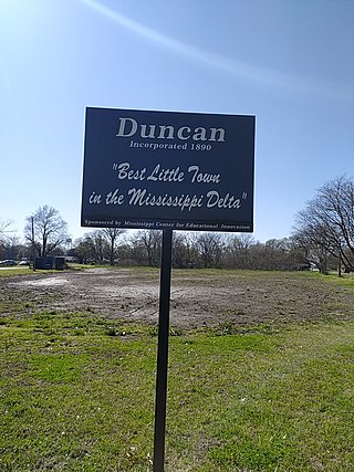
Duncan is a town in Bolivar County, Mississippi, United States. Per the 2020 census, the population was 276.
Gunnison is a town in Bolivar County, Mississippi, United States. Per the 2020 census, the population was 295.
Bolivar is a city and county seat of Polk County, Missouri, United States.
Humansville is a city in Polk County, Missouri, United States. As of the 2020 census, the city population was 965.
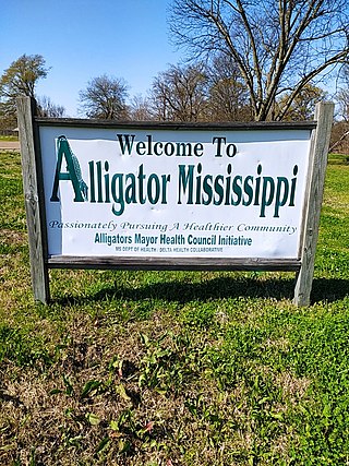
Alligator is a town in Bolivar County, Mississippi, United States. Per the 2020 Census, the population was 116.
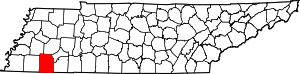
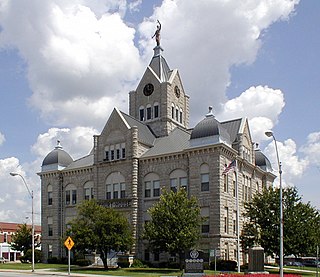
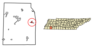
Bolivar is a city in and the county seat of Hardeman County, Tennessee, United States. The town was named for South American revolutionary leader Simón Bolívar. As of the 2010 census, the city population was 5,417.
Hornsby is a town in Hardeman County, Tennessee. The population was 303 at the 2010 census. The town is just east of Bolivar along U.S. Highway 64.
Middleton is a city in Hardeman County, Tennessee, United States. The population was 706 at the 2010 census, up from 602 at the 2000 census. It is located at the intersection of Tennessee State Route 125 and Tennessee State Route 57. Its slogan is the "Crossroads of the South".
Toone is a town in Hardeman County, Tennessee, United States. The population was 364 at the 2010 census.
Whiteville is a town in Hardeman County, Tennessee, United States. The population was 2,606 at the 2020 census and 4,638 at the 2010 census, Whiteville is the location of two privately owned prisons, Whiteville Correctional Facility and Hardeman County Correctional Center. Whiteville is also home to Allen-White School, a former Rosenwald school that was placed on the National Register of Historic Places in 2005.
Medon is a city in Madison County. It is included in the Jackson, Tennessee Metropolitan Statistical Area. The population was 178 at the 2010 census.
Mt. Juliet is a city located in western Wilson County, Tennessee, United States. A suburb of Nashville, it is approximately 17 miles (27 km) east of downtown Nashville. Mt. Juliet is located mostly between two major national east-west routes, Interstate 40 and U.S. Route 70. As of the 2020 United States census, Mount Juliet has a population of approximately 39,289 people. Mt. Juliet is the largest city in Wilson County. The official city charter has the name listed as Mt. Juliet; however, the United States Postal Service lists its name as Mount Juliet.
Grand Junction is a city between the border of Hardeman and Fayette County, Tennessee, United States. The population was 325 at the 2010 census, and was estimated to be 303 in 2015.