
Denver is the central city of a conurbation region in the U.S. state of Colorado. The conurbation includes one continuous region consisting of the six central counties of Adams, Arapahoe, Broomfield, Denver, Douglas, and Jefferson. The Denver region is part of the Front Range Urban Corridor.
In the United States, a metropolitan statistical area (MSA) is a geographical region with a relatively high population density at its core and close economic ties throughout the area. Such regions are neither legally incorporated as a city or town would be, nor are they legal administrative divisions like counties or separate entities such as states; because of this, the precise definition of any given metropolitan area can vary with the source. The statistical criteria for a standard metropolitan area were defined in 1949 and redefined as metropolitan statistical area in 1983.

The Louisville metropolitan area is the 43rd largest metropolitan statistical area (MSA) in the United States. It had a population of 1,395,855 in 2020 according to the latest official census, and its principal city is Louisville, Kentucky.
United States micropolitan statistical areas, as defined by the Office of Management and Budget (OMB), are labor market and statistical areas in the United States centered on an urban cluster with a population of at least 10,000 but fewer than 50,000 people. The micropolitan area designation was created in 2003. Like the better-known metropolitan statistical areas, a micropolitan area is a geographic entity used for statistical purposes based on counties and county equivalents. The OMB has identified 543 micropolitan areas in the United States.
Combined statistical area (CSA) is a United States Office of Management and Budget (OMB) term for a combination of adjacent metropolitan (MSA) and micropolitan statistical areas (µSA) across the 50 U.S. states and the territory of Puerto Rico that can demonstrate economic or social linkage. CSAs were first designated in 2003. The OMB defines a CSA as consisting of various combinations of adjacent metropolitan and micropolitan areas with economic ties measured by commuting patterns. These areas that combine retain their own designations as metropolitan or micropolitan statistical areas within the larger combined statistical area.
Pennsylvania has fourteen metropolitan statistical areas (MSAs) and four combined statistical areas (CSAs), as defined by the United States Census Bureau. A map of the Pennsylvania MSAs is available from the Census Bureau. As of 2020 Philadelphia is the seventh-largest United States metropolitan area.

The Lexington–Fayette metropolitan area is the 109th-largest metropolitan statistical area (MSA) in the United States. It was originally formed by the United States Census Bureau in 1950 and consisted solely of Fayette County until 1980 when surrounding counties saw increases in their population densities and the number of their residents employed within Lexington–Fayette, which led to them meeting Census criteria to be added to the MSA.

The Colorado Springs, CO, Metropolitan Statistical Area is a United States Office of Management and Budget defined Metropolitan Statistical Area (MSA) located in the Colorado Springs region of the State of Colorado. The 2020 United States census counted a population of 755,105, an increase of 17.0% since the 2010 United States Census. The Colorado Springs MSA is the 79th-most populous MSA in the United States. The Colorado Springs MSA encompasses El Paso County and Teller County, Colorado. Approximately 88.40% percent of the MSA's population live in cities or CDPs. The Colorado Springs Metropolitan Statistical Area is the second-most populous component of the Front Range Urban Corridor.
The United States Office of Management and Budget has defined the 12-county Denver–Aurora, CO Combined Statistical Area comprising the Denver–Aurora–Lakewood, CO Metropolitan Statistical Area, the Boulder, CO Metropolitan Statistical Area, and the Greeley, CO Metropolitan Statistical Area. The United States Census Bureau estimates that the population was 3,214,218 as of July 1, 2012, an increase of +3.99% since the 2010 United States Census, and ranking as the 16th most populous metropolitan combined statistical area and the 17th most populous primary statistical area of the United States. The population estimate for 2020 was 3,652,385.

The Cheyenne Metropolitan Statistical Area is a United States Census Bureau defined Metropolitan Statistical Area (MSA) located in the Cheyenne region of the State of Wyoming. The Cheyenne Metropolitan Statistical Area is defined as Laramie County, Wyoming. Many consider the Cheyenne Metro Area to be the economic hub of eastern Wyoming. The Census Bureau estimates that the population was 99,500 in 2019, ranking as the 288th most populous metropolitan area in the United States.
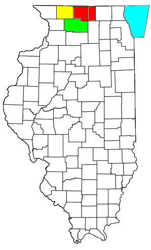
The Rockford Metropolitan Statistical Area, as defined by the United States Census Bureau, is an area consisting of four counties in north-central Illinois, anchored by the city of Rockford. As of the 2010 census, the MSA had a population of 349,431. The Rockford MSA abuts the southern portions of the Janesville-Beloit MSA and the Chicago MSA. It forms the main part of the larger Rockford–Freeport–Rochelle Combined Statistical Area.

The Montgomery, Alabama Metropolitan Statistical Area is a metropolitan area in central Alabama. As of 2020, the MSA had a population of 386,047, ranking it 142nd among United States Metropolitan Statistical Areas. That number is up +3.07% from the 2010 census number of 374,536. In September of 2018 the OMB formed the Montgomery-Selma-Alexander City CSA. It's made up of the 4 county Montgomery MSA and the Selma, AL and Alexander City, AL micropolitan areas. The 7 county CSA has a population of 522,873 as of the 2020 census.

The Huntsville Metropolitan Statistical Area is a metropolitan statistical area on the northern border of Alabama. The metro area's principal city is Huntsville, and consists of two counties: Limestone and Madison. As of the 2020 United States census, the Huntsville Metropolitan Area's population was 491,723, making it the 2nd-largest metropolitan area in Alabama and the 117th-largest in the United States.
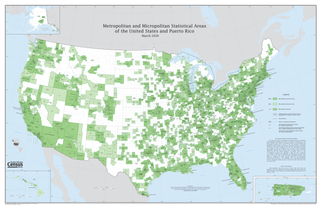
The United States federal government defines and delineates the nation's metropolitan areas for statistical purposes, using a set of standard statistical area definitions. As of 2020, the U.S. Office of Management and Budget (OMB) defined and delineated 392 metropolitan statistical areas (MSAs) and 547 micropolitan statistical areas (μSAs) in the United States and Puerto Rico. Many of these 939 MSAs and μSAs are, in turn, components of larger combined statistical areas (CSAs) consisting of adjacent MSAs and μSAs that are linked by commuting ties; as of 2020, 551 metropolitan and micropolitan areas are components of the 175 defined CSAs. A collective term for MSAs, μSAs, and CSAs is primary statistical areas (PSAs), though that term is not used by OMB.
This page is based on this
Wikipedia article Text is available under the
CC BY-SA 4.0 license; additional terms may apply.
Images, videos and audio are available under their respective licenses.


