Polk County, Tennessee

Last updated

Polk County
Polk-County-Courthouse-Benton-tn.jpg
Polk County Courthouse in Benton
Seal of Polk County, Tennessee.png
Map of Tennessee highlighting Polk County.svg
Location within the U.S. state of Tennessee
Tennessee in United States.svg
Tennessee's location within the U.S.
Coordinates: 35°08′N84°31′W / 35.13°N 84.52°W / 35.13; -84.52
CountryFlag of the United States.svg United States
StateFlag of Tennessee.svg  Tennessee
FoundedNovember 28, 1839
Named for James K. Polk [1]
Seat Benton
Largest townBenton
Area
  Total442 sq mi (1,140 km2)
  Land435 sq mi (1,130 km2)
  Water7.7 sq mi (20 km2)  1.7%
Population
 (2020)
  Total17,544 Increase2.svg
  Density40.33/sq mi (15.57/km2)
Time zone UTC−5 (Eastern)
  Summer (DST) UTC−4 (EDT)
Congressional district 3rd
Website www.polkgovernment.com

Polk County is a county located in the southeastern corner of the U.S. state of Tennessee. As of the 2020 United States census, its population was 17,544. [2] Its county seat is Benton. [3] The county was created on November 28, 1839, from parts of Bradley and McMinn counties, after final removal of most Cherokee from the region that year. The county was named after then-governor (and future president) James K. Polk. Polk County is included in the Cleveland, Tennessee Metropolitan Area Statistical Area, which is also included in the Chattanooga–Cleveland–Dalton, TN–GA–AL Combined Statistical Area.

Contents

History

Prior to the settlement of the Europeans, Polk County was inhabited by the Cherokee, and before them, thousands of years of indigenous cultures. The portion of Polk County north of the Hiwassee River was ceded by the Cherokee Nation to the US in the Calhoun Treaty of 1819. The rest of the county was part of the Ocoee District. The Cherokee were forcibly removed from here in 1838-1839 and taken to Indian Territory, in a passage that became known as the Trail of Tears. [1]

Polk County was created by an act of the Tennessee General Assembly on November 23, 1839. The location for the county seat of Benton was chosen by an election held on February 4, 1840. [1]

Copper was discovered in Ducktown in 1843. By the 1850s, a large mining operation was underway in southeastern Polk County; the area became known as the Copper Basin. This operation continued until 1987, when the last mine closed.

During the Civil War, Polk County was one of only six counties in East Tennessee to support the Confederacy, voting in favor of Tennessee's ordinance of secession in June 1861. During the war, the copper mines supplied about 90% of the Confederacy's copper; their capture by Union forces after the Confederate defeat at the Battles for Chattanooga in November 1863 proved a major blow to the Confederacy. On November 29, 1864, a series of raids by Confederate bushwhacker John P. Gatewood in Polk County resulted in at least 16 deaths. [1]

The East Tennessee Power Company, later the Tennessee Electric Power Company (TEPCO), constructed two hydroelectric dams on the Ocoee River, Ocoee Dams 1 and 2, which were completed in 1911 and 1913, respectively. [4]

TEPCO was later purchased by the Tennessee Valley Authority (TVA), founded in 1933. It constructed an additional dam on this river, Ocoee Dam No. 3, completed in 1943, as well as the powerhouse for Apalachia Dam on the Hiwassee River in northern Polk County, which was also completed in 1943. [5]

In 1973, a large music festival known as the "Midwest Monster Peace Jubilee and Music Festival", commonly known as the "Monster Peace Jubilee", was planned by Indiana-based promoter C.F. Manifest Inc. to take place on a 1,300-acre farm north of Benton on Labor Day of that year. The farm was owned by the county executive. (It has been redeveloped as the Chilhowee Gliderport.) Nicknamed "Polkstock" due to its resemblance to 1969's Woodstock in Bethel, New York, the event was expected to attract approximately 500,000 people. Locals strongly opposed it, especially members of the religious communities, who believed the festival would bring much of the perceived rock music culture. The festival was eventually halted by the state circuit court, on the request of the district attorney, who said that the festival would constitute a public nuisance, due to drug, health, and traffic problems. [6]

On May 27, 1983, a massive explosion at a secret illegal fireworks factory killed eleven workers. The operation, located on a bait farm a few miles south of Benton, was unlicensed. It produced M-80 and M-100 fireworks, both illegal, and was the largest illegal fireworks operation in the United States to date. [7]

The Ocoee Whitewater Center was the site of the canoe slalom events for the 1996 Summer Olympics, based in Atlanta, Georgia.

In April 2019, Polk County was the first county in Tennessee to become a "gun sanctuary", or Second Amendment sanctuary. [8]

Geography

According to the U.S. Census Bureau, the county has a total area of 442 square miles (1,140 km2), of which 435 square miles (1,130 km2) is land and 7.7 square miles (20 km2) (1.7%) is water. [9] As the most southeastern county in Tennessee, it is the state's only county to share borders with both Georgia and North Carolina.

Most of the terrain of Polk County is mountainous, constituting part of the southern Blue Ridge Mountains, among the southern Appalachian Mountains. The western edge of the county is part of the Ridge-and-Valley Appalachians, which comprise about one-sixth of the county's land area. The Copper Basin is located in the extreme southeastern part of Polk County. Big Frog Mountain, at an elevation of 4,224 ft (1,287 m), is the county's highest point; west of Big Frog Mountain there is no higher point until the Black Hills of South Dakota or the Guadalupe Mountains of Texas. About 80% of the land area of Polk County is now part of the Cherokee National Forest, covering most of the Blue Ridge portion of the county except for the Copper Basin and other small tracts. Most of the Ridge-and-Valley portion of the county is privately owned.

The Ocoee River, site of whitewater slalom events in the Atlanta 1996 Summer Olympic Games, runs through Polk County and is vital to one of the county's major industries, whitewater rafting. The calmer Hiwassee River, a tributary of the Tennessee River which flows through northern Polk County, is also used for rafting and tubing. The Conasauga River, the only river in Tennessee that is not part of the Mississippi River Basin, is located in southwestern Polk County. [10] Most of the population of Polk County lives in the Ridge-and-Valley western portion of the county and the Copper Basin.

Adjacent counties

View from the Ocoee Scenic Byway Ocoee Scenic Byway.jpg
View from the Ocoee Scenic Byway

National protected areas

State protected areas

Demographics

Historical population
CensusPop.Note
1840 3,570
1850 6,33877.5%
1860 8,72637.7%
1870 7,369−15.6%
1880 7,269−1.4%
1890 8,36115.0%
1900 11,35735.8%
1910 14,11624.3%
1920 14,2430.9%
1930 15,68610.1%
1940 15,473−1.4%
1950 14,074−9.0%
1960 12,160−13.6%
1970 11,669−4.0%
1980 13,60216.6%
1990 13,6430.3%
2000 16,05017.6%
2010 16,8254.8%
2020 17,5444.3%
U.S. Decennial Census [11]
1790-1960 [12] 1900-1990 [13]
1990-2000 [14] 2010-2014 [2]
Age pyramid Polk County USA Polk County, Tennessee.csv age pyramid.svg
Age pyramid Polk County

2010 census

As of the census [16] of 2010, there were 16,825 people, 6,653 households, and 4,755 families residing in the county. The population density was 38.7 people per square mile (14.9 people/km2). There were 7,991 housing units at an average density of 18.4 per square mile (7.1/km2). The racial makeup of the county was 97.53% White, 0.38% Native American, 0.30% African American, 0.14% Asian, 0.02% Pacific Islander, and 1.21% from two or more races. Those of Hispanic or Latino origins, regardless of race, constituted 1.38% of the population.

There were 6,653 households, out of which 26.10% had children under the age of 18 living with them, 56.60% were married couples living together, 9.00% had a female householder with no husband present, and 26.30% were non-families. 25.0% of all households were made up of individuals, and 11.20% had someone living alone who was 65 years of age or older. The average household size was 2.49 and the average family size was 2.96.

In the county, the population was spread out, with 22.14% under the age of 18, 5.0% from 20 to 24, 10.20% from 25 to 34, 21.60% from 35 to 49, 21.70% from 50 to 64, and 17.10% who were 65 years of age or older. The median age was 42.5 years.

In 2000, the median income for a household in the county was $29,643, and the median income for a family was $36,370. Males had a median income of $27,703 versus $21,010 for females. The per capita income for the county was $16,025. About 9.70% of families and 13.00% of the population were below the poverty line, including 13.80% of those under age 18 and 18.40% of those age 65 or over.

2020 census

Polk County racial composition [17]
RaceNumberPercentage
White (non-Hispanic)16,31392.98%
Black or African American (non-Hispanic)610.35%
Native American 590.34%
Asian 330.19%
Pacific Islander 100.06%
Other/Mixed 7714.39%
Hispanic or Latino 2971.69%

As of the 2020 United States census, there were 17,544 people, 7,383 households, and 5,239 families residing in the county.

Economy

For most of its history, the mines in the Copper Basin were the largest source of employment in Polk County. [18] As the copper mining industry began to decline, tourism associated with the Ocoee and Hiwassee Rivers began to overtake the copper mines as the largest industry in the county. [19] The first rafting company on the Hiwassee was established in 1969. [20] The shutdown of Ocoee Dam No. 2 to repair the flume line in September 1976 first made possible the rafting of the river's rapids, and several rafting companies were established during this time up until 1983, when the reconstruction was complete. [21] Before the reconstruction project was complete, a struggle ensued between TVA and the rafting companies over usage of the river, which culminated in a 1984 agreement with TVA to schedule periodic releases of water through the dam at certain times of the year to allow for whitewater rafting. This agreement, set to expire in 2019, was renewed in 2017. [22] During the same time, commercial rafting of the Hiwassee also greatly increased. Today, tourism associated with rafting, kayaking, and canoeing the Hiwassee and Ocoee Rivers is the largest sector of Polk County's economy, drawing more than 250,000 people to the area annually. [23] The Ocoee River is now the most rafted river in the United States, with about 250,000 visitors annually, [24] and more than 100,000 people raft the Hiwaseee River each year. [20] Both rivers are ranked as two of the most visited tourist attractions in Tennessee. [25]

Education

Public schools in Polk County are operated by the Polk County Schools district. High Schools include Copper Basin High School and Polk County High School. The district has one middle school, Chilhowee Middle. The district also has three elementary schools, Benton Elementary, South Polk Elementary and Copper Basin Elementary. [26]

Communities

Ducktown Ducktown-Main-Street-TN68-tn.jpg
Ducktown

Cities

Town

Unincorporated Communities

Politics

United States presidential election results for Polk County, Tennessee [27]
Year Republican Democratic Third party
No.%No.%No.%
2020 6,79281.24%1,49217.85%760.91%
2016 5,09778.17%1,25219.20%1712.62%
2012 4,10867.80%1,85630.63%951.57%
2008 4,26765.64%2,12432.67%1101.69%
2004 3,92458.57%2,72440.66%520.78%
2000 2,90751.97%2,57446.01%1132.02%
1996 1,91040.04%2,45051.36%4108.60%
1992 1,58434.36%2,58356.03%4439.61%
1988 2,29752.31%2,07347.21%210.48%
1984 2,78556.15%2,11242.58%631.27%
1980 2,41448.67%2,47049.80%761.53%
1976 1,83535.60%3,28463.71%360.70%
1972 2,28560.58%1,43137.94%561.48%
1968 1,80845.02%1,45436.21%75418.77%
1964 1,68544.37%2,11355.63%00.00%
1960 2,18758.30%1,53240.84%320.85%
1956 2,13658.22%1,53341.78%00.00%
1952 2,28355.63%1,82144.37%00.00%
1948 1,52951.14%1,41247.22%491.64%
1944 3787.23%4,84292.65%60.11%
1940 56213.47%3,61186.53%00.00%
1936 1,75543.21%2,28356.20%240.59%
1932 1,64239.26%2,54060.74%00.00%
1928 1,76063.22%1,01236.35%120.43%
1924 1,24751.30%1,15047.31%341.40%
1920 1,01856.21%77542.79%180.99%
1916 88753.08%76745.90%171.02%
1912 53326.24%86742.69%63131.07%

Like East Tennessee, Polk has always leaned Republican, though to a lesser extent than most counties in the region. However, during the Great Depression and World War II, this changed drastically, with Polk County giving 92.7% of the vote to Franklin D. Roosevelt in 1944 (it swung hard to the right between 1944 and 1948). Today, Polk County is very conservative, giving nearly 80% of its popular vote to Donald Trump in 2016- although it did support Bill Clinton (D-AR) twice.

Transportation

Highways

Air

Polk County is served by Martin Campbell Field, a general aviation airport. [28] The Chilhowee Gliderport is an FAA-licensed gliderport located near Benton. [29]

Notable people

See also

Related Research Articles

<span class="mw-page-title-main">Fannin County, Georgia</span> County in Georgia, United States

Fannin County is a county located in the north central portion of the U.S. state of Georgia. As of the 2020 census, the population was 25,319. It is one of the most rural counties in Georgia due its location in the Appalachian Mountain Range, with about 90% of the population of Fannin County living in unincorporated lands. The county seat and largest city is Blue Ridge. The county was created on January 21, 1854, and is named after James Fannin, a veteran who fought in the Texas Revolution.

<span class="mw-page-title-main">Cleveland, Tennessee</span> City in Tennessee, United States

Cleveland is the county seat of and largest city in Bradley County, Tennessee. The population was 47,356 at the 2020 census. It is the principal city of the Cleveland metropolitan area, Tennessee, which is included in the Chattanooga–Cleveland–Dalton, TN–GA–AL Combined Statistical Area.

<span class="mw-page-title-main">Benton, Tennessee</span> Town in Tennessee, United States

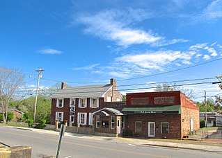
Benton is a town in Polk County, Tennessee, United States. The population was 1,532 at the 2020 census. It is the county seat.

<span class="mw-page-title-main">Copperhill, Tennessee</span> City in Tennessee, United States

Copperhill is a city in Polk County, Tennessee, United States. The population was 443 at the 2020 census. It is included in the Cleveland Metropolitan Statistical Area.

<span class="mw-page-title-main">Ducktown, Tennessee</span> City in Tennessee, United States

Ducktown is a city in Polk County, Tennessee, United States. The population was 461 at the 2020 census and 475 at the 2010 census. It is included in the Cleveland Metropolitan Statistical Area.

<span class="mw-page-title-main">Toccoa/Ocoee River</span> River in Georgia and Tennessee in the United States

The Toccoa River and Ocoee River are the names in use for a single 93-mile-long (150 km) river that flows northwestward through the southern Appalachian Mountains of the southeastern United States. It is a tributary of the Hiwassee River, which it joins in Polk County, Tennessee, near the town of Benton. Three power generating dams are operated along it.

<span class="mw-page-title-main">Nolichucky River</span> River in the Eastern United States

The Nolichucky River is a 115-mile (185 km) river that flows through western North Carolina and East Tennessee in the southeastern United States. Traversing the Pisgah National Forest and the Cherokee National Forest in the Blue Ridge Mountains, the river's watershed includes some of the highest mountains in the Appalachians, including Mount Mitchell in North Carolina, the highest point in the eastern United States. The river is a tributary of the French Broad River and is impounded by Nolichucky Dam near Greeneville, Tennessee.

<span class="mw-page-title-main">Hiwassee River</span> River in Georgia, North Carolina and Tennessee

The Hiwassee River originates from a spring on the north slope of Rocky Mountain in Towns County in the northern area of the State of Georgia. It flows northward into North Carolina before turning westward into Tennessee, flowing into the Tennessee River a few miles west of what is now State Route 58 in Meigs County, Tennessee. The river is about 147 miles (237 km) long.

The Cleveland, Tennessee Metropolitan Statistical Area, as defined by the United States Census Bureau, is an area consisting of two counties in southeast Tennessee – Bradley and Polk – anchored by the city of Cleveland. As of the 2020 United States census, the MSA had a population of 126,164. The MSA is also part of the Chattanooga Combined Statistical Area. The MSA was first designated in June 2003. Geographically, this metropolitan area is mostly coexistant with the Ocoee Region, a historical and cultural name that reflects the heritage of the area.

<span class="mw-page-title-main">Chilhowee Mountain</span>

Chilhowee Mountain is the name of two non-contiguous ridges in the U.S. state of Tennessee. The ridges run in a northeastern to southwestern direction. The northern section is at the outer edge of the Great Smoky Mountains, stretching from the Little Pigeon River watershed at the northeast to the Little Tennessee River and Chilhowee Dam to the southwest. The southern section runs from Tellico Plains to the Ocoee River in Polk County. The northern section is traversed by the Foothills Parkway from Walland to its terminus near Chilhowee.

The name Hiwassee is derived from the Cherokee word Ayuhwasi, meaning "savanna" or "large meadow". The name has been applied to several entities past and present in the U.S. states of Georgia, North Carolina, and Tennessee:

<span class="mw-page-title-main">Ducktown Basin Museum and Burra Burra Mine</span> History museum, heritage center in Tennessee, United States

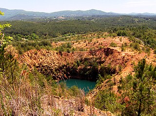
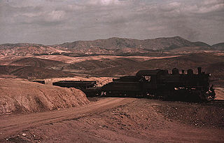
The Burra Burra Mine is a copper mine located in Ducktown, Tennessee, in the southeastern United States. Named for the famous mine in Australia, the Burra Burra Mine is located in the Copper Basin geological region, and extracted over 15 million tons of copper ore during its 60 years of operation between 1899 and 1959. The mine's remaining structures are listed on the National Register of Historic Places as part of the Burra Burra Mine Historic District. The site is also home to the Ducktown Basin Museum, and the museum and mine are a Tennessee State Historic Site operated in partnership with the Tennessee Historical Commission.

<span class="mw-page-title-main">Ocoee Dam No. 2</span> Hydroelectric dam in Tennessee

Ocoee Dam Number 2 is a hydroelectric dam on the Ocoee River in Polk County in the U.S. state of Tennessee. The dam impounds the Ocoee No. 2 Reservoir and is one of three dams on the Toccoa/Ocoee River owned and operated by the Tennessee Valley Authority. It was completed in 1913.

<span class="mw-page-title-main">Ocoee Dam No. 3</span> Dam in Tennessee, United States

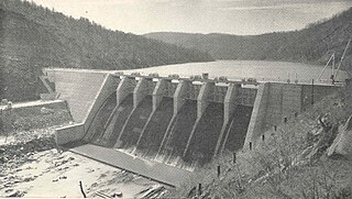
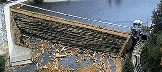
Ocoee Dam No. 3 is a hydroelectric dam on the Ocoee River in Polk County, in the U.S. state of Tennessee. It is one of four dams on the Toccoa/Ocoee River owned and operated by the Tennessee Valley Authority, which built the dam in the early 1940s to meet emergency demands for electricity during World War II. The dam impounds the 360-acre (150 ha) Ocoee No. 3 Reservoir, which stretches 11 miles (18 km) upriver to the Tennessee-Georgia state line. Ocoee No. 3's powerhouse is actually located several miles downstream from the dam, and is fed by a 2.5-mile (4.0 km) conduit that carries water to it from the reservoir.

<span class="mw-page-title-main">Ocoee Whitewater Center</span>

The Ocoee Whitewater Center, near Ducktown, Tennessee, United States, was the canoe slalom venue for the 1996 Summer Olympics in Atlanta, and is the only in-river course to be used for Olympic slalom competition. A 1,640 foot stretch of the Upper Ocoee River was narrowed by two-thirds to create the drops and eddies needed for a slalom course. Today, the course is watered only on summer weekends, 34 days a year, for use by guided rafts and private boaters. When the river has water, 24 commercial rafting companies take more than 750 raft passengers through the course each day.

<span class="mw-page-title-main">Ocoee, Tennessee</span> Unincorporated community in Polk County, Tennessee

Ocoee is an unincorporated community in Polk County, Tennessee, United States and named after the Cherokee settlement located in the area. Ocoee had a post office until it was severely damaged by a tornado. It still retains its own ZIP code 37361.

<span class="mw-page-title-main">U.S. Route 64 in Tennessee</span> Segment of American highway

In Tennessee, U.S. Route 64 stretches 404.1 miles (650.3 km) from the Mississippi River in Memphis to the North Carolina state line near Ducktown. The highway, along with US 72, is a major route for travel between Memphis and Chattanooga.

<span class="mw-page-title-main">Ocoee Scenic Byway</span> Scenic highway in Tennessee

The Ocoee Scenic Byway is a 26-mile (42 km) National Forest Scenic Byway and Tennessee Scenic Byway that traverses through the Cherokee National Forest in East Tennessee. It is part of both U.S. Route 64 and U.S. Route 74 and features the Ocoee Whitewater Center and scenic bluffs along Ocoee River and Gorge.

<span class="mw-page-title-main">Oswald Dome</span> Mountain in Polk County, Tennessee, US

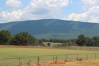
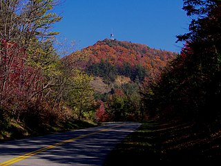
Oswald Dome, also known as Bean Mountain, is a mountain located in the Cherokee National Forest in Polk County, Tennessee. It is part of the Blue Ridge Mountains, which is part of the larger Appalachian Mountains.

<span class="mw-page-title-main">Copper Basin (Tennessee)</span> Geological area in southeastern Tennessee, United States

The Copper Basin, also known as the Ducktown Basin, is a geological region located primarily in Polk County, Tennessee, that contains deposits of copper ore and covers approximately 60,000 acres. Located in the southeastern corner of Tennessee, small portions of the basin extend into Fannin County, Georgia, and Cherokee County, North Carolina. The basin is surrounded by the Cherokee National Forest, and the cities of Ducktown and Copperhill, Tennessee, and McCaysville, Georgia are located in the basin.

References

  1. 1 2 3 4 Marian Bailey Presswood, "Polk County," Tennessee Encyclopedia of History and Culture. Retrieved: March 19, 2013.
  2. 1 2 "State & County QuickFacts". United States Census Bureau. Retrieved December 7, 2013.
  3. "Find a County". National Association of Counties. Retrieved June 7, 2011.
  4. James B. Jones Jr. Towards an Understanding of the History and Material Culture of Pre-TVA Hydroelectric Development in Tennessee, 1900-1933 [ permanent dead link ]. Retrieved: January 22, 2009. PDF.
  5. Tennessee Valley Authority, The Hiwassee Valley Projects Volume 2: The Apalachia, Ocoee No. 3, Nottely, and Chatuge Projects, Technical Report No. 5 (Washington, D.C.: U.S. Government Printing Office, 1948), pp. 1-13, 40, 47, 63, 295, 494.
  6. "Judge Orders Festival Halted". Kingsport Times-News . Kingsport, Tennessee. United Press International. August 24, 1973. Retrieved February 3, 2019 via Newspapers.com.
  7. Jefferson, Jon; Bass, William (September 4, 2007). Beyond The Body Farm: A Legendary Bone Detective Explores Murders, Mysteries, and the Revolution in Forensic Science. Harper Collins. pp. 67–86. ISBN   978-0060875282 via Google Books.
  8. Bowers, Larry C. (April 21, 2019). "Polk is first county in state to be 'gun sanctuary'". Cleveland Daily Banner . Retrieved February 22, 2020.
  9. "2010 Census Gazetteer Files". United States Census Bureau. August 22, 2012. Retrieved April 9, 2015.
  10. Carey, Bill (October 2017). "Conasauga River nearly became important in Tennessee history". Tennessee Magazine. Retrieved June 23, 2020.
  11. "U.S. Decennial Census". United States Census Bureau. Retrieved April 9, 2015.
  12. "Historical Census Browser". University of Virginia Library. Retrieved April 9, 2015.
  13. Forstall, Richard L., ed. (March 27, 1995). "Population of Counties by Decennial Census: 1900 to 1990". United States Census Bureau. Retrieved April 9, 2015.
  14. "Census 2000 PHC-T-4. Ranking Tables for Counties: 1990 and 2000" (PDF). United States Census Bureau. April 2, 2001. Archived (PDF) from the original on October 9, 2022. Retrieved April 9, 2015.
  15. Based on 2010 census data
  16. "U.S. Census website". United States Census Bureau . Retrieved July 7, 2018.
  17. "Explore Census Data". data.census.gov. Retrieved December 25, 2021.
  18. Brooks, Jeanne M. (April 17, 1990). Polk County: An Appalachian Perspective (Thesis). University of Tennessee Honors Thesis Projects. Retrieved June 29, 2020.
  19. "Copper Mines to Whitewater Rafting: Some River History in Polk County Tennessee". Quest Expeditions. June 19, 2015. Retrieved June 29, 2020.
  20. 1 2 "One of the Tamest Waterways in Southeast Tennessee for Beginners to Experience Whitewater Fun". hiwasseeblueway.com. Hiwassee River Blueway. April 29, 2016. Retrieved June 29, 2020.
  21. "The History of Ocoee River in Polk County Tennessee". Blueridgehighlander.com. Retrieved June 29, 2020.
  22. Ahillen, Steve (July 4, 2017). "Ocoee celebrates new contract to keep whitewater flowing". Knoxville News Sentinel . Retrieved June 29, 2020.
  23. "Ocoee River draws throngs of thrill-seeking rafters". The Tennessean . November 12, 2016. Retrieved June 29, 2020.
  24. Coco, Claudia (June 6, 2019). "Rafting on the Ocoee River brings millions in revenue for Polk County". WRCB-TV . Chattanooga, Tennessee. Retrieved June 29, 2020.
  25. Kampis, Johnny. "Top Ten Places to Go in Tennessee". USA Today. Archived from the original on August 12, 2015. Retrieved August 18, 2015.
  26. "POLK CO SCHOOLS". polk-schools.businesscatalyst.com. Polk County Board of Education. Retrieved July 7, 2018.[ permanent dead link ]
  27. Leip, David. "Dave Leip's Atlas of U.S. Presidential Elections". uselectionatlas.org. Retrieved March 12, 2018.
  28. "MARTIN CAMPBELL FIELD - 1A3". tdot.state.tn.us. Tennessee Department of Transportation. Archived from the original on July 13, 2013. Retrieved May 18, 2020.
  29. FAA Airport Form 5010 for 92A PDF
  30. "J. Chris Newton". capitol.tn.gov. Tennessee General Assembly. Retrieved July 14, 2020.

35°08′N84°31′W / 35.13°N 84.52°W / 35.13; -84.52