Hyde Park Township, Cook County, Illinois

Last updated

Hyde Park Township
Hyde Park Township.PNG
The original boundaries of Hyde Park Township, imposed on a current map of Chicago
Coordinates: 41°44′03″N87°34′32″W / 41.7343°N 87.5756°W / 41.7343; -87.5756 Coordinates: 41°44′03″N87°34′32″W / 41.7343°N 87.5756°W / 41.7343; -87.5756
CountryUnited States
StateIllinois
County Cook
Organized1861
Elevation
591 ft (180 m)
Population
 (1889)
  Total85,000
Time zone UTC-6 (CST)
  Summer (DST) UTC-5 (CDT)

Hyde Park Township is a former civil township in Cook County, Illinois, United States that existed as a separate municipality from 1861 until 1889 when it was annexed into the city of Chicago. [1] Its borders are Pershing Road (formerly 39th Street) on the north, State Street on the west, Lake Michigan and the Indiana state line on the east, and 138th Street and the Calumet River on the south. [2] This region comprised much of what is now known as the South Side of Chicago.

Contents

During Chicago's initial explosive growth, it developed from an adjacent swampy area to a full-fledged residential, commercial and resort community. However, due to infrastructure limitations, legislative incentives and the lure of better municipal services it, along with numerous adjoining townships, agreed to be annexed into the city of Chicago, creating the largest city in the United States at that time.

History

Early years

Paul Cornell, the founder of Hyde Park Paul Cornell (1822-1904).jpg
Paul Cornell, the founder of Hyde Park

The township was founded by Paul Cornell, who paid for a topographical survey of the lakefront south of the city in 1852. [3] In 1853, following the advice of Senator Stephen Douglas, he bought 300 acres (1.21 km2) of speculative property between 51st Street and 55th Street and set about developing the first Chicago railroad suburb. [4] [5] [6] This area was 7 miles (11.27 km) south of the mouth of the Chicago River and 6 miles (9.66 km) south of downtown Chicago. In the 1850s, Chicago was still a walkable urban area well contained within a 2 miles (3.22 km) radius of the center. [6] He selected the name Hyde Park to associate the area with the elite neighborhood of Hyde Park in New York as well as the famous royal park in London. [7] By 1855 he began acquiring large land tracts, which he would subdivide into lots for sale in the 1870s. [8]

In 1837, the City of Chicago incorporated, and by the 1870s the surrounding townships had followed suit. [2] After 1850, Cook County was divided into basic governmental entities, [9] which were designated as townships as a result of the new Illinois Constitution. [2] [10] Illinois's permissive incorporation law empowered any community of 300 resident citizens to petition the Illinois legislature for incorporation as a municipality under a municipal charter with more extensive powers to provide services and tax local residents. [2] [11] Hyde Park Township was created by the Illinois General Assembly in 1861 within Cook County. [12] This empowered the township to better govern the provision of services to its increasingly suburban residents. [10]

Annexation and current status

Following the June 29, 1889 elections, [13] several suburban townships voted to be annexed to the city, which offered better services, such as improved water supply, sewerage, and fire and police protection. [2] [11] Hyde Park Township, however, had installed new waterworks in 1883 just north of 87th Street. Nonetheless, the majority of voters in 1889 supported annexation perhaps because of the city's water system for fire prevention [14] or because of the belief that township government had become too unwieldy. [10] After the 1889 annexation Chicago was able to leverage efficiencies as the largest United States city in area and second largest in population. [14]

The township has no current governmental structure or functions, [1] other than being used by the Cook County Assessor's office for taxation valuation and record keeping purposes. [15] The Hyde Park Historical Society also offers middle school and high school awards with eligibility based on the historical boundaries. [16] Hyde Park was the site of the Columbian Exposition of 1893, and is also the location of the University of Chicago, which was founded two years after Hyde Park was annexed into Chicago, in 1891.

Location

Community areas of Chicago by number. US-IL-Chicago-CA.svg
Community areas of Chicago by number.

Hyde Park included the entirety of the following community areas (see map, below right): Hyde Park (41), Kenwood (39), Woodlawn (42), South Shore (43), South Chicago (46), East Side (52), Hegewisch (55), Avalon Park (45), Calumet Heights (48), South Deering (51), Burnside (47), Pullman (50), and Riverdale (54) as well as the southern part of Oakland (36) and the eastern parts of Grand Boulevard (38), Washington Park(40), Greater Grand Crossing (69), Chatham (44), Roseland (49), and West Pullman (53).

Demographics

When first created the township had only 350 residents. [3] The creation of the Union Stock Yards in 1865 changed the evolutionary path of Hyde Park and the neighboring Lake Township, which became the industrial center while Hyde Park became the middle class enclave. [3] The population of the township grew from 3,600 in 1870 to 15,700 ten years later. [17] The Great Chicago Fire saw the population swell. By 1889 the population had reached 85,000. [1]

Notes

  1. 1 2 3 Keating, Ann Durkin (2005). "Hyde Park Township". The Electronic Encyclopedia of Chicago. Chicago Historical Society. Retrieved July 19, 2007.
  2. 1 2 3 4 5 Keating, Ann Durkin (2005). "Annexations and Additions to the City of Chicago". The Electronic Encyclopedia of Chicago. Chicago Historical Society. Retrieved July 18, 2007.
  3. 1 2 3 Pacyga, Dominic A., Chicago Journal, "Hyde Park - from the 1830s to the beginning of Urban Renewal," pp. 5-7, November 25, 1981.
  4. "Graveyards of Chicago Oak Woods Cemetery". Hucke, Matt. 2002. Retrieved April 11, 2007.
  5. Sawyers, June Skinner, Chicago Portraits, "Paul Cornell", pp. 56-7, Loyola University Press, 1991, ISBN   0-8294-0701-4.
  6. 1 2 Conzen, Michael P. (2005). "Commuting". The Electronic Encyclopedia of Chicago. Chicago Historical Society. Retrieved July 19, 2007.
  7. "Hyde Park Community Collection". Chicago Public Library. Retrieved April 11, 2007.
  8. Best, Wallace (2005). "Greater Grand Crossing". The Electronic Encyclopedia of Chicago. Chicago Historical Society. Retrieved July 19, 2007.
  9. "Townships: Townships After 1850". The Electronic Encyclopedia of Chicago. Chicago Historical Society. 2005. Retrieved October 23, 2007.
  10. 1 2 3 Keating, Ann Durkin (2005). "Townships". The Electronic Encyclopedia of Chicago. Chicago Historical Society. Retrieved July 18, 2007.
  11. 1 2 Teaford, Jon C. (2005). "Government, Suburban". The Electronic Encyclopedia of Chicago. Chicago Historical Society. Retrieved July 19, 2007.
  12. Orum, Anthony (2005). "Governing the Metropolis". The Electronic Encyclopedia of Chicago. Chicago Historical Society. Retrieved July 19, 2007.
  13. Cain, Louis P. (2005). "Annexation". The Electronic Encyclopedia of Chicago. Chicago Historical Society. Retrieved September 8, 2008.
  14. 1 2 Cain, Louis P. (2005). "Annexations". The Electronic Encyclopedia of Chicago. Chicago Historical Society. Retrieved July 18, 2007.
  15. "Reassessment Notices for Hyde Park Township Mailed". Cook County Assessor's Office. September 1, 2006. Archived from the original on February 5, 2007. Retrieved July 18, 2007.
  16. "2005 Hyde Park Historical Society Neighborhood History Awards". Hyde Park Historical Society. 2005. Archived from the original on July 6, 2007. Retrieved July 20, 2007.
  17. Louise Carroll Wade, Chicago's Pride: The Stockyards, Packingtown, and Environs in the Nineteenth Century (University of Illinois Press; 1st Pbk. Ed edition, 2002), p. 148

Related Research Articles

<span class="mw-page-title-main">Cook County, Illinois</span> County in Illinois, United States

Cook County is the most populous county in the U.S. state of Illinois and the second-most-populous county in the United States, after Los Angeles County, California. More than 40% of all residents of Illinois live within Cook County. As of 2020, the population was 5,275,541. Its county seat is Chicago, the most populous city in Illinois and the third-most-populous city in the United States.

<span class="mw-page-title-main">Hull House</span> 19th and 20th-century settlement house in the United States

Hull House was a settlement house in Chicago, Illinois, United States that was co-founded in 1889 by Jane Addams and Ellen Gates Starr. Located on the Near West Side of the city, Hull House opened to serve recently arrived European immigrants. By 1911, Hull House had expanded to 13 buildings. In 1912 the Hull House complex was completed with the addition of a summer camp, the Bowen Country Club. With its innovative social, educational, and artistic programs, Hull House became the standard bearer for the movement that had grown nationally, by 1920, to almost 500 settlement houses.

<span class="mw-page-title-main">Hyde Park, Chicago</span> Community area of Chicago

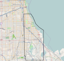
Hyde Park is the 41st of the 77 community areas of Chicago. It is located on the South Side, near the shore of Lake Michigan 7 miles (11 km) south of the Loop.

<span class="mw-page-title-main">Washington Park (community area), Chicago</span> Community area in Chicago

Washington Park is a community area on the South Side of Chicago which includes the 372 acre (1.5 km2) park of the same name, stretching east-west from Cottage Grove Avenue to the Dan Ryan Expressway, and north-south from 51st Street to 63rd. It is home to the DuSable Museum of African American History. The park was the proposed site of the Olympic Stadium and the Olympic Aquatics Center in Chicago's bid to host the 2016 Summer Olympics.

<span class="mw-page-title-main">Austin, Chicago</span> Community area in Chicago

Austin is one of 77 community areas in Chicago Located on the city's West Side, it is the third largest community area by population and the second-largest geographically. Austin's eastern boundary is the Belt Railway located just east of Cicero Avenue. Its northernmost border is the Milwaukee District / West Line. Its southernmost border is at Roosevelt Road from the Belt Railway west to Austin Boulevard. The northernmost portion, north of North Avenue, extends west to Harlem Avenue, abutting Elmwood Park. In addition to Elmwood Park, Austin also borders the suburbs of Cicero and Oak Park.

<span class="mw-page-title-main">Near South Side, Chicago</span> Community area in Chicago

The Near South Side is a community area of Chicago, Illinois, United States, just south of the downtown central business district, the Loop. The Near South Side's boundaries are as follows: North—Roosevelt Road ; South—26th Street; West—Chicago River between Roosevelt and 18th Street, Clark Street between 18th Street and Cermak Road, Federal between Cermak Road and the Stevenson Expressway just south of 25th Street, and Clark Street again between the Stevenson and 26th Street; and East—Lake Michigan.

<span class="mw-page-title-main">Kenwood, Chicago</span> Community area in Chicago

Kenwood, one of Chicago's 77 community areas, is on the shore of Lake Michigan on the South Side of the city. Its boundaries are 43rd Street, 51st Street, Cottage Grove Avenue, and the lake. Kenwood was originally part of Hyde Park Township, which was annexed to the city of Chicago in 1889. Kenwood was once one of Chicago's most affluent neighborhoods, and it still has some of the largest single-family homes in the city. It contains two Chicago Landmark districts, Kenwood and North Kenwood. A large part of the southern half of the community area is in the Hyde Park-Kenwood Historic District. In recent years, Kenwood has received national attention as the home of former U.S. President Barack Obama.

<span class="mw-page-title-main">Calumet Heights, Chicago</span> Community area in Chicago

Calumet Heights, located on the South Side of the city, is one of the 77 well defined community areas of Chicago, Illinois. Calumet Heights is bounded by 87th Street on the north, South Chicago Avenue on the east, and railroad lines on the west and south.

<span class="mw-page-title-main">Hegewisch, Chicago</span> Community area in Chicago

Hegewisch is one of the 77 community areas of Chicago, Illinois, located on the city's far south side. It is bordered by the neighborhoods of Riverdale and South Deering to the west, the East Side to the north, the village of Burnham to the south and the city of Hammond, Indiana to the east. The community area is named for Adolph Hegewisch, the president of U.S. Rolling Stock Company who hoped to establish "an ideal workingman's community" when he laid out the town along a rail line in 1883, six years before Chicago annexed the town.

<span class="mw-page-title-main">Morgan Park, Chicago</span> Community area in Chicago

Morgan Park, located on the far south side of the city of Chicago, Illinois, United States, is one of the city's 77 official community areas. Morgan Park is located south of the Beverly neighborhood and north of the Chicago city border, and includes Mount Greenwood Cemetery. The community, settled in the mid-19th century, was initially known as North Blue Island, being located close to the existing town of Blue Island to the south. As of 2013, Morgan Park was majority-black, with approximately 22,924 residents in 2015.

<span class="mw-page-title-main">Illinois's 2nd congressional district</span> U.S. House district for Illinois

Illinois's 2nd congressional district is a congressional district in the U.S. state of Illinois. Based in the south suburbs of Chicago, the district includes southern Cook county, eastern Will county, and Kankakee county, as well as the city of Chicago's far southeast side.

<span class="mw-page-title-main">Paul Cornell (lawyer)</span> American lawyer; Investor

Paul Cornell was an American lawyer and Chicago real estate speculator who founded the Hyde Park Township that included most of what are now known as the south and far southeast sides of Chicago in Cook County, Illinois, United States. He turned the south side Lake Michigan lakefront area, especially the Hyde Park community area and neighboring Kenwood and Woodlawn neighborhoods, into a resort community that had its heyday from the 1850s through the early 20th century. He was also an urban planner who paved the way for and preserved many of the parks that are now in the Chicago Park District. Additionally, he was a successful entrepreneur with interests in manufacturing, cemeteries, and hotels.

<span class="mw-page-title-main">Washington Park (Chicago park)</span> Public park in Chicago, Illinois

Washington Park is a 372-acre (1.5 km2) park between Cottage Grove Avenue and Martin Luther King Drive, located at 5531 S. Martin Luther King Dr. in the Washington Park community area on the South Side of Chicago. It was named for President George Washington in 1880. Washington Park is the largest of four Chicago Park District parks named after persons surnamed Washington. Located in the park is the DuSable Museum of African American History. This park was the proposed site of the Olympic Stadium and the Olympic swimming venue for Chicago's bid to host the 2016 Summer Olympics. Washington Park was added to the National Register of Historic Places on August 20, 2004.

<span class="mw-page-title-main">Washington Square Park (Chicago)</span> United States historic place

Washington Square, also known as Washington Square Park, is a park in Chicago, Illinois. A registered historic landmark that is better known by its nickname Bughouse Square, it was the most celebrated open air free-speech center in the country as well as a popular Chicago tourist attraction. It is located across Walton Street from Newberry Library at 901 N. Clark Street in the Near North Side community area of Chicago, Illinois, USA. It is Chicago's oldest existing small park. It is one of four Chicago Park District parks named after persons surnamed Washington. It was added to the National Register of Historic Places on May 20, 1991.

<span class="mw-page-title-main">Wigwam (Chicago)</span> Convention center in Chicago (demolished)

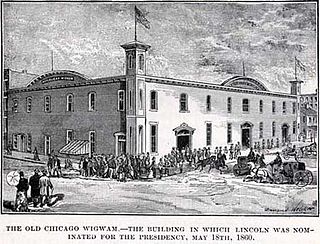
The Wigwam was a convention center and meeting hall that served as the site of the 1860 Republican National Convention. It was located in Chicago, Illinois, at Lake Street and Market near the Chicago River. This site had previously been the site of the Sauganash Hotel, Chicago's first hotel. This is where supporters ushered Abraham Lincoln to the party nomination and the eventual U.S. Presidency. The location at Lake and Wacker was designated a Chicago Landmark on November 6, 2002. The name "Wigwam", although separate structures, was later associated with host locations for both the 1864 Democratic National Convention and the 1892 Democratic National Convention in Chicago.

<span class="mw-page-title-main">South Side, Chicago</span> Area of the City of Chicago, Illinois, USA

The South Side is an area of Chicago, Illinois, U.S. It lies south of the city's Loop area in the downtown. Geographically, it is the largest of the three sides of the city that radiate from downtown, with the other two being the north and west sides.

<span class="mw-page-title-main">Pill Hill, Chicago</span> Neighborhood in Calumet Heights, Chicago

Pill Hill is a neighborhood in the Calumet Heights community area on the South Side of Chicago, Illinois, United States.

Jefferson Township is a former civil township in Cook County, Illinois, United States that existed as a separate municipality from 1850 until 1889 when it was annexed into the city of Chicago. Its borders were Devon Avenue on the north, Harlem Avenue on the west, Western Avenue to the east, and North Avenue to the south. This region comprised most of what is now known as the Chicago's Northwest Side including the entirety of the following community areas: Jefferson Park, North Park, Albany Park, Irving Park, Avondale, Hermosa, Belmont-Cragin, Montclare, Portage Park, as well as parts of Forest Glen, West Ridge, Lincoln Square, North Center, Logan Square, West Town, Humboldt Park, Austin, Dunning, the suburb of Norridge, the suburb of Harwood Heights, and Norwood Park.

References