Hitchin is a market town in the North Hertfordshire district of Hertfordshire, England. The town dates from at least the 7th century. It lies in the valley of the River Hiz at the north-eastern end of the Chiltern Hills. It is 16 miles (26 km) north-west of the county town of Hertford, and 35 miles (56 km) north of London. The population at the 2021 census was 35,220.

Weston is a village and civil parish in the North Hertfordshire district of Hertfordshire, England. In 2011 the parish had a population of 1054.

Kempsey is a village and civil parish in the Malvern Hills District in the county of Worcestershire, England. It is bounded by the River Severn on the west, and the A38 main road runs through it and is about 3 miles (5 km) south of Worcester. The village has a long history. Its name is derived from the Saxon "Kemys' Eye", or the island of Kemys. Kemys was a Saxon chief, whose island lay between marshes and the River Severn. One of the roads in Kempsey, Lyf's Lane, is named after another Saxon chief. The village was recorded in the 11th century Domesday Book as having a value of £7.

Walsworth is a part of the town of Hitchin in Hertfordshire, England. It was originally a village about a mile north east of the town, and later became incorporated into it, although it is still referred to as a village by some locals. Hitchin Walsworth is one of five wards for the purposes of electing councillors to North Hertfordshire District Council. The ward includes the Purwell neighbourhood, south of Walsworth, which is named after the River Purwell.

Pirton is a large village and civil parish three miles northwest of Hitchin in Hertfordshire, England. The population of the civil parish at the 2011 census was 1,274.

Kimpton is a village in Hertfordshire, England, six miles south of Hitchin, seven miles north of St Albans and four miles from Harpenden and Luton. The population at the 2011 Census was 2,167.
Lilley is a small village and civil parish situated between Hitchin and Luton in Hertfordshire, England. Lilley stands on high ground: nearby Telegraph Hill is just over 600 feet above sea level.

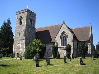
Graveley is a village and civil parish about four miles east of Hitchin and two miles north of Stevenage in Hertfordshire, England. The population of the parish in the 2011 census was 487. A milestone in the village states that it is 33 miles from London.

Barton-le-Clay is a large village and a civil parish in the Central Bedfordshire district of Bedfordshire, England, bordering Hertfordshire. The village has existed since at least 1066 and is mentioned in the Domesday Book.

Barley is a village and civil parish in the district of North Hertfordshire, England. According to the 2001 census, it has a population of 659, increasing to 662 at the 2011 Census. The place-name refers to a lea or meadow and not to the grain-producing plant. Coincidentally to the southwest lies the village of Reed. The Prime Meridian passes to the west of Barley, which is located on the Royston to Saffron Walden road, as well as the medieval London to Cambridge road.
Bassingbourn cum Kneesworth is a civil parish in the South Cambridgeshire district of Cambridgeshire, England, 14 miles south-west of Cambridge and just north of Royston, Hertfordshire. Since the 1960s the parish contains the villages of Bassingbourn and Kneesworth.

North Runcton is a village and a civil parish in the English county of Norfolk. The village is 43.2 miles (69.5 km) west of Norwich, 4.3 miles (6.9 km) south-south-west of King's Lynn and 102 miles (164 km) north of London. The village is located a small distance south-west of the A47 between King's Lynn and Swaffham. The nearest railway station is at King's Lynn for the Fen Line which runs between King's Lynn and Cambridge. The nearest airport is Norwich International Airport. The parish of North Runcton in the 2001 census, has a population of 266, increasing to 549 at the 2011 Census. For the purposes of local government, the parish falls within the district of King's Lynn and West Norfolk.
Lower Stondon is a small village in the Central Bedfordshire district of Bedfordshire, England. It is located close to the border with Hertfordshire, around 2.5 miles (4 km) south-west of Henlow. It is part of the larger Stondon civil parish, which at the 2001 Census had a population of approximately 2,000 increasing to approximately 2,300 at the 2011 Census.

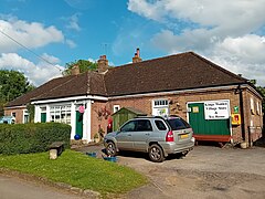
Offley is a civil parish in the English county of Hertfordshire, between Hitchin and Luton. The main village is Great Offley, and the parish also contains the nearby hamlets of Little Offley and The Flints. In the south-west of the parish, near Luton, there are the hamlets of Cockernhoe, Mangrove Green and Tea Green, and also the Putteridge Bury estate; these have LU2 postcodes and 01582 telephone numbers.
Ockley is a rural village in Surrey. It lies astride the A29, the modern road using the alignment of Stane Street (Chichester). The A29 diverges from the A24 from London about 2.5 miles northeast and takes the alignment of Stane Street a mile north of the village. It has a medieval parish church, see list of places of worship in Mole Valley.

Reed is a small village and civil parish in North Hertfordshire. It is situated on a chalk ridge, approximately 3 miles (4.8 km) south of the market town of Royston. The Prime Meridian passes just to the east of the village, between Reed and Barkway. The modern A10 road passes just to the west of the village. The population of the parish was 310 at the time of the 2011 census.

Steeple Morden is a village and civil parish in Cambridgeshire, England, about 15 miles (24 km) south west of Cambridge and 5 miles (8 km) west of Royston. It is part of the South Cambridgeshire local government district.

Northrepps is a village and a civil parish in the English county of Norfolk. It is 3.4 miles (5.5 km) southeast of Cromer, 22.2 miles (35.7 km) north of Norwich and 137 miles (220 km) north of London. The village lies west of the A149 which runs between Kings Lynn and Great Yarmouth. The nearest railway station is at Cromer for the Bittern Line which runs between Sheringham, Cromer and Norwich. The nearest airport is Norwich International Airport. The village and parish of Northrepps had in the 2001 census a population of 839, increasing to 886 at the 2011 Census. For the purposes of local government, the village falls within the district of North Norfolk.

Halnaker is a hamlet in the Chichester district of West Sussex, England. It lies on the A285 road 3.5 miles (5.6 km) northeast of Chichester, where it follows the line of the Roman road to London called Stane Street. There is a pub, The Anglesey Arms. Goodwood House is southwest of the village. North of the village Halnaker Windmill stands on 128 metre/420 feet high Halnaker Hill, a southern outpost of the South Downs. It is in the civil parish of Boxgrove.

Leigh is a civil parish in the English county of Staffordshire. The parish includes the village of Church Leigh, together with the settlements of Withington, Upper Leigh, Lower Leigh, Morrilow Heath, Middleton Green, Dodsley, Godstone, Nobut and Field.