Lake View Terrace, Los Angeles

Last updated
Lake View Terrace
Hansen Dam, Lake View Terrace, California, United States.jpg
Location map San Fernando Valley.png
Red pog.svg
Lake View Terrace
Location within Los Angeles/San Fernando Valley
USA Los Angeles Metropolitan Area location map.svg
Red pog.svg
Lake View Terrace
Lake View Terrace (the Los Angeles metropolitan area)
Coordinates: 34°16′35″N118°21′37″W / 34.27639°N 118.36028°W / 34.27639; -118.36028
Country United States
State California
County Los Angeles
City Los Angeles
Time zone UTC-8 (PST)
  Summer (DST) UTC-7 (PDT)
ZIP code
91342

Lake View Terrace is a suburban neighborhood in the San Fernando Valley region of the City of Los Angeles, California. [1]

Contents

Surrounding areas include the Angeles National Forest, Little Tujunga Canyon, Big Tujunga Canyon, Hansen Dam, Kagel Canyon, and a portion of the Verdugo Mountains. The community lies adjacent to the communities of Sylmar, San Fernando, Shadow Hills, Sunland, Sun Valley, and Pacoima. The area shares the 91342 ZIP code with Sylmar. Lake View Terrace is accessed by the Foothill Freeway (Interstate 210) and the major thoroughfares of which include, Foothill Boulevard, Glenoaks Boulevard, Van Nuys Boulevard and Osborne Street.

The community is middle-class and ethnically mixed, including Latinos, African-Americans, Whites and Asians. [2]

The area hosts a large equestrian community, and is one of the few remaining residential areas in the City of Los Angeles that has private homes zoned for horsekeeping.

Lake View Terrace gained international notoriety as the location of the beating of Rodney King by officers of the Los Angeles Police Department in 1991. Lake View Terrace is also the setting of much of the 2008 film Lakeview Terrace , starring Samuel L. Jackson, although the area used for the neighborhood was actually filmed in Walnut, California.[ citation needed ]

History

Lake View Terrace was a part of the Rancho Tujunga Mexican land grant community. Settlers in Rancho Tujunga sold firewood to residents of El Pueblo, a settlement that was in what is now Los Angeles. In the 1800s Homer and Marie Hansen established a horse ranch in the area. In 1939 the U.S. Army Corps of Engineers seized the horse ranch's land via eminent domain to build a dam due to occurrences of flooding in the northeast and southeast portions of the San Fernando Valley. The Hansen Dam was built in 1940. Alyson Pitarre of the Los Angeles Times said "legend has it that" the name of Lake View Terrace originated from Holiday Lake, a 150-acre (61 ha) lake that was once behind the dam and a popular vacation area in the 1950s; the lake since dried. The Rodney King incident occurred in Lake View Terrace in 1991; Pitarre said that Lake View Terrace "gained notoriety" because of the incident. [3]

Demographics

The Los Angeles Times 's "Mapping L.A." project supplied these neighborhood statistics (as of 2008): population of 12,719 with a median household income of $67,985. [1]

With 2,790 people per square mile, it is among the lowest densities for the city of Los Angeles and among the lowest densities for the county. [1]

Cityscape

Alyson Pitarre of the Los Angeles Times said that Lake View Terrace "is a quiet equestrian community with two distinct faces: town and country." She described the densely populated western side as an "urban" area "characterized by high-density housing and the occasional school." Pitarre said that the eastern side has "a rural feel, with homes zoned for horse-keeping and agriculture." Residents of western Lake View Terrace moved to preserve what Pitarre calls "their semirural lifestyle." The residents, led by the Tujunga Watershed Council, fought many battles to preserve the atmosphere of Lake View Terrace. In November 2003 the residents persuaded the Regional Water Quality Control Board to order the U.S. Army Corps of Engineers to remove construction debris from lakes in the Hansen Dam area. Houses in northeast Lake View Terrace are newer and more expensive. Fenton Grove, which was one of the few new neighborhoods in Lake View Terrace in 2005, is located on Fenton Avenue and has views of the San Gabriel Mountains described by Pitarre as "scenic." More established neighborhoods are located to the east. [3] Omari Mark, a real estate agent, described Lake View Terrace as "a hidden area" that many people do not know about in a 2005 Los Angeles Times article. Mark said that houses in Lake View Terrace were less expensive than those in Sylmar and Tujunga because those two neighborhoods were more well known. [4]

Culture

Alyson Pitarre of the Los Angeles Times said that Lake View Terrace "maintains a laid-back, rural image." Carol Ford, who was the president of the Valley Horse Owners Association in 2005, said "If you don't like the smell of livestock, you shouldn't move here." [3]

Film and television

Lake View Terrace has been used in many films over the years.

Film

Easy Rider (1969), The Dark Side of Tomorrow (1970), Smokey and the Bandit (1977), V (1983)Sunset Strip (1985), Terminator 2: Judgment Day (1991),

Little Rascals (1994), Herbie Fully Loaded (2005), Hole (2010), Star Wars: The Mission (2017), L.A. Burning: The Riots 25 Years Later (2017)

TV

Dynasty, Falcon Crest, Sons of Anarchy, Euphoria

Government and infrastructure

Van Nuys Boulevard Looking South from Lake View Terrace Van Nuys Boulevard Looking South from Lake View Terrace.JPG
Van Nuys Boulevard Looking South from Lake View Terrace

Los Angeles Fire Department Station 24 Sunland/Shadow Hills, [5] located in Sunland, serves Lake View Terrace. [6] The Los Angeles Police Department Foothill Community Police Station in Pacoima serves Lake View Terrace. [7]

Education

Primary and secondary schools

Public schools

The Los Angeles Unified School District serves the community. Two elementary schools, Brainard Avenue Elementary School and Fenton Elementary School, [8] are in the community. In 2005 residents were zoned to Olive Vista Middle School and Sylmar High School. [4]

PUC Schools, a charter school operator, operates PUC Community Charter Middle School, [9] PUC Lakeview Charter Academy, [10] and PUC Community Charter Early College High School. [11]

Private schools

Delphi Academy of Los Angeles, a Delphi Academy school, is in Lake View Terrace. The school was originally in La Cañada Flintridge; the current campus in Lake View Terrace opened in 2003. [12]

Public libraries

Los Angeles Public Library operates the Lake View Terrace Branch Library. [13]

Discovery Cube

On November 13, 2014, Discovery Cube Los Angeles opened its doors in the Hansen Dam Recreation Center. The children's science center has 71,000 square feet and is the first major museum in the San Fernando Valley. [14]

Parks and recreation

Alyson Pitarre of the Los Angeles Times said that Lake View Terrace "is a hub for outdoor recreation." The community has equestrian trails, two golf courses, hills, lakes, three parks, and two recreation centers. [3]

The Lake View Terrace Recreation Center in Lake View Terrace includes barbecue pits, lighted outdoor basketball courts, children's play area, community room, indoor gymnasium, picnic tables, and lighted tennis courts. [15] Several recreational facilities in the Hansen Dam area, including the Hansen Dam Equestrian Center, [16] Hansen Dam Park/Recreation Area and the Hansen Dam Swim Lake Aquatic Center/Pool are in Lake View Terrace. [17] The Hansen Dam Recreation Area, which also acts as a Los Angeles Police Department stop-in center, includes barbecue pits, an unlighted baseball diamond, children's play area, picnic tables, and an unlighted soccer field. [18] The Hansen Dam Aquatic Center, a 40-acre (16 ha) recreational facility on the northwest side of the Hansen Dam Recreation Area, includes a 9-acre (3.6 ha) recreation lake used for fishing, pedal boat rental, and public boating. The center also includes a 1.5 acres (0.61 ha) swimming lake, 50 public restrooms, 25 showers, 20 dressing rooms, and several picnic areas. Users of the park may also jog, picnic, and take boating classes. [19] During each weekend over the summer, the aquatic center received up to 2,000 visitors. [3]

See also

Related Research Articles

<span class="mw-page-title-main">San Fernando, California</span> City in California, United States

San Fernando is a general-law city in the San Fernando Valley region of Los Angeles County, California, in the Los Angeles metropolitan area. It is an enclave in the City of Los Angeles. As of the 2020 census the population of San Fernando was 23,946.

<span class="mw-page-title-main">San Fernando Valley</span> Large populated valley in Los Angeles County, California, US

The San Fernando Valley, known locally as the Valley, is an urbanized valley in Los Angeles County, California. Situated to the north of the Los Angeles Basin, it contains a large portion of the City of Los Angeles, as well as unincorporated areas and the incorporated cities of Burbank, Calabasas, Glendale, Hidden Hills, and San Fernando. The valley is well known for its iconic film studios such as Warner Bros. Studio and Walt Disney Studios. In addition, it is home to the Universal Studios Hollywood theme park.

<span class="mw-page-title-main">Sylmar, Los Angeles</span> Suburban neighborhood of Los Angeles, California

Sylmar is a suburban neighborhood in the San Fernando Valley and is the northernmost neighborhood within the City of Los Angeles. Historically known for its profusion of sylvan olive orchards, Sylmar can trace its past to the 18th century and the founding of the San Fernando Mission. In 1890, olive production was begun systematically. The Sylmar climate was also considered healthy, and so a sanitarium was established, the first in a series of hospitals in the neighborhood. There are fourteen public and eight private schools within Sylmar.

<span class="mw-page-title-main">Pacoima, Los Angeles</span> Neighborhood of Los Angeles in California, United States

Pacoima is a neighborhood in Los Angeles, California. Pacoima is one of the oldest neighborhoods in the San Fernando Valley region of LA.

<span class="mw-page-title-main">Sun Valley, Los Angeles</span> Neighborhood of Los Angeles in California, United States

Sun Valley is a neighborhood in Los Angeles, California in the San Fernando Valley region. The neighborhood is known for its overall youthful population and moderate racial diversity. There are three recreation centers in Sun Valley, one of which is a historic site. The neighborhood has thirteen public schools—including John H. Francis Polytechnic High School and Valley Oaks Center for Enriched Studies (VOCES)—and four private schools.

<span class="mw-page-title-main">California State Route 118</span> Highway in California

State Route 118 is a state highway in the U.S. state of California that runs west to east through Ventura and Los Angeles counties. It travels from State Route 126 at the eastern edge of Ventura immediately northwest of Saticoy, then through Saticoy, in Ventura County east to Interstate 210 near Lake View Terrace in Los Angeles. SR 118 crosses the Santa Susana Pass and the northern rim of the San Fernando Valley along its route.

Shadow Hills is a neighborhood in the Verdugo Mountains and northeastern San Fernando Valley, within the city of Los Angeles, California.

<span class="mw-page-title-main">Hansen Dam</span> Dam in San Fernando Valley

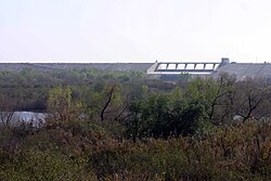
Hansen Dam is a flood control dam in the northeastern San Fernando Valley, in the Lake View Terrace neighborhood of Los Angeles, California. The dam was built by the U.S. Army Corps of Engineers, Los Angeles District in 1940. Hansen Dam was named after horse ranchers Homer and Marie Hansen, who established a ranch in the 19th century.

Los Angeles Mission College is a public community college in Los Angeles, California. It is part of the Los Angeles Community College District and it is accredited by the WASC Accrediting Commission for Community and Junior Colleges.

<span class="mw-page-title-main">California's 29th congressional district</span> U.S. House district for California

California's 29th congressional district is a congressional district in the U.S. state of California based in the north central San Fernando Valley. The district is represented by Democrat Tony Cárdenas.

<span class="mw-page-title-main">Bolton Hall (California)</span> United States historic place

Rancho Tujunga was a 6,661-acre (26.96 km2) Mexican land grant in the western Crescenta Valley and northeastern San Fernando Valley, in present-day Los Angeles County, California. It was granted in 1840 by Mexican governor Juan Alvarado to Francisco Lopez and Pedro Lopez.

<span class="mw-page-title-main">Los Angeles's 1st City Council district</span> American legislative district

Los Angeles's 1st City Council district is one of the fifteen districts in the Los Angeles City Council. It is currently represented by Democrat Eunisses Hernandez since 2022, after she beat previous councilmember Gil Cedillo that year.

<span class="mw-page-title-main">Los Angeles's 2nd City Council district</span> American legislative district

Los Angeles's 2nd City Council district is one of the fifteen districts in the Los Angeles City Council. It is currently represented by Democrat Paul Krekorian since 2009, after he won the special election to finish Wendy Greuel's term.

<span class="mw-page-title-main">Sunland-Tujunga, Los Angeles</span> Neighborhood of Los Angeles in California, United States

Sunland-Tujunga is a Los Angeles city neighborhood within the Crescenta Valley and Verdugo Mountains. Sunland and Tujunga began as separate settlements and today are linked through a single police station, branch library, neighborhood council, chamber of commerce, city council district, and high school. The merging of these communities under a hyphenated name goes back as far as 1928. Sunland-Tujunga contains the highest point of the city, Mount Lukens.

<span class="mw-page-title-main">Big Tujunga Creek</span> River in California, United States

Big Tujunga Creek is a major stream in Los Angeles County in the U.S. state of California. From its headwaters high in the San Gabriel Mountains, it flows generally southwest for 28.8 miles (46.3 km), joining Little Tujunga Creek to form the Tujunga Wash near Pacoima. The stream is sometimes considered as one with the Tujunga Wash, which is the continuation of Big Tujunga to the Los Angeles River, bringing the total length to more than 40 miles (64 km). The name of the stream is derived from a Tongva village name.

<span class="mw-page-title-main">Los Angeles's 7th City Council district</span> American legislative district

Los Angeles's 7th City Council district is one of the fifteen districts in the Los Angeles City Council. It is currently represented by Democrat Monica Rodriguez since 2017 after winning an election to succeed Felipe Fuentes, who resigned the year prior.

<span class="mw-page-title-main">Big Tujunga Dam</span> Dam in Los Angeles County, California

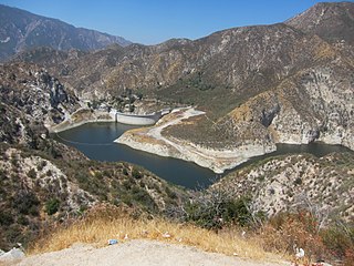
Big Tujunga Dam is a 244-foot-high (74 m) concrete arch dam in Los Angeles County, California, spanning Big Tujunga Canyon northeast of Sunland, in the foothills of the San Gabriel Mountains. Completed in 1931, it provides flood control and groundwater recharge for the San Fernando Valley.

PUC Schools is a charter school operator in Greater Los Angeles. It has its headquarters in Burbank. The charter school systems operates schools in northeast Los Angeles and the northeast San Fernando Valley.

<span class="mw-page-title-main">Creek Fire (2017)</span> 2017 wildfire in Southern California, United States

The Creek Fire was a large wildfire that burned in Kagel Canyon and the Angeles National Forest north of Sylmar, a neighborhood in Los Angeles, California, United States, and one of multiple wildfires that broke out across Southern California in December 2017. The Creek Fire burned 15,619 acres (63 km2) and destroyed 123 structures, including 60 homes, before being contained on January 9, 2018, following heavy rainfall from a winter storm. The fire threatened the communities of Santa Clarita, Glendale, Olive View, Lake View Terrace, Sunland-Tujunga, Shadow Hills, Sylmar, Pacoima, Lopez Canyon, and Kagel Canyon, as well as the Olive View–UCLA Medical Center. During the wildfire, 115,000 residents were forced to evacuate their homes.

References

  1. 1 2 3 "Lake View Terrace," Mapping L.A., Los Angeles Times
  2. "Lake View Terrace". The Los Angeles Times . Retrieved March 9, 2022.
  3. 1 2 3 4 5 Pitarre, Alyson. "Where country living sidles up to the city." Los Angeles Times . June 12, 2005. 1. Retrieved on March 19, 2010.
  4. 1 2 Pitarre, Alyson. "Where country living sidles up to the city." Los Angeles Times . June 12, 2005. 2. Retrieved on March 19, 2010.
  5. "Neighborhood Fire Stations Archived 2010-03-10 at the Wayback Machine ." Los Angeles Fire Department. Retrieved on March 19, 2010.
  6. "Fire Station 24 Archived 2006-11-02 at the Wayback Machine ." Los Angeles Fire Department. Retrieved on March 19, 2010.
  7. "Foothills Community Police Station." Los Angeles Fire Department. Retrieved on March 19, 2010.
  8. "Home - Fenton Charter Public Schools".
  9. "Community Charter Middle School Archived 2011-12-06 at the Wayback Machine ." PUC Schools. Retrieved on November 27, 2011.
  10. "Lakeview Charter Academy Archived 2008-06-14 at the Wayback Machine ." PUC Schools. Retrieved on November 27, 2011.
  11. "Community Charter Early College High School Archived 2011-12-23 at the Wayback Machine ." PUC Schools. Retrieved on November 27, 2011.
  12. "Campus." Delphi Academy of Los Angeles. Retrieved on December 27, 2010.
  13. "Lake View Terrace Branch Library." Los Angeles Public Library. Retrieved on March 19, 2010.
  14. Branson-Potts, Hailey (2014-11-13). "San Fernando Valley's Discovery Cube L.A. opens in once-vacant museum". Los Angeles Times. Retrieved 2015-10-08.
  15. "Lake View Terrace Recreation Center." City of Los Angeles. Retrieved on March 19, 2010.
  16. "久播视频,4438x无码,伊人网址,欧美性XXXX极品少妞".
  17. "Hansen Dam." City of Los Angeles. Retrieved on March 19, 2010.
  18. "Hansen Dam Recreation Area." City of Los Angeles. Retrieved on March 19, 2010.
  19. "Home page." Hansen Dam Aquatic Center. Retrieved on March 19, 2010.

34°16′35″N118°21′37″W / 34.27639°N 118.36028°W / 34.27639; -118.36028