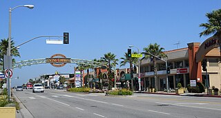
Panorama City is a neighborhood in the city of Los Angeles, California, in the San Fernando Valley. It has a generally young age range as well as the highest population density in the Valley. More than half of the neighborhood's population was born abroad, the majority being from Mexico. Known as the Valley's first planned community after a transition from agriculture to a post-World War II housing boom, it has been home to several notable residents. It is now a mixture of single-family homes and low-rise apartment buildings.
Panorama City has three high schools, two recreational centers, a senior center, ice rink, two hospitals and a chamber of commerce.
History
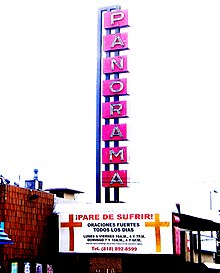
Former Panorama theater converted for church services, 2008
Panorama City is known as the San Fernando Valley's first planned community. In 1948, it was developed as such by residential developer Fritz B. Burns and industrialist Henry J. Kaiser.[1] The master plan was created by architectural firm Wurdeman & Becket.[2] Burns, seeing the tremendous potential fortune that could be made as large numbers of World War II veterans came home and started families, teamed up with Kaiser in 1945 to form Kaiser Community Homes. The vast majority of the houses were bought with loans issued by the Federal Housing Administration or the Servicemen's Readjustment Act of 1944, better known as the G.I. Bill.
Homes in the area were sold with racially discriminatory covenants. A "Conditions, Covenants, Restrictions" document filed with the county recorder declared that no Panorama City lot could be "used or occupied by any person whose blood is not entirely that of the white or Caucasian race."[3] Such restrictive covenants, which sometimes also limited ownership to people "of the Christian faith," were then common in many communities at the time. Although rendered legally unenforceable by the Civil Rights Act of 1968, most of these documents have not been amended to remove the superfluous language.
De facto integration was accelerated by the Community Reinvestment Act of 1977. The CRA-insured credit was provided to the entire community without regard to race or income, causing white flight as with many other areas of the San Fernando Valley.[4] During the period of desegregation busing, Panorama City was exempted due to its diversity.[citation needed]
Panorama City was once adjacent to General Motors'[1] largest assembly plant to date[citation needed]. Today, the Van Nuys Assembly plant has been replaced with a large shopping center called The Plant. A mural on both sides of Van Nuys Boulevard, under the rail bridge across from the Van Nuys Station, pays homage to the glory years of the GM plant.[5]
For the most part, the community is a mixture of small single-family homes and low-rise apartment buildings.[citation needed]
Demographics
The 2010 U.S. census counted 69,817 residents in the neighborhood’s 91402 ZIP code. The median age was 30.1, and the median yearly household income at that time was USD$41,467.[7]
In 2008, the Los Angeles TimesMapping L.A. project described Panorama City as an area that was "moderately diverse" ethnically, with a high percentage of Latinos and a significant population of Filipinos. Filipinos and Mexicans were the most common ancestries in the neighborhood. At that time, the breakdown was Latinos, 70.1%; whites, 11.5%; Asians, 11.9%; blacks, 4.3%; and others, 2.2%. Mexico (52.1%) and El Salvador (13.4%) were the most common places of birth for the 55.0% of the residents who were born outside of the United States—a high percentage for Los Angeles.[8]
As of the 2010 census, renters were occupying 64.8% of the housing stock, while owners held 35.2%.[7]
There were 2,849 families headed by single parents. The rate of 20.2% was considered to be a high one. There were 1,837 veterans, or 4.3% of the population, a low percentage compared to the rest of the city and county.[8]
Parks and recreation
The Panorama Recreation Center is in the community. The center, which also functions as a Los Angeles Police Department drop-in facility, has an auditorium, a lighted baseball diamond, lighted outdoor basketball courts, a children's play area, a community room, an indoor gymnasium, picnic tables, and unlit tennis courts.[9]
The Sepulveda Recreation Center is located in Panorama City.[10] The center has two indoor gymnasiums, both of which can be used as auditoriums. The center also has a lighted baseball diamond, lighted indoor basketball courts, a children's play area, a community room, and lighted tennis courts.[11] The Sepulveda Pool is an outdoor unheated seasonal pool in the Sepulveda center.[11][12]
The Mid-Valley Senior Citizen Center is in Panorama City. The center has an auditorium, a kitchen, and a stage.[13] The building was originally a convalescent home. As of July 2000 the former convalescent home was being converted into the senior center.[10]
The LA Kings Valley Ice Center, formerly known as the Valley Skating Center is an ice rink facility located in Panorama City. The facility has two rinks, the "Freeze" rink to the north, and the "Glacier" rink to the south. The facility offers adult and youth ice hockey programs, learn to play programs, learn to skate for hockey and figure skating. The rink also has public stick times, public skating sessions, and freestyle sessions. Either rink is rentable for birthday parties or other events. Broomball is available if a rink is rented. The rink is home to the California Heat amateur hockey club, who compete in the Southern California Amateur Hockey Association (SCAHA), a league of the California Amateur Hockey Association, which is the largest youth league in the western United States.
Government and infrastructure
The Panorama City Neighborhood Council is a city agency formed by volunteer elected officials and appointed officials. The purpose of the Panorama City Neighborhood Council is to provide an inclusive open forum for public discussion, and to serve as an advisory body on issues of concern to the Panorama City area and in the governance of the city of Los Angeles. The Council gained its official city role upon certification by the Board Of Neighborhood Commissioners on March 15, 2007.
Metro and LADOT operates fixed-route transit bus service in Panorama City. Metro Rapid line 761 operates on Van Nuys Boulevard. Metro Local lines 152, 158, 166, 167, 169, and 233 operate the community. LADOT operates DASH bus service on their Panorama City/Van Nuys route. In 2027, Metro will open the East San Fernando Valley Light Rail Transit Project light rail project with stations on Van Nuys Boulevard at Nordhoff Street & Roscoe Boulevard.
Panorama City was the largest center of major retail outlets in the San Fernando Valley, starting with the opening of what would later become the Panorama Mall in 1955. At the time, this small complex included The Broadway and five other stores.[16] Three other major department stores — Ohrbachs, J. W. Robinson's and Montgomery Ward – opened nearby over the next ten years, and they were marketed collectively as the Panorama City Shopping Center. By the 1970s, the area had lost business to nearby communities.[17][18] The freestanding Ohrbach's building, designed by the architectural firm Welton Becket and Associates, is significant in that it represents "an early and important phase of commercial development" in the neighborhood. It is now the site of the Valley Indoor Swap Meet.[19]
The Panorama Mall remains an important local mall, with a Walmart and Curacao discount stores, the latter catering to the Hispanic market.[20]
Education
Thirteen percent of Panorama City residents aged 25 and older had earned a four-year degree by 2000, an average percentage for both the city and the county. The percentage of the same-age residents with less than a high school diploma was high for the county.[8][21]
Schools within the Panorama City boundaries are:[22]
Kaiser Permanente has a hospital and medical center complex on Woodman Ave. and Roscoe Blvd. serving the central and eastern San Fernando Valley.[24] The complex covers three city blocks as a medical campus first opened in 1963. Mission Community Hospital is a private, for-profit hospital owned by Deanco Healthcare located on Roscoe Blvd. serving the neighborhood. Mission Community Hospital features a basic adult Emergency Room, surgical services, an inpatient psychiatric hospital, and inpatient medical services.[citation needed]
Woodland Hills is a neighborhood bordering the Santa Monica Mountains in the San Fernando Valley region of Los Angeles, California, United States.
Van Nuys is a neighborhood in the central San Fernando Valley region of Los Angeles, California. Home to Van Nuys Airport and the Valley Municipal Building, it is the most populous neighborhood in the San Fernando Valley.
Mission Hills is a suburban neighborhood in the City of Los Angeles, California, located in the San Fernando Valley.
Canoga Park is a neighborhood in the San Fernando Valley region of the City of Los Angeles, California. Before the Mexican–American War, the district was part of a rancho, and after the American victory it was converted into wheat farms and then subdivided, with part of it named Owensmouth as a town founded in 1912. It joined Los Angeles in 1917 and was renamed Canoga Park on March 1, 1931, after Canoga, New York.
The San Fernando Valley, known locally as the Valley, is an urbanized valley in Los Angeles County, California. Situated to the north of the Los Angeles Basin, it contains a large portion of the city of Los Angeles, as well as several unincorporated areas; and the incorporated cities of Burbank, Calabasas, Glendale, Hidden Hills, and San Fernando. The valley is well known for its film studios such as Warner Bros. Studios and Walt Disney Studios. In addition, it is home to the Universal Studios Hollywood theme park.
Reseda is a neighborhood in the San Fernando Valley region of Los Angeles, California. It was founded in 1912, and its central business district started developing in 1915. The neighborhood was devoted to agriculture for many years. Earthquakes struck the area in 1971 and 1994.
Arleta is a neighborhood in the San Fernando Valley region of the city of Los Angeles, California, with a high percentage of Latino residents and of people born outside the United States.
Sherman Oaks is a neighborhood in the city of Los Angeles, California located in the San Fernando Valley, founded in 1927. The neighborhood includes a portion of the Santa Monica Mountains, which gives Sherman Oaks a lower population density than some other areas in Los Angeles.
Encino is a neighborhood in the San Fernando Valley region of Los Angeles, California.
North Hollywood is a Los Angeles, California neighborhood, located in the San Fernando Valley. The neighborhood contains the NoHo Arts District, the El Portal Theatre, several art galleries, and the Academy of TV Arts and Sciences. The North Hollywood Metro Rail station is one of the few subway-accessible Metro Rail stations in Los Angeles.
Pacoima is a neighborhood in Los Angeles, California. Pacoima is one of the oldest neighborhoods in the San Fernando Valley region of LA.
Sun Valley is a neighborhood in Los Angeles, California in the San Fernando Valley region. The neighborhood is known for its overall youthful population and moderate racial diversity. There are three recreation centers in Sun Valley, one of which is a historic site. The neighborhood has thirteen public schools—including John H. Francis Polytechnic High School and Valley Oaks Center for Enriched Studies (VOCES)—and four private schools.
West Hills is an affluent residential community in the western San Fernando Valley region of the City of Los Angeles, California. The percentage of residents aged 35 and older is among the highest in Los Angeles County.
North Hills, known previously as Sepulveda, is a neighborhood in the San Fernando Valley region of Los Angeles, California.
Lake Balboa is a neighborhood in the San Fernando Valley region of Los Angeles, California. The area was previously part of Van Nuys.
Valley Glen is a neighborhood in the southeastern section of the San Fernando Valley in Los Angeles, California. Once part of Van Nuys and North Hollywood, it became a separate neighborhood in 1998. Valley Glen is home to Los Angeles Valley College and the Great Wall of Los Angeles, a half-mile-long California-history mural listed on the National Register of Historic Places.
Victory Boulevard is a major east–west arterial road that runs for 25 miles (40 km) traversing the entire length of the San Fernando Valley in Los Angeles County, California.
Van Nuys Boulevard is a major north-south arterial road that runs through the central San Fernando Valley of Los Angeles County, California. The boulevard was notable for its cruising lifestyle that was prevalent in the 1960s and 1970s, which was depicted in the 1979 film Van Nuys Blvd.
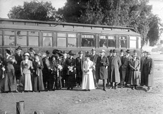
The San Fernando Line was a part of the Pacific Electric Railway system in Los Angeles County, California. It was designed to increase the reach of public transportation from the Downtown Los Angeles and Hollywood into the San Fernando Valley, to support land speculation and development expanding Los Angeles.
Los Angeles's 7th City Council district is one of the fifteen districts in the Los Angeles City Council. It is currently represented by Democrat Monica Rodriguez since 2017 after winning an election to succeed Felipe Fuentes, who resigned the year prior.
This page is based on this Wikipedia article Text is available under the CC BY-SA 4.0 license; additional terms may apply. Images, videos and audio are available under their respective licenses.