Sun Valley, Los Angeles

Last updated

Sun Valley
Stonehurst Recreation Center Building.jpg
Stonehurst Recreation Center building, 2008
Map of Sun Valley, Los Angeles.png
Sun Valley. as delineated by the Los Angeles Times
Location map San Fernando Valley.png
Red pog.svg
Sun Valley
Location within Los Angeles and the San Fernando Valley
U.S. - Los Angeles Metropolitan Area location map.svg
Red pog.svg
Sun Valley
Sun Valley (the Los Angeles metropolitan area)
Coordinates: 34°13′03″N118°22′10″W / 34.2175°N 118.36944°W / 34.2175; -118.36944
CountryUnited States
State California
County Los Angeles
City Los Angeles
Population
 (2008)
  Total81,788

Sun Valley is a neighborhood in Los Angeles, California in the San Fernando Valley region. The neighborhood is known for its overall youthful population and moderate racial diversity. There are three recreation centers in Sun Valley, one of which is a historic site. The neighborhood has thirteen public schools—including John H. Francis Polytechnic High School and Valley Oaks Center for Enriched Studies (VOCES)—and four private schools.

Contents

History

Stone house built in 1925 LA-HCM 644 Stone House 8642 Sunland Blvd (2014).jpg
Stone house built in 1925

The former Tongva/Fernandeño (Native American) village in this area was called Wixánga, which comes from the word wixár (or "thorn" or "prickle" in English) in the Fernandeño dialect of the Tongva language. [1] Hence, Wixánga meant something like "place/canyon of the thorns" in English, in reference to the abundant prickly pear cacti naturally found in the area. This was later reflected in the Spanish name for the area, or Cañada de las Tunas ("canyon of the thorns" in English). Finally, this became La Tuna Canyon, and now Sun Valley.

In 1874, California State Senator Charles Maclay (for whom Maclay Street in San Fernando is named) acquired 56,000 acres (230 km2) of land across the San Fernando Valley. The area extended from Sunland Blvd. all the way west to the Chatsworth Hills. East of Sunland was Rancho San Rafael, a large land grant to José María Verdugo by the Spanish Crown.

By 1876, the Southern Pacific Railroad was constructed through the eastern San Fernando Valley, linking Southern and Northern California. A general store named Roberts Store was used as a post office and water-tank station; later the area's name was changed to Roscoe, reportedly after the name of a railroad crew member. The current name of Sun Valley was chosen in 1950 by residents. [2] [3]

Geography

Sun Valley is bordered on the northeast by Shadow Hills, on the southeast by Burbank, on the south by North Hollywood and Valley Glen, on the west by Panorama City and on the northwest by Pacoima, Hansen Dam and Lake View Terrace. [4]

Situated at the base of the Verdugo Mountains, Sun Valley is prone to flash floods, and one such flood on Sunday, February 20, 2005 at 22:37 (10:37 p.m. PST) destroyed a portion of the 8000 block of Tujunga Avenue and killed a Los Angeles City civil engineer when a sinkhole 30 feet (9.1 m) deep opened. [5]

Demographics

The 2000 U.S. census counted 75,848 residents in the 9.42-square-mile Sun Valley neighborhood—or 8,048 people per square mile, about an average population density for the city. In 2008, the city estimated that the population had increased to 81,788. In 2000 the median age for residents was 28, considered young for city and county neighborhoods; the percentage of residents aged 10 or younger was among the county's highest. [6]

The neighborhood was considered "moderately diverse" ethnically within Los Angeles, with a high percentage of Latinos. The breakdown was Latinos, 69.4%; whites, 17.9%; Asians, 8.1%; blacks, 1.9%; and others, 2.7%. Mexico (54.5%) and El Salvador (11.9%) were the most common places of birth for the 51.9% of the residents who were born abroad—a high percentage for Los Angeles. [6]

The median yearly household income in 2008 dollars was $51,290, considered average for the city but low for the county. The percentages of households that earned $20,000 to $60,000 were high for the county. Renters occupied 46.1% of the housing stock, and house or apartment-owners held 53.9%. [6]

Arts and culture

Old Trapper's Lodge
CHL- 939 Old Trappers Lodge (3514943318).jpg
Location Woodland Hills, Los Angeles
Built1951 to 1981
ArchitectJohn Ehn
Reference no.939

Old Trapper's Lodge, California Historical Landmark No. 939, an outsider art environment that pays homage to the pioneer upbringing of its creator, John Ehn (1897–1981), was situated in Sun Valley. It represented the life work of the self-taught artist who wished to pass on a sense of the Old West, derived from personal experiences, myths, and tall tales. From 1951 to 1981, using his family as models, and incorporating memorabilia, he followed his dreams and visions to create the lodge and its "Boot Hill." The artwork was moved from the original site in Sun Valley, CA, and relocated to Pierce College in Woodland Hills. [7] [8] [9] [10] [11] [12] [13] [14] [15] [16] [17] [18] [19]

The Theodore Payne Foundation for Wild Flowers and Native Plants is located in Sun Valley; it is dedicated to helping people discover the beauty of California native plants.

Parks and recreation

The Sun Valley Recreation Center in Sun Valley includes a public swimming pool, [20] lighted baseball diamond, lighted outdoor basketball courts, a children's play area, a football field, picnic tables, a lighted soccer field, lighted tennis courts, and a lighted volleyball court. [21]

The Fernangeles Recreation Center in Sun Valley includes a public swimming pool, [22] an auditorium, barbecue pits, a lighted baseball diamond, lighted indoor basketball courts, lighted outdoor basketball courts, a children's play area, a lighted football field, an indoor gymnasium with weights, picnic tables, and a lighted soccer field. [23]

The Stonehurst Recreation Center in Sun Valley is a historic site. The center has an indoor gymnasium and auditorium with a capacity of 400 people, barbecue pits, a lighted baseball diamond, lighted outdoor basketball courts, a children's play area, a community room, a lighted football field, an indoor gymnasium with weights, picnic tables, a lighted soccer field, and volleyball courts. [24]

Government and infrastructure

LAFD Fire Station # 77 LAFD Station - 77.JPG
LAFD Fire Station # 77

Sun Valley is part of the City of Los Angeles. Los Angeles Fire Department Fire Station 77 [25] is located in the Sun Valley area. The station is in the Battalion 12 district.

The United States Postal Service Sun Valley Post Office is located at 10946 Ratner Street. [26]

Education

One of every ten of Sun Valley residents aged 25 and older had earned a four-year degree by 2000, a low percentage for both the city and the county. The percentage of the same-age residents with less than a high school diploma was high for the county. [6] [27]

Schools within the Sun Valley boundaries are: [28]

Public

Private

University

Public libraries

The Los Angeles Public Library operates the Sun Valley Branch. [30]

Notable people

Related Research Articles

<span class="mw-page-title-main">Northridge, Los Angeles</span> Neighborhood in California, US

Northridge is a neighborhood in the San Fernando Valley region of the City of Los Angeles. The community is home to California State University, Northridge, and the Northridge Fashion Center.

<span class="mw-page-title-main">Woodland Hills, Los Angeles</span> Neighborhood in California, US

Woodland Hills is a neighborhood bordering the Santa Monica Mountains in the San Fernando Valley region of Los Angeles, California, United States.

<span class="mw-page-title-main">Van Nuys</span> Neighborhood of Los Angeles in California, United States

Van Nuys is a neighborhood in the central San Fernando Valley region of Los Angeles, California. Home to Van Nuys Airport and the Valley Municipal Building, it is the most populous neighborhood in the San Fernando Valley.

<span class="mw-page-title-main">Canoga Park, Los Angeles</span> Neighborhood of Los Angeles

Canoga Park is a neighborhood in the San Fernando Valley region of the City of Los Angeles, California. Before the Mexican–American War, the district was part of a rancho, and after the American victory it was converted into wheat farms and then subdivided, with part of it named Owensmouth as a town founded in 1912. It joined Los Angeles in 1917 and was renamed Canoga Park on March 1, 1931, after Canoga, New York.

<span class="mw-page-title-main">Arleta, Los Angeles</span> Neighborhood of Los Angeles in California, United States

Arleta is a neighborhood in the San Fernando Valley region of the city of Los Angeles, California. It contains a high percentage of Latino residents and of people born outside the United States.

<span class="mw-page-title-main">Wilmington, Los Angeles</span> Neighborhood of Los Angeles in Los Angeles, California

Wilmington is a neighborhood in the South Bay and Harbor region of Los Angeles, California, covering 9.14 square miles (23.7 km2).

<span class="mw-page-title-main">Winnetka, Los Angeles</span> Neighborhood of Los Angeles in California, United States

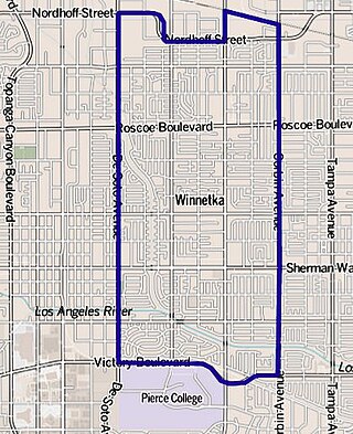
Winnetka is a neighborhood in the west-central San Fernando Valley in the city of Los Angeles. It is a highly ethnically diverse area, both for the city and for Los Angeles County, with a relatively large percentage of Hispanic and Asian people and a small percentage of Arabic people.

<span class="mw-page-title-main">Tarzana, Los Angeles</span> Neighborhood of Los Angeles, California

Tarzana is a suburban neighborhood in the San Fernando Valley region of Los Angeles, California. Tarzana is on the site of a former ranch owned by author Edgar Rice Burroughs. It is named after Burroughs' fictional jungle hero, Tarzan.

<span class="mw-page-title-main">North Hollywood, Los Angeles</span> Neighborhood in Los Angeles, California, United States of America

North Hollywood is a Los Angeles, California neighborhood, located in the San Fernando Valley. The neighborhood contains the NoHo Arts District, the El Portal Theatre, several art galleries, and the Academy of TV Arts and Sciences. The North Hollywood Metro Rail station is the northern terminus of the B Line subway on the Los Angeles Metro.

<span class="mw-page-title-main">Sylmar, Los Angeles</span> Suburban neighborhood of Los Angeles, California

Sylmar is a suburban neighborhood in the San Fernando Valley and is the northernmost neighborhood within the city of Los Angeles. Historically known for its profusion of sylvan olive orchards, Sylmar can trace its past to the 18th century and the founding of the San Fernando Mission. In 1890, olive production was begun systematically. The Sylmar climate was also considered healthy, and so a sanitarium was established, the first in a series of hospitals in the neighborhood. There are fourteen public and eight private schools within Sylmar.

Panorama City is a neighborhood in the city of Los Angeles, California, in the San Fernando Valley. It has a generally young age range as well as the highest population density in the Valley. More than half of the neighborhood's population was born abroad, the majority being from Mexico. Known as the Valley's first planned community after a transition from agriculture to a post-World War II housing boom, it has been home to several notable residents. It is now a mixture of single-family homes and low-rise apartment buildings.

<span class="mw-page-title-main">West Hills, Los Angeles</span> Neighborhood in Los Angeles, California, United States

West Hills is a neighborhood in the western San Fernando Valley region of the city of Los Angeles, California. It is bordered by mountain ranges to the west and the Los Angeles neighborhoods of Chatsworth to the north, Canoga Park to the east, and Woodland Hills to the south.

<span class="mw-page-title-main">Granada Hills, Los Angeles</span> Neighborhood of Los Angeles

Granada Hills is a neighborhood in the San Fernando Valley region of Los Angeles. The community has a sports program and a range of city recreation centers. The neighborhood has fourteen public and ten private schools.

<span class="mw-page-title-main">Mar Vista, Los Angeles</span> Neighborhood of Los Angeles in California, United States of America

Mar Vista is a neighborhood on the Westside of Los Angeles, California. In 1927, Mar Vista became the 70th community to be annexed to Los Angeles. It was designated as an official city neighborhood in 2006.

West Los Angeles is an area within the city of Los Angeles, California, United States. The residential and commercial neighborhood is divided by the Interstate 405 freeway, and each side is sometimes treated as a distinct neighborhood, mapped differently by different sources. Each lies within the larger Westside region of Los Angeles County.

<span class="mw-page-title-main">Lake View Terrace, Los Angeles</span> Neighborhood of Los Angeles in California, United States

Lake View Terrace is a suburban neighborhood in the San Fernando Valley region of the City of Los Angeles, California.

<span class="mw-page-title-main">Lake Balboa, Los Angeles</span> Neighborhood of Los Angeles in California, United States

Lake Balboa is a neighborhood in the San Fernando Valley region of Los Angeles, California. The area was previously part of Van Nuys.

Shadow Hills is a neighborhood in the Verdugo Mountains and northeastern San Fernando Valley, within the city of Los Angeles, California.

<span class="mw-page-title-main">Sunland-Tujunga, Los Angeles</span> Neighborhood of Los Angeles in California, United States

Sunland-Tujunga is a Los Angeles city neighborhood within the Crescenta Valley and Verdugo Mountains. Sunland and Tujunga began as separate settlements and today are linked through a single police station, branch library, neighborhood council, chamber of commerce, city council district, and high school. The merging of these communities under a hyphenated name goes back as far as 1928. Sunland-Tujunga contains the highest point of the city, Mount Lukens.

<span class="mw-page-title-main">Old Trapper's Lodge</span> Historic site in Los Angeles Pierce College

The Old Trapper's Lodge is a California Folk Art display started in 1951 in the United States. It was designated a California Historical Landmark on March 25, 1985. The Old Trapper's Lodge art work is located in Los Angeles Pierce College's Cleveland Park at 6201 Winnetka Avenue in Woodland Hills, Los Angeles in Los Angeles County. The folk art is a life-size sculpture made by John Ehn (1897-1981), a self-taught artist who loved Old West culture. Ehn used his family as models and turned them into life-size outsider art Old West characters.

References

  1. Johnson, John R. "Ethnohistoric Overview for the Santa Susana Pass State Historic Park Cultural Resources Inventory Project" (PDF). Retrieved July 19, 2020.
  2. Ira Gribin, "Sun Valley Once Known as Roberts Store, Roscoe", May 10, 1981, page VB1 (image 679)
  3. Sun Valley Portrait, Los Angeles Times, July 14, 1996
  4. Map, Mapping L.A., Los Angeles Times; accessed November 12, 2016.
  5. "City Civil Engineer Fatality in North Hollywood", LAFD Blogspot; accessed November 12, 2016.
  6. 1 2 3 4 "Sun Valley," Mapping L.A., Los Angeles Times
  7. Russell, Charles (October 24, 2017). Self-taught Art: The Culture and Aesthetics of American Vernacular Art. Univ. Press of Mississippi. ISBN   9781578063802 via Google Books.
  8. Johnson, Marael (August 1, 1995). California Why Stop?: A Guide to California Roadside Historical Markers. Taylor Trade Publishing. ISBN   9781461708568 via Google Books.
  9. "John Ehn - Ancestry.com". search.ancestry.com.
  10. "One Man's Vision of the West – Old Trapper's Lodge Folk Art". March 9, 2017.
  11. Delja, Beatrice. "CHL # 939.5 Old Trapper's Lodge Los Angeles". www.californiahistoricallandmarks.com.
  12. "The Old Trapper's Lodge by John Ehn – Burbank, CA". November 22, 2008.
  13. "John Ehn, CA - John Michael Kohler Arts Center". www.jmkac.org. Archived from the original on October 25, 2017. Retrieved July 30, 2019.
  14. "John Ehn - Historical records and family trees - MyHeritage". www.myheritage.com.
  15. "The Old Trapper's Lodge (Landmark #939-2)! - The Bill Beaver Project". October 23, 2011.
  16. "Old Trapper's Lodge". Harrysonpics.
  17. "NarrowLarry's World of the Outstanding - Old Trapper's Lodge". www.narrowlarry.com.
  18. Design, TOKY Branding + (June 19, 2019). "John Ehn, Old Trapper's Lodge - SPACES". www.spacesarchives.org.
  19. Parzanese, Joe. "Old Trapper's Lodge - Weird California". Weird California.
  20. LA Parks - Sun Valley Swimming Pool & Slide http://laparks.org/dos/aquatic/facility/sunValleyPool.htm
  21. "Sun Valley Recreation Center Archived 2010-02-24 at the Wayback Machine ." City of Los Angeles. Retrieved on March 19, 2010.
  22. LA Parks - Fernangeles Pool
  23. "Fernangeles Recreation Center". City of Los Angeles. Retrieved on March 19, 2010.
  24. "Stonehurst Recreation Center". City of Los Angeles. Retrieved on March 19, 2010.
  25. "Los Angeles Fire Department — Fire Station 77".
  26. "Post Office Location - SUN VALLEY". United States Postal Service. Retrieved on December 6, 2008.
  27. "Less Than High School," Mapping L.A., Los Angeles Times
  28. Sun Valley: Schools. Mapping L.A., Los Angeles Times
  29. "North Valley Service Area- East Valley Skill Center". Archived from the original on November 6, 2014. Retrieved November 9, 2014.
  30. "Sun Valley Branch Library". Los Angeles Public Library.